
Shelby County, Tennessee: Difference between revisions
No edit summary Tag: Mobile edit |
→Major highways: Fixed Poor Linking |
||
| Line 155: | Line 155: | ||
*[[Image:I-269.svg|23px]] [[Interstate 269 (Tennessee)|Interstate 269]] |
*[[Image:I-269.svg|23px]] [[Interstate 269 (Tennessee)|Interstate 269]] |
||
| |
| |
||
*[[Image:US 51.svg|23px]] [[U.S. |
*[[Image:US 51.svg|23px]] [[U.S. Route 51]] |
||
*[[Image:US 61.svg|23px]] [[U.S. |
*[[Image:US 61.svg|23px]] [[U.S. Route 61]] |
||
*[[Image:US 64.svg|23px]] [[U.S. |
*[[Image:US 64.svg|23px]] [[U.S. Route 64]] |
||
*[[Image:US 70.svg|23px]] [[U.S. |
*[[Image:US 70.svg|23px]] [[U.S. Route 70]] |
||
*[[Image:US 72.svg|23px]] [[U.S. |
*[[Image:US 72.svg|23px]] [[U.S. Route 72]] |
||
*[[Image:US 78.svg|23px]] [[U.S. |
*[[Image:US 78.svg|23px]] [[U.S. Route 78]] |
||
*[[Image:US 79.svg|23px]] [[U.S. |
*[[Image:US 79.svg|23px]] [[U.S. Route 79]] |
||
| |
| |
||
*[[Image:Tennessee 1.svg|25px]] [[State Route 1 |
*[[Image:Tennessee 1.svg|25px]] [[Tennessee State Route 1]] |
||
*[[Image:Tennessee 3.svg|25px]] [[State Route 3 |
*[[Image:Tennessee 3.svg|25px]] [[Tennessee State Route 3]] |
||
*[[Image:Tennessee 4.svg|25px]] [[State Route 4 |
*[[Image:Tennessee 4.svg|25px]] [[Tennessee State Route 4]] |
||
*[[Image:Tennessee 14.svg|25px]] [[State Route 14 |
*[[Image:Tennessee 14.svg|25px]] [[Tennessee State Route 14]] |
||
*[[Image:Tennessee 15.svg|25px]] [[State Route 15 |
*[[Image:Tennessee 15.svg|25px]] [[Tennessee State Route 15]] |
||
*[[Image:Tennessee 23.svg|25px]] [[State Route 23 |
*[[Image:Tennessee 23.svg|25px]] [[Tennessee State Route 23]] |
||
*[[Image:Tennessee 86.svg|25px]] [[Tennessee State Route 86 |
*[[Image:Tennessee 86.svg|25px]] [[Tennessee State Route 86]] |
||
*[[Image:Secondary Tennessee 175.svg|25px]] [[Tennessee State Route 175 |
*[[Image:Secondary Tennessee 175.svg|25px]] [[Tennessee State Route 175]] |
||
*[[Image:Secondary Tennessee 176.svg|25px]] [[Tennessee State Route 176 |
*[[Image:Secondary Tennessee 176.svg|25px]] [[Tennessee State Route 176]] |
||
| |
| |
||
*[[Image:Secondary Tennessee 177.svg|25px]] [[Tennessee State Route 177 |
*[[Image:Secondary Tennessee 177.svg|25px]] [[Tennessee State Route 177]] |
||
*[[Image:Secondary Tennessee 204.svg|25px]] [[Tennessee State Route 204 |
*[[Image:Secondary Tennessee 204.svg|25px]] [[Tennessee State Route 204]] |
||
*[[Image:Secondary Tennessee 205.svg|25px]] [[Tennessee State Route 205 |
*[[Image:Secondary Tennessee 205.svg|25px]] [[Tennessee State Route 205]] |
||
*[[Image:Secondary Tennessee 277.svg|25px]] [[Tennessee State Route 277 |
*[[Image:Secondary Tennessee 277.svg|25px]] [[Tennessee State Route 277]] |
||
*[[Image:Secondary Tennessee 278.svg|25px]] [[Tennessee State Route 278 |
*[[Image:Secondary Tennessee 278.svg|25px]] [[Tennessee State Route 278)]] |
||
*[[Image:Tennessee 300.svg|25px]] [[State Route 300 |
*[[Image:Tennessee 300.svg|25px]] [[Tennessee State Route 300]] |
||
*[[Image:Tennessee 385.svg|25px]] [[State Route 385 |
*[[Image:Tennessee 385.svg|25px]] [[Tennessee State Route 385]] |
||
*[[Image:Secondary Tennessee 388.svg|25px]] [[Tennessee State Route 388 |
*[[Image:Secondary Tennessee 388.svg|25px]] [[Tennessee State Route 388]] |
||
*[[Sam Cooper Boulevard]] |
*[[Sam Cooper Boulevard]] |
||
|} |
|} |
||
Revision as of 16:12, 7 March 2014
Shelby County | |
|---|---|
 Shelby County Courthouse | |
 Seal | |
 Location within the U.S. state of Tennessee | |
 Tennessee's location within the U.S. | |
| Coordinates: 35°11′N 89°53′W / 35.18°N 89.89°W | |
| Country | |
| State | |
| Founded | November 24, 1819 |
| Named for | Isaac Shelby[1] |
| Seat | Memphis |
| Largest city | Memphis |
| Area | |
| • Total | 785 sq mi (2,030 km2) |
| • Land | 763 sq mi (1,980 km2) |
| • Water | 22 sq mi (60 km2) 2.8% |
| Population | |
| • Estimate (2012) | 940,764 |
| • Density | 1,230/sq mi (474/km2) |
| Time zone | UTC−6 (Central) |
| • Summer (DST) | UTC−5 (CDT) |
| Website | www |
Shelby County is a county located in the U.S. state of Tennessee. It is the state's largest both in terms of population and geographic area. As of the 2010 census, the population was 927,644.[2] Its county seat is Memphis.Template:GR
Shelby County is part of the Memphis Metropolitan Statistical Area, which comprises ten counties in the three states of Tennessee, Mississippi, and Arkansas.
Shelby County was named for Governor Isaac Shelby (1750–1826) of Kentucky.
History
Shelby County was established in 1819. The county was part of the lands acquired from the Chickasaw as part of the Jackson Purchase of 1818. The county was named for Isaac Shelby, the former governor of Kentucky who had helped negotiate the land acquisition.[1] The county seat was located at Raleigh, on the Wolf River, from 1826 to 1868, when it was moved to Memphis.[1]
Geography
According to the U.S. Census Bureau, the county has a total area of 785 square miles (2,030 km2), of which 763 square miles (1,980 km2) is land and 22 square miles (57 km2) (2.8%) is water.Template:GR The lowest point in the state of Tennessee is located on the Mississippi River in Shelby County (just outside the Memphis city limits), where the river flows out of Tennessee and into Mississippi.
Rivers
Parks and recreation

- Eagle Lake Refuge
- T. O. Fuller State Park
- Lichterman Nature Center
- Meeman-Shelby Forest State Park
- Memphis Parks and Recreation Centers
- Overton Park
- Piperton Wetland Complex (part)
- President's Island Wildlife Management Area
- Shelby Farms
Attractions
- Beale Street, downtown Memphis
- Chucalissa Indian Village, ancient Native American site
- Gibson Guitar factory tour
- Graceland, former home of Elvis Presley
- Indie Memphis, film festival
- Memphis Botanic Garden
- Memphis in May, month-long festival
- Memphis International Raceway
- Memphis Zoo
- Mud Island
- National Civil Rights Museum
- Orpheum Theatre
- Pink Palace Museum and Planetarium
Adjacent counties
- Tipton County (north)
- Fayette County (east)
- Marshall County, Mississippi (southeast)
- DeSoto County, Mississippi (south)
- Crittenden County, Arkansas (west)
Law and government
County government is headed by an elected county mayor and a thirteen-member county commission that is elected from five districts.[3] The members of the county commission serve four-year terms. Other elected officials in Shelby County include the sheriff, the chief law enforcement officer, trustee, chief tax collector, and assessor, the chief property appraiser.[4]
The government has an annual budget of $1.1 billion and 6,000 employees.
Mayors
- Mark Luttrell is the current County Mayor and former Shelby County Sheriff
- Joe Ford served as Interim Mayor in 2009
- A C Wharton 2002-2009 (current Mayor of Memphis)
- Jim Rout 1994-2002[5]
- William N. (Bill) Morris 1978-1994
- Roy Nixon 1976-1978
Demographics
| Census | Pop. | Note | %± |
|---|---|---|---|
| 1820 | 364 | — | |
| 1830 | 5,648 | 1,451.6% | |
| 1840 | 14,721 | 160.6% | |
| 1850 | 31,157 | 111.7% | |
| 1860 | 48,092 | 54.4% | |
| 1870 | 76,378 | 58.8% | |
| 1880 | 78,430 | 2.7% | |
| 1890 | 112,740 | 43.7% | |
| 1900 | 153,557 | 36.2% | |
| 1910 | 191,439 | 24.7% | |
| 1920 | 223,216 | 16.6% | |
| 1930 | 306,482 | 37.3% | |
| 1940 | 358,250 | 16.9% | |
| 1950 | 482,393 | 34.7% | |
| 1960 | 627,019 | 30.0% | |
| 1970 | 722,014 | 15.2% | |
| 1980 | 777,113 | 7.6% | |
| 1990 | 826,330 | 6.3% | |
| 2000 | 897,472 | 8.6% | |
| 2010 | 927,644 | 3.4% | |
| 2012 (est.) | 940,764 | 1.4% | |
2012 Estimate[2] | |||

As of the 2010 United States Census, there were 927,644 people residing in the county. 52.1% were Black or African American, 40.6% White, 2.3% Asian, 0.2% Native American, 3.3% of some other race and 1.4 of two or more races. 5.6% were Hispanic or Latino (of any race).
As of the censusTemplate:GR of 2000, there were 897,472 people, 338,366 households, and 228,735 families residing in the county. The population density was 1,189 people per square mile (459/km²). There were 362,954 housing units at an average density of 481 per square mile (186/km²). The racial makeup of the county was 48.56% Black, or African American, 47.34% White, 0.20% Native American, 1.64% Asian, 0.04% Pacific Islander, 1.20% from other races, and 1.02% from two or more races. 2.60% of the population were Hispanic or Latino of any race.
There were 338,366 households out of which 34.20% had children under the age of 18 living with them, 42.80% were married couples living together, 20.10% had a female householder with no husband present, and 32.40% were non-families. 27.00% of all households were made up of individuals and 7.70% had someone living alone who was 65 years of age or older. The average household size was 2.60 and the average family size was 3.18.

In the county, the population was spread out with 28.20% under the age of 18, 9.70% from 18 to 24, 31.10% from 25 to 44, 21.00% from 45 to 64, and 10.00% who were 65 years of age or older. The median age was 33 years. For every 100 females there were 91.40 males. For every 100 females age 18 and over, there were 86.80 males.
The median income for a household in the county was $39,593, and the median income for a family was $47,386. Males had a median income of $36,932 versus $26,776 for females. The per capita income for the county was $20,856. About 12.90% of families and 16.00% of the population were below the poverty line, including 22.90% of those under age 18 and 13.30% of those age 65 or over.
Shelby County Courthouse
The Shelby County Courthouse, located in Memphis on Adams Avenue between North 2nd and North 3rd streets, was designed by James Gamble Rogers and completed in 1909. This neoclassical pile features a long portico topped by a cornice supported by massive Ionic columns. The ambitious sculptural program designed by J. Massey Rhind includes the pediment groups, Canon Law, Roman Law, Statutory Law, Civil Law and Criminal Law. Female allegorical figures can be found on the north facade cornice representing Integrity, Courage, Mercy, Temperance, Prudence and Learning. Flanking the main entrances are over life sized seated figures embodying Wisdom, Justice, Liberty, Authority, Peace and Prosperity. It was featured in the movie The Silence of the Lambs as the place where Dr. Hannibal Lecter escapes custody. It is by far the largest courthouse in the state.
-
 Justice
 -
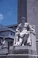 Authority
 -
 Wisdom


Transportation
Major highways
* Once fully completed the mainline of I-69 will run from Brownsville, TX to Port Huron, MI.
Air travel
Shelby County is the site of Memphis International Airport, located 3 miles (5 km) south of the center of Memphis.
Education
Until the end of the 2012-2013 school year, almost all areas in Shelby County that were outside the city of Memphis were zoned to schools operated by Shelby County Schools. Schools in Memphis were operated by Memphis City Schools. On June 30, 2013, both Memphis city and Shelby County schools will consolidate with each other, forming a unified county school system (still called Shelby County Schools). This is expected to last one year until the incorporated suburbs of Arlington, Bartlett, Collierville, Germantown, Lakeland, and Millington break away from the Unified System and form their own municipal districts. These suburbs previously voted in favor of the creation of the municipal school districts, and all voted to pass the related sales tax hike except for Millington, which narrowly rejected the sales tax hike by only three votes.[8] On November 27, 2012, U.S. district court Judge Samuel Mays voided this vote since the state law passed at the time applied only for a specific area (which is unconstitutional). The Tennessee state legislature passed the law again including all of the state. The suburbs are expected to vote again and pass the issue later this year allowing for municipal districts as soon as 2014-2015.
Memphis is home to Baptist College of Health Sciences, Christian Brothers University, Embry–Riddle Aeronautical University, Worldwide (Memphis Campus),[9] Harding School of Theology, LeMoyne–Owen College, Memphis College of Art, Memphis Theological Seminary, Rhodes College, Southern College of Optometry, Southwest Tennessee Community College, University of Tennessee Health Science Center and the University of Memphis.
Cordova is home to Mid-America Baptist Theological Seminary. Germantown is home to a satellite campus of Union University.
Sports
- Memphis Grizzlies, NBA basketball team
- Memphis Redbirds, Triple-A minor league baseball team
Communities
Cities and towns
Unincorporated communities
Notable people
This section needs expansion. You can help by adding to it. (December 2013) |
- James Mortimer Crews, American Civil War veteran and brother of C.C. Crews.
See also
- National Register of Historic Places listings in Shelby County, Tennessee
- Davies Manor, oldest home in Shelby County
References
- ^ a b c Edward F. Williams III, "Shelby County," Tennessee Encyclopedia of History and Culture. Retrieved: 31 March 2013.
- ^ a b "State & County QuickFacts". United States Census Bureau. Retrieved December 7, 2013.
- ^ Shelby County Commission, Shelby County Government website
- ^ Shelby County Topic Page, News about the Shelby County government - The Commercial Appeal
- ^ "Haslam Recruits Former Shelby County Mayor to Leadership Team," TNReport, 30 June 2010. Retrieved: 31 March 2013.
- ^ "U.S. Decennial Census". Census.gov. Retrieved December 7, 2013.
- ^ Based on 2000 census data
- ^ "Voters Choose to Form Municipal School Districts". WMCTV.com. Retrieved 3 August 2012.
- ^ Embry-Riddle Worldwide official website. Retrieved: 31 March 2013.
External links
- ShelbyCountyTN.gov - Official County Government Website
- Shelby County Chambers of Commerce Alliance
- Shelby County at Curlie
Places adjacent to Shelby County, Tennessee | ||||||||||||||||
|---|---|---|---|---|---|---|---|---|---|---|---|---|---|---|---|---|
| ||||||||||||||||
Municipalities and communities of Shelby County, Tennessee, United States | ||
|---|---|---|
| Cities |  | |
| Towns | ||
| Unincorporated communities | ||


Nashville (capital) | |
| Topics | |
| Culture | |
| Grand Divisions | |
| Regions | |
| Largest cities | |
| Metropolitan areas | |
| Combined statistical areas | |
| Micropolitan areas | |
| Counties |
|