Castelnaud-la-Chapelle: Difference between revisions
Appearance
Content deleted Content added
m Reverted edits by 88.137.123.81 (talk) to last version by EP111 |
Rescuing 1 sources and tagging 0 as dead. #IABot (v1.5beta) |
||
| Line 51: | Line 51: | ||
==External links== |
==External links== |
||
{{Commons category|Castelnaud-la-Chapelle}} |
{{Commons category|Castelnaud-la-Chapelle}} |
||
* [http://www.castelnaud.com/uk English Website of the Château de Castelnaud] |
* [https://web.archive.org/web/20081111172011/http://www.castelnaud.com/uk/ English Website of the Château de Castelnaud] |
||
* [http://www.castelnaud.com Château de Castelnaud] |
* [http://www.castelnaud.com Château de Castelnaud] |
||
* [http://www.campingmaisonneuve.com Camping de Castelnaud] |
* [http://www.campingmaisonneuve.com Camping de Castelnaud] |
||
Revision as of 21:29, 31 July 2017
Castelnaud-la-Chapelle | |
|---|---|
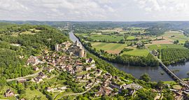
 View of Castelnaud-la-Chapelle and its castle | |
| Coordinates: 44°48′57″N 1°08′58″E / 44.8158°N 1.1494°E | |
| Country | France |
| Region | Nouvelle-Aquitaine |
| Department | Dordogne |
| Arrondissement | Sarlat-la-Canéda |
| Canton | Vallée Dordogne |
| Intercommunality | Domme |
| Government | |
| • Mayor (2001–2008) | Germinal Peiro |
| Area 1 | 20.88 km2 (8.06 sq mi) |
| Population (2008) | 470 |
| • Density | 23/km2 (58/sq mi) |
| Time zone | UTC+01:00 (CET) |
| • Summer (DST) | UTC+02:00 (CEST) |
| INSEE/Postal code | 24086 /24250 |
| Elevation | 51–283 m (167–928 ft) (avg. 71 m or 233 ft) |
| 1 French Land Register data, which excludes lakes, ponds, glaciers > 1 km2 (0.386 sq mi or 247 acres) and river estuaries. | |
Castelnaud-la-Chapelle is a commune in the Dordogne department in Nouvelle-Aquitaine in southwestern France.
The Château de Castelnaud-la-Chapelle is located in the commune.
Geography
The river Céou flows northward through the western part of the commune, then flows into the Dordogne, which forms all of the commune's northern border.
The village is located above the confluence of the two rivers.
Population
| Year | Pop. | ±% |
|---|---|---|
| 1962 | 497 | — |
| 1968 | 440 | −11.5% |
| 1975 | 380 | −13.6% |
| 1982 | 374 | −1.6% |
| 1990 | 408 | +9.1% |
| 1999 | 426 | +4.4% |
| 2008 | 470 | +10.3% |
See also
References
External links
Wikimedia Commons has media related to Castelnaud-la-Chapelle.


