
Askeran Fortress
| Askeran fortress | |
|---|---|
Մայրաբերդ Əsgəran qalası | |
| Askeran, Nagorno-Karabakh | |
.jpg?lang=en) The remains of the fortress | |
| Coordinates | 39°56′00″N 46°49′53″E / 39.9333°N 46.8314°E |
| Type | Fortress |
| Site history | |
| Built | 1751[1] |
| Materials | Cobblestone |
Askeran Fortress (Armenian: Մայրաբերդ, romanized: Mayraberd; Azerbaijani: Əsgəran qalası) is a fortress in the town of Askeran. Located on the banks of the Qarqar River, it was built by the Karabakh Khanate ruler Panah Ali Khan and consists of two sections. The left-bank section features a double line of stone walls.[2][3]
During the Russo-Persian War of 1804–1813 the Russian encampment was near the fortress. In 1810 the peace talks between the Russians and Persians were conducted at the fortress.[2]
Gallery
-
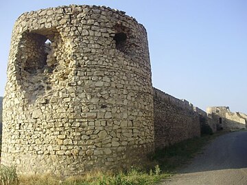 One of the towers of the fortress
 -
 General view

.jpg?lang=en)
Notes
- ^ Carney, James (April 13, 1992). "Former Soviet Union: Carnage in Karabakh". Time. (Archived from the original March 11, 2007.)
- ^ a b Azerbaijan Soviet Encyclopedia (1980), vol. 4, p. 233.
- ^ John Noble, Michael Kohn, Danielle Systermans. Georgia, Armenia and Azerbaijan, Lonely Planet, 2008, p. 306
39°56′00″N 46°49′54″E / 39.9333°N 46.8317°E
