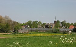
Tuil
Tuil | |
|---|---|
Village | |
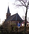
 Kerkje van Tuil | |
| Coordinates: 51°49′22″N 5°14′23″E / 51.82278°N 5.23972°E | |
| Country | Netherlands |
| Province | Gelderland |
| Municipality | West Betuwe |
| Area | |
• Total | 4.00 km2 (1.54 sq mi) |
| Elevation | 3.0 m (9.8 ft) |
| Population (2021)[1] | |
• Total | 1,085 |
| • Density | 270/km2 (700/sq mi) |
| Time zone | UTC+1 (CET) |
| • Summer (DST) | UTC+2 (CEST) |
| Postal code | 4176[1] |
| Dialing code | 0418 |
Tuil is a village in the Dutch province of Gelderland. It is a part of the municipality of West Betuwe, and lies about 14 km west of the town Tiel.
Jan Willem Boellaard has been Lord of Tuil since 1956.
History
[edit]The area now encompassing the village of Tuil was inhabited in Roman times by the Batavians, but by about 800 AD Frankish tribes had occupied the site. The River Waal in this area originally meandered to the north of the present river's course, but spontaneously straightened in the 13th century due to increased river flow, leaving the village streets running at right angles to the river. By the 19th century, after repeated dike breaks at Tuil, a new dike was built along the present-day route that severely truncated the village.[3][4][5][6]
The first known mentions of Tuil appear in feudal documents of 963 AD and 1031 AD.[7] In the 14th century, four members of the family Felder lived near the village of Tuil, and three others to the northern farmland, along the River Linge. This establishes the village of as the place of origin for the family name Felder.[8]
Gallery
[edit]-
Dutch Reformed church
-
House in Tuil
-
House in Tuil
-
Villa in Tuil
References
[edit]- ^ a b c "Kerncijfers wijken en buurten 2021". Central Bureau of Statistics. Retrieved 14 April 2022.
two entries
- ^ "Postcodetool for 4176BA". Actueel Hoogtebestand Nederland (in Dutch). Het Waterschapshuis. Retrieved 14 April 2022.
- ^ Robert Lange and Walter Groenendijk, “The local history of Tuil,” 1996, Chapter 1.
- ^ P. F. Elbers, "Een Opgraving in Tuil," in Mededilingen van de Historiche Kring West-Betuwe, March 1986, pg. 2
- ^ P. F. Elbers, "Tuil, een Bijzonder Dorp," in Mededilingen van de Historiche Kring West-Betuwe, vol. 15, no. 3, 1987, pg. 27
- ^ P. F. Elbers, "De Dijken van Tuil, een Treurige Geschiedenis," in Mededilingen van de Historiche Kring West-Betuwe, August 1992, pg. 28
- ^ Robert Lange and Walter Groenendijk, pg. 13.
- ^ Robert Lange and Walter Groenendijk, pg. 78


