Central Australia
This article needs additional citations for verification. (May 2018) |
| Central Australia Northern Territory | |
|---|---|
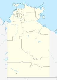
 Location of the Alice Springs Region | |
 Aerial view of Central Australian landscape | |
| Coordinates | 23°42′0″S 133°52′12″E / 23.70000°S 133.87000°E |
| Population | 41,000 (2016)[1] |
| LGA(s) | |
Central Australia, also known as the Alice Springs Region (Eastern Arrernte: Mparntwe Ampere), and colloquially as "The Red Centre", is one of six administrative regions in the Northern Territory of Australia. The main town is Alice Springs. It is sometimes referred to as Centralia; likewise the people of the area are sometimes called Centralians. The region is located in the southern part of the Northern Territory, spanning from the west on the Western Australian Border to the east on the Queensland border.
Geography and governance
There are six regions in the Northern Territory for the purposes of economic planning, as defined by the Northern Territory Government:[2]
- East Arnhem
- Barkly
- Big Rivers
- Central Australia
- Top End
- Darwin, Palmerston & Litchfield
The Central Australia region covers an area of 546,046 square kilometres (210,830 sq mi), which makes up forty percent of the Northern Territory.[citation needed] It covers the southern part of the Northern Territory (NT), and is roughly the equivalent size of the country of Germany, and larger than the Australian state of Victoria.[3]
The main town in Central Australia is Alice Springs. The following Local Government Areas (LGAs) make up the region:[citation needed]
- Town of Alice Springs (town)
- Central Desert Region (region)
- MacDonnell Region (region)
- Yulara (unincorporated town)
Population
The total population of Central Australia is estimated to be 41,000.[1] Alice Springs, the main urban area of Central Australia, is predominantly Anglo-Celtic Australian, with approximately 25% Aboriginal population; however, the surrounding communities which make up Central Australia are almost exclusively Aboriginal. All together, the population of the region is between 40% to 45% Aboriginal, largely Arrernte people.[citation needed]
Climate
The region is very dry, and has a tropical climate receiving on average just 150 millimetres (6 in) of rainfall annually.[4] Most of the annual rainfall falls during extreme rainfall events in the summer months.[5] Moderate dry winters persist between May and October with hot, long summers from November to April.[5]
See also
- Central Australia (territory), Australian federal territory 1927–1931
- Regions of the Northern Territory
- Centre points of Australia
References
- ^ a b "NT regional economic profiles". Department of Trade, Business and Innovation. Northern Territory Government. 18 April 2016. Retrieved 11 August 2017.
- ^ "Strengthening the regions". Department of the Chief Minister and Cabinet. 26 September 2022. Retrieved 9 November 2022.
- ^ "Hermannsburg Historic Precinct and Finke River Mission Today". Hermannsburg Historic Precinct. Retrieved 9 November 2022.
- ^ Laity, Julie J. (2009). Deserts and Desert Environments. John Wiley & Sons. pp. 43, 45. ISBN 978-1444300741. Retrieved 8 November 2012.
- ^ a b Boas, T.; Mallants, D. (April 2022). "Episodic extreme rainfall events drive groundwater recharge in arid zone environments of central Australia". Journal of Hydrology: Regional Studies. 40. doi:10.1016/j.ejrh.2022.101005. Retrieved 12 October 2022.

