
Mount Datuk
| Mount Datuk | |
|---|---|
 Western face of Datuk, with its distinctive tor visible as a bulge at the slopes of the south peak. | |
| Highest point | |
| Elevation | 884 m (2,900 ft) |
| Coordinates | 2°33′02.8″N 102°10′58.7″E / 2.550778°N 102.182972°E |
| Naming | |
| Native name | Gunung Datuk (Malay) |
| Geography | |
 Mount Datuk Location in Malaysia | |
| Location | Rembau and Kuala Pilah Districts, Negeri Sembilan |
| Parent range | Titiwangsa Mountains |
| Climbing | |
| Easiest route | Hiking via Batang Nyamor (west) or Tampin (south) |
Mount Datuk (Malay: Gunung Datuk; Jawi: ڬونڠ داتق), also known as Mount Rembau, is a mountain situated on the border between Batang Nyamor, Rembau District and Johol, Kuala Pilah District in the Malaysian state of Negeri Sembilan, at the southern section of the Titiwangsa Mountains. At around 884 m (2,900 ft), it is the highest mountain in the district of Rembau.[1]
Toponymy
The mountain gets its name from Datuk Perpatih Nan Sebatang, the creator of the Adat Perpatih, a matrilineal customary law that is widely practiced in the state. Circa 1372, on this very mountain he organized a gathering with other local chieftains to elect a new Lembaga, which is a title of the leader of a suku, where the suku is analogous to a clan.[2] Due to its connection to Datuk Perpatih Nan Sebatang, the mountain also earned the sobriquet Gunung Beradat (lit. 'mountain of customs').
Description
Mount Datuk is situated near the southern end of the Titiwangsa Mountains, a long contiguous mountainous chain that runs northwest–southeast from Southern Thailand to the town of Tampin, near the Negri–Malaccan border. At 884 m above sea level, it is the tallest peak in Rembau District, and the sixth tallest in Negeri Sembilan overall. Mount Angsi, which is 59 m shorter, stands 21 km (13 mi) north of Datuk.

The main highlight of the mountain is a tor made of large granite boulders, at the elevation of 855 m (2,805 ft).[3][4]
Tourism
Mount Datuk is one of Negeri Sembilan's popular spots for hiking, especially from within the state itself, the Klang Valley and Malacca. Hikers approaching the tor can get to enjoy a 360° panoramic view of the surrounding area of Rembau District. On clear sunny days, the Strait of Malacca, as well as Malacca City are also visible from this point.
Datuk is also the northern terminus of the Trans-Naning Trail, a 21 km long hiking trail that brings hikers explore the last seven peaks of the Titiwangsa Mountains, ending south at Mount Tampin.[5]
Gallery
-
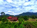 View of the Titiwangsa Mountains near Kampung Gadong, with Datuk rising to the east (right hand side of the image).
 -
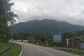 Mount Datuk, seen from Negeri Sembilan State Route
 N111 northbound to Bongek.


See also
References
- ^ http://www.mdr.gov.my/ms/pelawat/hutan-lipur-gunung-datuk
- ^ https://www.bharian.com.my/bhplus-old/2015/03/39816/laluan-pendakian-tiba-tiba-menghilang
- ^ https://www.freemalaysiatoday.com/category/top-lifestyle/2021/06/12/gunung-datuk-a-jewel-of-negeri-sembilan/
- ^ https://kakisondol.blogspot.com/2018/06/gunung-datuk.html?m=1
- ^ https://www.utusan.com.my/nasional/2022/08/cabaran-trans-naning-ultra-ns-bakal-bertaraf-antarabangsa/