
David Range


The David Range (67°54′S 62°30′E / 67.900°S 62.500°E is a mountain range that extends for 26 kilometres (16 mi) in the Framnes Mountains of Mac.Robertson Land in Antarctica.[1] The range is surrounded by, and largely covered by, an ice sheet. Only the peaks are visible.[2]
Discovery
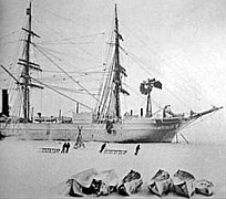
The range was first seen by the British Australian and New Zealand Antarctic Research Expedition (BANZARE) on the evening of 4 January 1930 as a mirage on the horizon. The peaks of the Masson Range and Casey Range were also visible in the mirage. On 14 February 1931 the range was mapped from the Discovery. Sir Douglas Mawson, named the range for Professor Edgeworth David of the BANZARE committee.[3]
-

-
-
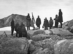 Mawson's BANZARE team claim Mac. Robertson Land


Location

The 'David Range (67°54′S 62°30′E / 67.900°S 62.500°E) is 5 miles (8 km) west of the Masson Range, which it parallels, in the Framnes Mountains of Antarctica. It extends 16 miles (26 km) in a north-northeast–south-southwest direction, with peaks rising to 1,500 metres (4,900 ft).[1]
The range lies to the south of Holme Bay, to the southwest of Mawson Station.[4] [a] The Masson Range is to the east, the Brown Range (or Sortindane Peaks) to the south and the Casey Range to the east.[4]
Appearance
The Framnes Mountains have elevations up to 1,500 metres (4,900 ft) above sea level, and rise up to 400 metres (1,300 ft) above the ice surface. They have dark,weathered charnockite bedrock that is littered with light-coloured quartz-rich, granitic gneiss glacial erratics.[2]
According to the 1960 Sailing Directions for Antarctica
The David Range lies parallel to the Masson Range and about 5 miles to the westward. It is a striking rugged mass stretching southward about 15 miles. It is about 3,500 feet high with the highest elevation in Mount Coates, about 4,600 feet high, near the southern end of the ridge. Mount Hordern, about 4,954 feet high, is a conspicuous mounain lying about 5 miles southard of the Coates massif.[6]
Glaciation
The East Antarctic Ice Sheet (EAIS) formed about 34 million years ago, and seems to have persisted since then with periodic fluctuations in thickness between glacial and inter-glacial cycles.[7] During the last glacial cycle the ice sheet thickened more near the coast, less further incland. This is shown by the upper limit of glacial erratic boulders, ranging from 820 metres (2,690 ft) on Fang Peak near the sea in the north of David Range, to 860 metres (2,820 ft) on Mount Elliot, 1,100 metres (3,600 ft) on Mount Coates and 1,300 metres (4,300 ft) on Mount Hordern, which is about 30 kilometres (19 mi) from the sea.[2] The ice surface appears have lowered by several hundred meters during the present interglacial.[8]
Today the range has a number of small mountain glaciers.[9] The David and Masson ranges divide the ice flow in the Framnes Mountains into three outlet glacial streams. Ice surfsce velocities of 21 metres (69 ft) per year have been measured in the ice stream to the east of the David Range, and 31 metres (102 ft) per year in the ice stream to the west.[10] In the period between January and September 1956 ice in the plateau near the range moved up to 36 feet (11 m).[9]
Features

The features are listed from north to south
Mount Parsons
67°47′S 62°35′E / 67.783°S 62.583°E. Prominent pointed peak, 1,120 m. standing in the David Range. 1 mi SSW of its N extremity. Mapped by Norwegian cartographers from aerial photos taken by the Lan Christensen Expedition. 1936-37. The peak was visited in January 1956 by an ANARE party led by John Bechervaise. Named by ANCA for Neville Parsons. cosmic ray physicist at Mawson Station, 1955. 14.[11]
Fang Peak
67°46′32″S 62°34′31″E / 67.77556°S 62.57528°E. Fang Peak is about 3 kilometres (1.9 mi) south of Mount Parsons and is 1,032 metres (3,386 ft) high. It is a prominent conical peak, named because its shape resembles a tooth.[12] The peak emerges from an unusually clear frozen lake. The slopes of the mountain below the ice surface are visible, as are other mountains that are completely covered by the ice.[13]
In 1959 J C Armstrong, surveyor at Mawson, used the peak as an unoccupied trigonometrical station.[12] In January 2023 a team from the Mawson Mountaineering Club climbed the peak.[14]
Mount Elliot
67°49′18″S 62°33′27″E / 67.82169°S 62.55750°E- At 1,236 metres (4,055 ft) the mountain is the highest point of the northern ridge of the David Range. ir Douglas Mawson first saw it from the sea in 1930. It was first climbed in January 1956 by an ANARE party led by J.M. Béchervaise. The peak is named after F.W., Elliott, weather observer at Mawson Station in 1955.[15]
Mount Lawrence
(67°51′S 62°31′E / 67.850°S 62.517°E. Peak, 1,230 m, just N of Mount Coates in the David Range of the Frammes Mountains, Mac. Robertscm Land. Mapped by Norwegian cartographers from air photos taken by the Lan Christensen Expedition. 1936-37. Named by ANCA for J. Lawrence, diesel mechanic, at Mawson Station in 1959. [16]
Mount Coates
67°52′S 62°31′E / 67.867°S 62.517°E Peak, 1,280 m, just S of Mount Lawrence in the David Range of the Framnes Mountains. Discovered and named in February 1931 by the BANZARE under Mawson..[17]
Hordern Gap
67°53′S 62°30′E / 67.883°S 62.500°E Gap, 3 mi wide, between Mount Coates and Mount Hordern in the David Range of the Framnes Mountains. Mapped by Norwegian cartographers from aerial photographs taken by the Lars Chris- tensen Expedition, 1936-37. This gap was used by AN ARE parties in 1957 and 1958 as a route through the range. Named by AN ARE for its proximity to Mount Hordern.[18]
Gap Nunatak
67°54′S 62°29′E / 67.900°S 62.483°E Small nunatak, 1,030 m, standing in the center of Hordern Gap in the David Range, Framnes Mountains. Mapped by Norwegian cartographers from air photos taken by the Lars Christensen Expedition, 1936-37, and named Metoppen (the middle peak). Renamed by ANARE for its location in Hordern Gap. Not: Metoppen.[19]
Mount Hordern
67°56′S 62°29′E / 67.933°S 62.483°E. Peak, 1,510 m, standing 4 mi S of Mount Coates in the David Range. Discovered in February 1931 by the BANZARE under Mawson, and named for Sir Samuel Horden, a patron of this expedition and the AAE under Mawson, 1911-14.[18]
Smith Peaks
67°57′S 62°29′E / 67.950°S 62.483°E.
Group of peaks standing close S of Mount Hortlem in the David Range of the Francs Mountains. Mapped by Norwegian cartographers from aerial photographs taken by the Lan Christensen Expedition, 1936-37. Remapped by ANARE, 1957-60. and named by ANCA for F.A. Smith, diesel mechanic at Mawson Station, 1957. [20]
Dunlop Peak
67°56′54″S 62°27′52″E / 67.94822°S 62.46439°E. The southern peak of Smith Peaks. It is about 2 kilometres (1.2 mi) south of Mount Hordern. It is named for R. Dunlop, cosmic ray physicist at Mawson Station in 1959.[21]
Mount Tritoppen
67°59′S 62°29′E / 67.983°S 62.483°E. A triple-peaked mountain. 1,350 m. standing 3 mi S of Mount Hordern in the David Range of the Framnes Mountains. Mapped by Norwegian cartographers from aerial photographs taken by the Lan Christensen Expedition. 1936-37. and named Tritoppen (the three-peaked mountain). Not: Tritoppen. Tritoppen Peak.[22]
Mount Twintop
68°5′S 62°22′E / 68.083°S 62.367°E. A twin-peaked mountain about 6 mi SSW of Mount Tritoppen in the S part of the David Range, Frarnnes Mountains. Mapped by Norwegian cartographers from air photos taken by the Lars Christensen Expedition (1936-37) and named Tvitoppen (the twin peak). The translated form of the name recommended by ANCA has been adopted. Not: Tvitoppen Peak.[23]
Bypass Nunatak
68°01′S 62°28′E / 68.017°S 62.467°E A nunatak about 2 mi S of Mount Tritoppen in the David Range of the Framnes Mountains. Mapped by Norwegian cartographers from air photos taken by the Lars Christensen Expedition (1936-37) and called Steinen (the stone). It was renamed by ANARE because the feature marked the turning point in the route taken by the 1958 ANARE seismic party in order to bypass dangerous terrain to the southwest. Not: Steinen.[24]
See also
- Simpson Ridge, a feature nearby Mount Twintop
References
- ^ Mawson Station was named in honour of the Australian Antarctic explorer Sir Douglas Mawson.[5]
- ^ a b Alberts 1995, p. 174.
- ^ a b c MackintoshVerleyenO'BrienWhite 2014, p. 25.
- ^ DavidAADC.
- ^ a b AADCMap.
- ^ NawsonHist.
- ^ SailingDir, p. 293.
- ^ MackintoshVerleyenO'BrienWhite 2014, p. 11.
- ^ MackintoshVerleyenO'BrienWhite 2014, p. 26.
- ^ a b Minard 1951, p. 19.
- ^ Marmo & Dawson 1996, p. 388.
- ^ Alberts 1995, p. 558.
- ^ a b FangAADC.
- ^ Williams 2020.
- ^ FangAAP.
- ^ MountElliottAADC.
- ^ Alberts 1995, p. 423.
- ^ Alberts 1995, p. 1425.
- ^ a b Alberts 1995, p. 345.
- ^ Alberts 1995, p. 268.
- ^ Alberts 1995, p. 687.
- ^ DunlopPeakAADC.
- ^ Alberts 1995, p. 760.
- ^ Alberts 1995, p. 767.
- ^ Alberts 1995, p. 109.
Sources
- Framnes Mountains Satellite Image Map, Australian Antarctic Data Centre, retrieved 2023-11-18
- Alberts, Fred G., ed. (1995), Geographic Names of the Antarctic (PDF) (2 ed.), United States Board on Geographic Names, retrieved 2023-11-07
 This article incorporates public domain material from websites or documents of the United States Board on Geographic Names.
 - The ascent of Fang Peak, Australian Antarctic Program, 20 January 2023, retrieved 2023-11-18
- Dunlop Peak, Australian Antarctic Data Centre, retrieved 2023-11-18
- Fang Peak, Australian Antarctic Data Centre, retrieved 2023-11-18
- Minard, James P. (1951), Glaciology and Glacial Geology of Antarctica, United States. Antarctic Projects Office, retrieved 2023-11-15
- Mount Elliott, Australian Antarctic Data Centre, retrieved 2023-11-18
- David Range, Australian Antarctic Data Centre, retrieved 2023-11-15
- Mackintosh, Andrew N.; Verleyen, Elie; O'Brien, Philip E.; White, Duanne A. (15 September 2014), "Retreat history of the East Antarctic Ice Sheet since the Last Glacial Maximum", Quaternary Science Reviews, 100: 10–30
{{citation}}: CS1 maint: ref duplicates default (link) - Marmo, B. A.; Dawson, J. (1996), "Movement and structural features observed in ice masses, Framnes Mountains, Mac.Robertson Land, East Antarctica]", Annals of Glaciology, 23, Cambridge University Press: 388–395, doi:10.3189/S0260305500013689
- "Mawson station: a brief history", History of Australian Antarctic stations, Australian Antarctic Division, 12 August 2010, retrieved 8 July 2016
- Sailing Directions for Antarctica: Includes Islands South of Latitude 60", United States. Defense Mapping Agency. Hydrographic Center ', 1960, retrieved 2023-11-15
- Williams, Matt (7 November 2020), Post Fang Peak, Australian Antarctic Program, retrieved 2023-11-18
External links
- David Range on AADC website
- David Range on SCAR website
- images of the David Range
- David Range area satellite image
- David Range area map
