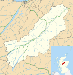
Catlodge
Appearance
Catlodge
| |
|---|---|
 | |
Location within the Badenoch and Strathspey area | |
| OS grid reference | NN636931 |
| Council area | |
| Country | Scotland |
| Sovereign state | United Kingdom |
| Post town | Laggan |
| Postcode district | PH20 1 |
| Police | Scotland |
| Fire | Scottish |
| Ambulance | Scottish |
Catlodge (Scottish Gaelic: Caitleag) is a hamlet, in the district of Newtonmore in Inverness-shire, Scottish Highlands and is in the Scottish council area of Highland.[1] It is located east of Loch Laggan and 7 miles (11 kilometres) north of Dalwhinnie. One of General Wade's military road, which is now the A889, built in the mid 18th century, passes through Catlodge, approaching from the south.
References
[edit]- ^ "Catlodge". The Gazetteer for Scotland. School of GeoSciences, University of Edinburgh and The Royal Scottish Geographical Society. Retrieved 17 June 2018.
External links
[edit]
Wikimedia Commons has media related to Catlodge.

