Dashtiari County
Appearance
Dashtiari County
Persian: شهرستان دشتیاری | |
|---|---|
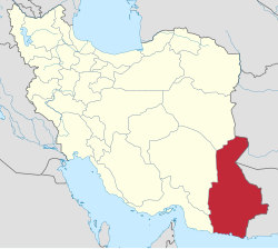
 Location of Dashtiari County in Sistan and Baluchestan province (bottom right, pink) | |
 Location of Sistan and Baluchestan province in Iran | |
| Coordinates: 25°30′38″N 61°22′58″E / 25.51056°N 61.38278°E[1] | |
| Country | Iran |
| Province | Sistan and Baluchestan |
| Capital | Negur |
| Districts | Central, Bahu Kalat |
| Population (2016) | |
| • Total | 79,911 |
| Time zone | UTC+3:30 (IRST) |
Dashtiari County (Persian: شهرستان دشتیاری) is in Sistan and Baluchestan province, Iran. Its capital is the city of Negur,[2] whose population at the time of the 2016 National Census was 5,670 people in 1,320 households.[3]
History
[edit]After the 2016 census, the village of Beris was elevated to the status of a city.[4] In 2018, Dashtiari District was separated from Chabahar County in the establishment of Dashtiari County, which was divided into two districts of two rural districts each, with Negur as its capital.[2]
Demographics
[edit]Administrative divisions
[edit]Dashtiari County's administrative structure is shown in the following table.
| Administrative Divisions |
|---|
| Central District |
| Negur RD |
| Sand-e Mir Suiyan RD |
| Beris (city)[a] |
| Negur (city) |
| Bahu Kalat District |
| Bahu Kalat RD |
| Darkas RD |
| RD = Rural District |
See also
[edit]![]() Media related to Dashtiari County at Wikimedia Commons
Media related to Dashtiari County at Wikimedia Commons
Notes
[edit]References
[edit]- ^ OpenStreetMap contributors (9 April 2023). "Dashtiari County" (Map). OpenStreetMap (in Persian). Retrieved 9 April 2023.
- ^ a b Jahangiri, Ishaq (13 September 2018). "Letter of approval regarding the country divisions of Chabahar County, Sistan and Baluchestan province". Qavanin (in Persian). Ministry of Interior, Council of Ministers. Archived from the original on 7 April 2023. Retrieved 7 April 2023.
- ^ "Census of the Islamic Republic of Iran, 1395 (2016)". AMAR (in Persian). The Statistical Center of Iran. p. 11. Archived from the original (Excel) on 23 December 2021. Retrieved 19 December 2022.
- ^ a b Kariminejad, Rostam (25 November 1400). "Opening of Beris Dashtiari Municipality and the bright future of this fishing port". IRNA (in Persian). Archived from the original on 17 February 2022. Retrieved 7 April 2023.

