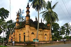
Tala Upazila
This article needs additional citations for verification. (September 2015) |
Tala
তালা | |
|---|---|
 Tetulia Jame Mosque | |
 | |
| Coordinates: 22°45′N 89°15′E / 22.750°N 89.250°E | |
| Country | |
| Division | Khulna |
| District | Satkhira |
| Area | |
| • Total | 337.24 km2 (130.21 sq mi) |
| Population | |
| • Total | 326,111 |
| • Density | 970/km2 (2,500/sq mi) |
| Time zone | UTC+6 (BST) |
| Postal code | 9420[2] |
| Climate | Aw |
| Website | tala |
Tala (Bengali: তালা) is an upazila of the Satkhira District in the Khulna Division of Bangladesh.
Geography
[edit]Tala is located at 22°45′00″N 89°15′00″E / 22.7500°N 89.2500°E and has a total area of 337.24 km2.
History
[edit]Tala thana was established in 1913 and made an upazila in 1983.[3]
Demographics
[edit]As of the 2011 Census of Bangladesh, Tala upazila had 72,465 households and a population of 299,820. 55,963 (18.67%) were under 10 years of age. Tala had an average literacy rate of 50.88%, compared to the national average of 51.8%, and a sex ratio of 1007 females per 1000 males. 9,528 (3.18%) of the population lived in urban areas.[5][6]
As of the 1991 Bangladesh census, Tala has a population of 251,388. 51.31% of the population is male, and 48.69% is female.[7]
Administration
[edit]Tala Upazila is divided into 12 union parishads: Dhandia, Islamkati, Jalalpur, Khalilnagar, Khalishkhali, Khesra, Kumira, Magura, Nagarghata, Sarulia, Tala, and Tentulia. The union parishads are subdivided into 150 mauzas and 229 villages.[5]
Education
[edit]According to Banglapedia, Kumira Multilateral High School, founded in 1902, is a notable secondary school.[3]
See also
[edit]References
[edit]- ^ National Report (PDF). Population and Housing Census 2022. Vol. 1. Dhaka: Bangladesh Bureau of Statistics. November 2023. p. 400. ISBN 978-9844752016.
- ^ "Bangladesh Postal Code". Dhaka: Bangladesh Postal Department under the Department of Posts and Telecommunications of the Ministry of Posts, Telecommunications and Information Technology of the People's Republic of Bangladesh. 21 October 2024.
- ^ a b Goldar, Ashraful Islam (2012). "Tala Upazila". In Islam, Sirajul; Jamal, Ahmed A. (eds.). Banglapedia: National Encyclopedia of Bangladesh (Second ed.). Asiatic Society of Bangladesh.
- ^ Population and Housing Census 2022 - District Report: Satkhira (PDF). District Series. Dhaka: Bangladesh Bureau of Statistics. June 2024. ISBN 978-984-475-239-9.
- ^ a b "Bangladesh Population and Housing Census 2011 Zila Report – Satkhira" (PDF). bbs.gov.bd. Bangladesh Bureau of Statistics.
- ^ "Community Tables: Satkhira district" (PDF). bbs.gov.bd. Bangladesh Bureau of Statistics. 2011.
- ^ "Population Census Wing, BBS". Archived from the original on 2005-03-27. Retrieved November 10, 2006.

