Adutiškis
Appearance
Adutiškis | |
|---|---|
Town | |
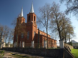
 Church in Adutiškis | |
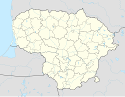
| Coordinates: 55°09′20″N 26°35′10″E / 55.15556°N 26.58611°E | |
| Country | |
| Ethnographic region | Aukštaitija |
| County | |
| Municipality | Švenčionys district municipality |
| Eldership | Adutiškis eldership |
| Population (2021) | |
• Total | 558 |
| Time zone | UTC+2 (EET) |
| • Summer (DST) | UTC+3 (EEST) |
Adutiškis (Lithuanian pronunciation: [adʊˈtʲɪʃkɪs]; Polish: Hoduciszki;[1] Belarusian: Гадуцішкі) is a town in Švenčionys district municipality, in Vilnius County, in northeast Lithuania. According to the 2011 census, the town has a population of 689 people.[2] The town is located near Kamaja river, and at the border with Belarus. There are the Church of St. Virgin Mary Scapular, built in 1913, Adutiškis Secondary School, customs office, post office and retirement home in Adutiškis
History
[edit]In autumn of 1941, the Jews from the town were taken to the Švenčionėliai military training ground and executed along with other Jews of the Švenčionys district.[3] This crime was perpetrated by an Einsatzgruppen of Adutiškis policemen.
References
[edit]- ^ Wykaz miejscowości Rzeczypospolitej Polskiej (in Polish). Vol. 1, Województwo wileńskie. GUS. 1938. p. 46.
- ^ "2011 census". Statistikos Departamentas (Lithuania). Retrieved August 4, 2017.
- ^ "Holocaust Atlas of Lithuania".


