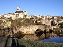
Bellac
Bellac | |
|---|---|
Subprefecture and commune | |
 Bridge over the Vincou | |
| Coordinates: 46°07′23″N 1°03′01″E / 46.1231°N 1.0503°E | |
| Country | France |
| Region | Nouvelle-Aquitaine |
| Department | Haute-Vienne |
| Arrondissement | Bellac |
| Canton | Bellac |
| Intercommunality | Haut Limousin en Marche |
| Government | |
| • Mayor (2020–2026) | Claude Peyronnet[1] |
| Area 1 | 24.42 km2 (9.43 sq mi) |
| Population (2021)[2] | 3,596 |
| • Density | 150/km2 (380/sq mi) |
| Time zone | UTC+01:00 (CET) |
| • Summer (DST) | UTC+02:00 (CEST) |
| INSEE/Postal code | 87011 /87300 |
| Elevation | 175–301 m (574–988 ft) (avg. 245 m or 804 ft) |
| 1 French Land Register data, which excludes lakes, ponds, glaciers > 1 km2 (0.386 sq mi or 247 acres) and river estuaries. | |
Bellac (French pronunciation: [bɛlak] ; Occitan: Belac [beˈlak]) is a commune in the Haute-Vienne department in the Nouvelle-Aquitaine region in western France.
Bellac is where the French author Jean Giraudoux, writer of L'Apollon de Bellac, was born in 1882. His house has been turned into a museum.
Geography
[edit]Bellac lies 45 km (28 mi) northwest of Limoges at the confluence of the rivers Gartempe and Vincou, in the Department of Haute-Vienne. Poitiers is 70 km (43 mi) to the northwest, and Angoulême 100 km (62 mi) to the southwest. The hills known as the Monts de Blond lie immediately to the south.
Administration
[edit]Bellac is a sous-préfecture of Haute-Vienne, seat of the arrondissement of Bellac which covers 57 communes. Furthernore, it is part of the canton of Bellac and of the communauté de communes Haut Limousin en Marche.[3]
Population
[edit]| Year | Pop. | ±% p.a. |
|---|---|---|
| 1968 | 5,240 | — |
| 1975 | 5,360 | +0.32% |
| 1982 | 5,079 | −0.77% |
| 1990 | 4,924 | −0.39% |
| 1999 | 4,576 | −0.81% |
| 2007 | 4,401 | −0.49% |
| 2012 | 4,211 | −0.88% |
| 2017 | 3,808 | −1.99% |
| Source: INSEE[4] | ||
Inhabitants are known as Bellachons in French.
Transport
[edit]Bellac is 30 km (19 mi) west of the A20 Limoges-Orléans motorway, and lies at a crossroads where the RN145 crosses the RN147. Both these roads had been designated part of the Route Centre-Europe Atlantique (RCEA) and were thus at risk of being upgraded to motorway. However, the latest thinking is that the RCEA will be re-routed from La Souterraine south down the A20 to Limoges and then via upgraded to the N520/N141 routes to Angoulême and the west.
Classifications
[edit]Bellac is classified as a cité de caractère, a village étape, a station verte de vacances, and a station touristique.
Notable people
[edit]- Jean Giraudoux (1882–1944), writer, dramatist and playwright, was born in Bellac
- Charles Silvestre (1889–1948), writer, winner of the Prix Femina in 1926, died in Bellac
See also
[edit]References
[edit]- ^ "Répertoire national des élus: les maires". data.gouv.fr, Plateforme ouverte des données publiques françaises (in French). 2 December 2020.
- ^ "Populations légales 2021" (in French). The National Institute of Statistics and Economic Studies. 28 December 2023.
- ^ Commune de Bellac (87011), INSEE
- ^ Population en historique depuis 1968, INSEE


