Le Transloy
- العربية
- Asturianu
- 閩南語 / Bân-lâm-gú
- Brezhoneg
- Català
- Cebuano
- Deutsch
- Eesti
- Español
- Euskara
- Français
- Bahasa Indonesia
- Italiano
- Қазақша
- Kurdî
- Latina
- Lëtzebuergesch
- Magyar
- Malagasy
- مصرى
- Bahasa Melayu
- Nederlands
- Нохчийн
- Occitan
- Picard
- Piemontèis
- Polski
- Português
- Română
- Simple English
- Slovenčina
- Svenska
- Татарча / tatarça
- Українська
- Vèneto
- Tiếng Việt
- Winaray
- Zazaki
- 中文
Appearance
From Wikipedia, the free encyclopedia
This is the current revision of this page, as edited by UrielAcosta (talk | contribs) at 23:21, 26 December 2024. The present address (URL) is a permanent link to this version.
Revision as of 23:21, 26 December 2024 by UrielAcosta (talk | contribs)
(diff) ← Previous revision | Latest revision (diff) | Newer revision → (diff)
Commune in Hauts-de-France, France
Le Transloy | |
|---|---|
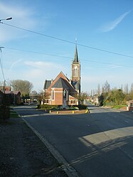
 The church of Le Transloy | |
| Coordinates: 50°03′36″N 2°53′39″E / 50.06°N 2.8942°E / 50.06; 2.8942 | |
| Country | France |
| Region | Hauts-de-France |
| Department | Pas-de-Calais |
| Arrondissement | Arras |
| Canton | Bapaume |
| Intercommunality | CC Sud-Artois |
| Government | |
| • Mayor (2020–2026) | Daniel Dhouailly[1] |
Area 1 | 10.41 km2 (4.02 sq mi) |
| Population (2022)[2] | 425 |
| • Density | 41/km2 (110/sq mi) |
| Time zone | UTC+01:00 (CET) |
| • Summer (DST) | UTC+02:00 (CEST) |
| INSEE/Postal code | 62829 /62450 |
| Elevation | 108–151 m (354–495 ft) (avg. 110 m or 360 ft) |
| 1 French Land Register data, which excludes lakes, ponds, glaciers > 1 km2 (0.386 sq mi or 247 acres) and river estuaries. | |
Le Transloy (French pronunciation: [lə tʁɑ̃lwa]) is a commune in the Pas-de-Calais department in the Hauts-de-France region of France[3] 18 miles (29 km) south of Arras.
Population
[edit]| Year | Pop. | ±% p.a. |
|---|---|---|
| 1968 | 447 | — |
| 1975 | 405 | −1.40% |
| 1982 | 399 | −0.21% |
| 1990 | 390 | −0.28% |
| 1999 | 371 | −0.55% |
| 2007 | 424 | +1.68% |
| 2012 | 417 | −0.33% |
| 2017 | 411 | −0.29% |
| Source: INSEE[4] | ||
See also
[edit]References
[edit]- ^ "Répertoire national des élus: les maires" (in French). data.gouv.fr, Plateforme ouverte des données publiques françaises. 13 September 2022.
- ^ "Populations de référence 2022" (in French). The National Institute of Statistics and Economic Studies. 19 December 2024.
- ^ INSEE commune file
- ^ Population en historique depuis 1968, INSEE
Wikimedia Commons has media related to Le Transloy.
| International | |
|---|---|
| National | |
This Arras arrondissement, Pas-de-Calais geographical article is a stub. You can help Wikipedia by expanding it. |
Hidden categories:
- Pages using gadget WikiMiniAtlas
- CS1 French-language sources (fr)
- Use dmy dates from August 2023
- Articles with short description
- Short description is different from Wikidata
- Coordinates on Wikidata
- Pages using infobox settlement with image map1 but not image map
- Pages with French IPA
- Commons category link from Wikidata
- All stub articles
- Pages using the Kartographer extension


