
Tachlovice

Tachlovice is a village in the Central Bohemian Region of the Czech Republic (in Prague-West District).
The village has an area of 6.36 square kilometres and 700 inhabitants as per the latest census. It is located on the south slope leading to Radotínský creek, part of the housing lies also on the right side from the creek. Tachlovice is member of the association of villages Jihozápad Region.
The village is the entry gate to the region of the Karlštejn Castle, and in the near vicinity, there is the spectacular quarry Velká Amerika, which, to many Czechs, resembles the Grand Canyon.
Places of historical interest
- Baroque church of St James the Great from 1742
- Graveyard chapel from 1745
- Former rectory
- Memorable tree in the near vicinity- White Willow (Salix alba), one of the largest of its kind in Bohemia with a shaft circuit of 665 cm (262 in).
-
 St James church, front view
 -
 St James church, side view
 -
 Graveyard chapel
 -
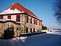 Former rectory


Interesting events
- Tachlovice triangle - this is a veteran cars exhibition and contest which is held once a year in memory of the founder Jan Horak. Many cars, including trucks, motorbikes manufactured until 1970s, are displayed near the village green and many of them later compete driving on the triangle route.

- In 2009, Tachlovice was commemorating 775 years of its first historical record - 14th of July 1234.
Tachlovice development
- The village has utility services now (electricity, gas, sewerage)
- In 2010, there will be a continued construction of new houses and apartment units in Tachlovice. The village is about to open the newly constructed tennis court and plans to start building a new footbal field.