Strochitsy
This article or section is in a state of significant expansion or restructuring. You are welcome to assist in its construction by editing it as well. If this article or section has not been edited in several days, please remove this template. If you are the editor who added this template and you are actively editing, please be sure to replace this template with {{in use}} during the active editing session. Click on the link for template parameters to use.
This article was last edited by DerBorg (talk | contribs) 13 years ago. (Update timer) |
Stročytsa / Stročitsy Строчыца / Сторчицы | |
|---|---|
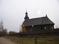
 The Church of Protection of Holy Virgin in the State Museum of Folk Architecture and Life | |
| Country Voblast Raion | |
| Founded | ? |
| Elevation | 280 m (920 ft) |
| Time zone | UTC+2 (EET) |
| • Summer (DST) | UTC+3 (EEST) |
| License plate | 5 |
Strochitsy (Belarusian: Строчыца, Strochytsa - Russian: Сторчицы), also named Strochitsy-Ozertso, is a village and municipality in Belarus, located in the Minsk Region. It is part of the Minsk Raion and the municipality includes the village of Ozertso (Belarusian: Азярцо, Azyartso - Russian: Озерцо)[1].
Geography
The municipality is located in western suburb of Minsk, and is part of its urban area. It is crossed by the river Ptsich and is few km far from Fanipol. Storchitsy village lies by the Volkovichskoye Lake, Ozertso is close to the Maskouski District of Minsk and to the beltway MKAD.
State Museum of Folk Architecture and Life
Between Strochitsy and Ozertso is located the Belarusian State Museum of Folk Architecture and Life[2][3], an open-air museum containing some models of the old and wood-made Belarusian farms, churchs and other structures.
References
- ^ Coordinates of Ozertso: 53°50′26.49″N 27°23′33.91″E / 53.8406917°N 27.3927528°E
- ^ Article on belarustourism.by
- ^ Coordinates of the museum: 53°49′46.89″N 27°22′25.51″E / 53.8296917°N 27.3737528°E
External links
![]() Media related to Strochitsy at Wikimedia Commons
53°49′10.89″N 27°21′54.12″E / 53.8196917°N 27.3650333°E
Media related to Strochitsy at Wikimedia Commons
53°49′10.89″N 27°21′54.12″E / 53.8196917°N 27.3650333°E

