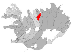
Hörgársveit
Appearance
Hörgársveit | |
|---|---|
Municipality | |
 Municipal location | |
| Country | |
| Constituency[1] | |
| Region[2] | |
| County | |
| Area | |
| • Total | 894 km2 (345 sq mi) |
| Population (2011) | |
| • Total | 600 |
| Time zone | UTC+0 (GMT) |
| Website | Official website |
Hörgársveit, also named Hörgárbyggð, is a municipality located in northern-central Iceland, in Norðurland vestra. As of 2011 its population was of 600.[3]
History
The former municipality of Hörgárbyggð was formed on 1st January 2001 by the union of the municipalities of Skriða (Skriðuhreppur), Öxnadalur (Öxnadalshreppur) and Glæsibær (Glæsibæjarhreppur). In 2010 Hörgárbyggð merged with Arnarnes to form the actual municipality.
Geography
Located on the Eyjafjörður, in north of Akureyri, Hörgársveit is formed by several villages, mainly Lónsbakki (115 inh.) and Hjalteyri (37 inh.), the seat of the former municipality of Arnarnes.
References
- ^ Political division
- ^ Mainly statistical division
- ^ Statistics Iceland - Population of Municipalities
External links
