Ururi
Appearance
Ururi | |
|---|---|
| Comune di Ururi | |
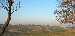
 Panorama of Ururi | |
| Country | Italy |
| Region | Molise |
| Province | Campobasso (CB) |
| Government | |
| • Mayor | Luigi Plescia |
| Area | |
| • Total | 31.5 km2 (12.2 sq mi) |
| Elevation | 262 m (860 ft) |
| Population | |
| • Total | 2,871 |
| • Density | 91/km2 (240/sq mi) |
| Demonym | Ururesi |
| Time zone | UTC+1 (CET) |
| • Summer (DST) | UTC+2 (CEST) |
| Postal code | 86049 |
| Dialing code | 0874 |
| Website | Official website |
Ururi is a comune (municipality) in the Province of Campobasso in the Italian region Molise, located about 40 km northeast of Campobasso.
Ururi borders the following municipalities: Larino, Montorio nei Frentani, Rotello, San Martino in Pensilis.
Wikimedia Commons has media related to Ururi.
References
- ^ "Superficie di Comuni Province e Regioni italiane al 9 ottobre 2011". Italian National Institute of Statistics. Retrieved 16 March 2019.
- ^ All demographics and other statistics: Italian statistical institute Istat.
- ^ "Popolazione Residente al 1° Gennaio 2018". Italian National Institute of Statistics. Retrieved 16 March 2019.


