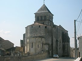
Chaniers
Appearance
You can help expand this article with text translated from the corresponding article in French. (December 2008) Click [show] for important translation instructions.
|
Chaniers | |
|---|---|
 | |
| Country | France |
| Region | Nouvelle-Aquitaine |
| Department | Charente-Maritime |
| Arrondissement | Saintes |
| Canton | Saintes-Est |
| Government | |
| • Mayor (2008–2014) | Xavier de Roux |
Area 1 | 26.53 km2 (10.24 sq mi) |
| Population (2008) | 3,391 |
| • Density | 130/km2 (330/sq mi) |
| Time zone | UTC+01:00 (CET) |
| • Summer (DST) | UTC+02:00 (CEST) |
| INSEE/Postal code | 17086 /17610 |
| Elevation | 2–74 m (6.6–242.8 ft) |
| 1 French Land Register data, which excludes lakes, ponds, glaciers > 1 km2 (0.386 sq mi or 247 acres) and river estuaries. | |
Chaniers is a commune in the Charente-Maritime department in southwestern France.
Population
| Year | 1793 | 1800 | 1806 | 1821 | 1831 | 1836 | 1841 | 1846 | 1851 | 1856 |
|---|---|---|---|---|---|---|---|---|---|---|
| Population | 2387 | 2122 | 1922 | 2532 | 2719 | 2733 | 2530 | 2522 | 2611 | 2556 |
| Year | 1861 | 1866 | 1872 | 1876 | 1881 | 1886 | 1891 | 1896 | 1901 | 1906 |
|---|---|---|---|---|---|---|---|---|---|---|
| Population | 2563 | 2565 | 2309 | 2233 | 2151 | 2260 | 2115 | 2029 | 2003 | 2004 |
| Year | 1911 | 1921 | 1926 | 1931 | 1936 | 1946 | 1954 | 1962 | 1968 | 1975 |
|---|---|---|---|---|---|---|---|---|---|---|
| Population | 1910 | 1809 | 1732 | 1694 | 1723 | 1934 | 1955 | 2022 | 2255 | 2750 |
| Year | 1982 | 1990 | 1999 | 2008 |
|---|---|---|---|---|
| Population | 2960 | 3086 | 3232 | 3391 |
See also
References

