
Rømø
 | |
| Geography | |
|---|---|
| Location | Wadden Sea |
| Coordinates | 55°08′N 8°31′E / 55.133°N 8.517°E |
| Area | 129 km2 (50 sq mi) |
| Administration | |
Denmark | |
| Demographics | |
| Population | 650 |
| Pop. density | 5.3/km2 (13.7/sq mi) |

Rømø (German: Röm, Frisian: Romeach) is a Danish island in the Wadden Sea. Rømø is part of Tønder municipality. The island has 650 inhabitants as of 1 January 2011[1] and covers an area of 129 km². Rømø is a popular tourist spot each year, attracted by the clothing optional beaches which can be driven on with motor vehicles legally.
Rømø is now the southernmost of Denmark's Wadden Sea Islands (the previous being the small uninhabited island of Jordsand which sank in 1999). It is linked to the Danish mainland by a road running across a causeway, and the island also lies only about 3 km from the neighbouring German island Sylt, to which it is connected by ferry. It is home to a number of small communities such as Kongsmark, Østerby, Lakolk, and Sønderstrand.
From 1864 until 1920, Rømø belonged to Germany and was part of the Prussian province of Schleswig-Holstein.
See also
- List of Danish islands
- Nearby islands: Mandø, Fanø, Sylt (German island).
- Nearby towns: Esbjerg, Ribe, Skærbæk, Tønder
Notes
- ^ "Danmarks Statistik." Retrieved 11 June 2010.
Gallery
-
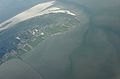 Aerial view
 -
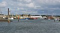 Harbour
 -
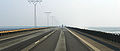 Causeway
 -
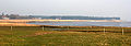 shore
shore


External links
| Baltic Sea | ||
|---|---|---|
| Sydhavsøerne | ||
| Kattegat | ||
| South Funen Archipelago | ||
| Limfjorden | ||
| Øresund | ||
| Great Belt | ||
| Little Belt | ||
| Wadden Sea | ||
| Other islands |
| |
| West Frisian Islands (Netherlands) |
|  | |||||
|---|---|---|---|---|---|---|---|
| East Frisian Islands (Germany) |
| ||||||
| Heligoland Bight (Germany) | |||||||
| North Frisian Islands (Germany) |
| ||||||
| Danish Wadden Sea Islands (Denmark) |
| ||||||
This Danish location article is a stub. You can help Wikipedia by expanding it. |