
Sandoy
Sandoy
Sandø | |
|---|---|
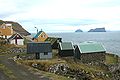
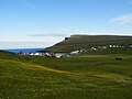
 Sandur on the Island of Sandoy - view from the bay Sandsvágur in the Southeast | |
 Location within the Faroe Islands | |
| State | Kingdom of Denmark |
| Autonomous country | Faroe Islands |
| Area | |
| • Total | 125 km2 (48 sq mi) |
| Population (2001) | |
| • Total | 1,494 |
| • Density | 12/km2 (31/sq mi) |
| Time zone | UTC+0 (GMT) |
| • Summer (DST) | UTC+1 (EST) |
| Calling code | 298 |
Sandoy (Danish: Sandø. English: Sandisland) is the first of the five southern islands that make up the Faroe chain, the fifth biggest of all the Faroe Islands,[1] an autonomous region of the Kingdom of Denmark. As of 2011[update], the largest population center on the island is the village of Sandur with a population of 599.[2] Other settlements include Skarvanes, Skopun, Skálavík, Húsavík and Dalur.
Sandoy gets its name from the large beach at Sandur, and the general sandy soil of the island. It is the only island with dunes.
There are similarly named islands, Sanday in the Orkney Islands, Sanday in the Inner Hebrides and Sandøy in Norway.
A proposal has been approved by the Faroese parliament to build a tunnel connecting Sandoy with the more populous Streymoy to the north. Construction is not intended to be completed until 2021.
Important Bird Areas
The island's surrounding bird cliffs and steep slopes have been identified as an Important Bird Area (IBA) by BirdLife International because of their significance as a breeding site for seabirds, especially northern fulmars (50,000 pairs), Manx shearwaters (5000 pairs), European storm petrels (50,000 pairs), European shags (150 pairs), great skuas (15 pairs), Atlantic puffins (70,000 pairs) and black guillemots (400 pairs).[3] An additional IBA on the island comprises the lowland areas around the village of Sandur, with their moorland and peat bogs, and the lakes Gróthúsvatn, Lítlavatn, Sandsvatn and Stóravatn, because they support 100-150 breeding pairs of whimbrels.[4]
See also
Further reading
- Jørgensen, Gunni, and Jóannes Rasmussen. Glacial Striae, Roches Moutonnées, and Ice Movements on Sandoy (Faeroe Islands). Communications géologiques, no 314. [Copenhagen, Denmark]: Muséum de minéralogie et de géologie de l'Université de Copenhague, 1978.
- Lawson, Ian, et al. 2005. "Historical Ecology on Sandoy, Faroe Islands: Palaeoenvironmental and Archaeological Perspectives". Human Ecology. 33, no. 5: 651-684.
Gallery
-
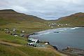
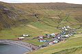
 Skarvanes
 -
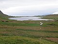 The lake Sandsvatn is the largest on the island and the third largest in the Faroe Islands.
 -
-
-
-


.JPG?lang=en)
.JPG?lang=en)


References
- ^ Proctor, James (2008). Faroe Islands. Bradt Travel Guides. p. 133. ISBN 1-84162-224-9.
- ^ Visit Sandoy. "Sandoy". The Tourist Information Center in Sandoy. Retrieved 4 December 2011.
- ^ BirdLife International. (2012). Important Bird Areas factsheet: Sandoy. Downloaded from Birdlife.org on 2012-02-23.
- ^ BirdLife International. (2012). Important Bird Areas factsheet: Vøtnini á Sandoy (Lakes of Sandoy). Downloaded from Birdlife.org on 2012-02-23.