Motavita
Appearance
Motavita | |
|---|---|
Municipality and town | |
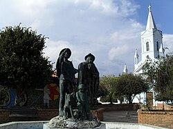
 Central square of Motavita | |
 Location of the municipality and town of Motavita in the Boyacá Department of Colombia | |
| Country | |
| Department | Boyacá Department |
| Province | Central Boyacá Province |
| Founded | 23 December 1816 |
| Government | |
| • Mayor | Heli Quintero Suárez (2016-2019) |
| Area | |
| • Municipality and town | 62 km2 (24 sq mi) |
| Elevation | 2,690 m (8,830 ft) |
| Population (2015) | |
| • Municipality and town | 8,067 |
| • Urban | 881 |
| Time zone | UTC-5 (Colombia Standard Time) |
| Website | Official website |
Motavita is a town and municipality in the Colombian Department of Boyacá, part of the subregion of the Central Boyacá Province. It covers approximately 62 square kilometres (24 sq mi).[1]
Etymology
The name Motavita comes from the Chibcha language and means "washing place to prepare for growing crops", indicating a ceremonial use.[2]
Geography
Motavita is bordered to the north by Arcabuco and Cómbita, to the east and south by Tunja, and to the west by Sora and Chíquiza.[3]
Divisions
Motavita was divided into five cadastral vereda (townships): Centro, Carbonera, Ristá, Salvial and Sote Panelas; however, Sote Panelas had four more veredas split off from it, namely: Frutillal, Versalles, Quebrada Honda and Barro Hondo, thus making nine vereda.[4]
Born in Motavita
- Jefferson Vargas, professional cyclist
References
- ^ Template:Es Official website Motavita
- ^ López, Javier Ocampo (2001). El imaginario en Boyacá: la identidad del pueblo boyacense y su proyección en la simbología regional (Volume 2: El imaginario colectivo en los pensadores boyacenses). Bogotá, Colombia: Universidad Distrital "Francisco José de Caldas". p. 84. ISBN 978-958-9160-90-9.
- ^ "Motavita: Generalidades: 1.2 Limites (Motavita: Overview: 1.2 Borders)" (PDF) (in Spanish). Government of Boyacá. p. 1.
{{cite web}}: Cite has empty unknown parameter:|1=(help) - ^ "Motavita: Generalidades: 1.3 División Política (Veredas)" (PDF) (in Spanish). Government of Boyacá. p. 4.
{{cite web}}: Cite has empty unknown parameter:|1=(help)


