Peranzanes
Appearance
Peranzanes | |
|---|---|
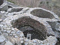
 Rests of the Castro de Chano | |
| Country | |
| Autonomous community | |
| Province | |
| Comarca | |
| Area | |
| • Total | 117 km2 (45 sq mi) |
| Population (2004) | |
| • Total | 329 |
| • Density | 2.8/km2 (7/sq mi) |
| Time zone | UTC+1 (CET) |
| • Summer (DST) | UTC+2 (CEST) |
| Climate | Csb |
Peranzanes is a village and municipality located in the region of El Bierzo (province of León, Castile and León, Spain). According to the 2004 census (INE), the municipality has a population of 329 inhabitants.
Geography
Peranzanes counts the hamlets (pueblos) of Cariseda, Chano, Faro, Fresnedelo, Guimara and Trascastro.
See also
External links
![]() Media related to Peranzanes at Wikimedia Commons
Media related to Peranzanes at Wikimedia Commons
42°53′N 6°38′W / 42.883°N 6.633°W


