
Civic Center, San Francisco
Civic Center
UN Plaza | |
|---|---|
| San Francisco Civic Center Historic District | |
 Civic Center Location within Central San Francisco | |
| Coordinates: 37°46′45″N 122°24′57″W / 37.77917°N 122.41583°W | |
| Government | |
| • Supervisor | Jane Kim and London Breed ( block bounded by Van Ness, Turk, Golden Gate Ave., & Franklin ). |
| • State Assembly | Matt Haney (D)[1] |
| • State Senator | Scott Wiener (D)[1] |
| • U. S. Rep. | Barbara Lee (D)[2] |
| Area | |
| • Total | 1.27 km2 (0.492 sq mi) |
| • Land | 1.27 km2 (0.492 sq mi) |
| Population (2008) | |
| • Total | 10,101 |
| • Density | 7,925/km2 (20,525/sq mi) |
| [3] | |
| ZIP codes | 94102, 94109 |
| Area codes | 415/628 |
| [3] | |
San Francisco Civic Center Historic District | |
 San Francisco Civic Center, looking west along UN Plaza to City Hall | |
| Location | Roughly bounded by Golden Gate Ave., 7th, Franklin, Hayes, and Market Sts., San Francisco, California |
| Area | 45.6 acres (18.5 ha) |
| Built | 1912[5] |
| Architectural style | Late 19th and 20th Century revivals Beaux-Arts |
| NRHP reference No. | 78000757[4] |
| Significant dates | |
| Added to NRHP | October 10, 1978[4] |
| Designated NHLD | February 27, 1987[6] |
The Civic Center in San Francisco, California, is an area of a few blocks north of the intersection of Market Street and Van Ness Avenue that contains many of the city's largest government and cultural institutions. It has two large plazas (Civic Center Plaza and United Nations Plaza) and a number of buildings in classical architectural style. The Bill Graham Civic Auditorium (formerly the Exposition Auditorium),[5] the United Nations Charter was signed in the War Memorial Veterans Building's Herbst Theatre in 1945, leading to the creation of the United Nations. It is also where the 1951 Treaty of San Francisco (the peace treaty that officially ended the Pacific War with the Empire of Japan, which had surrendered in 1945) was signed. The San Francisco Civic Center was designated a National Historic Landmark in 1987[6] and listed in the National Register of Historic Places on October 10, 1978.[4]
Location
The Civic Center is bounded by Market Street to the southeast, Franklin Street to the west, Turk Street to the north, and Leavenworth Street, McAllister Street, and Charles J. Brenham Place to the east. The Civic Center borders the Tenderloin neighborhood on the north and east and the Hayes Valley neighborhood on the west; Market Street separates it from the South of Market, or "SoMa", neighborhood.
History
The Civic Center was built in the early 20th century after an earlier city hall was destroyed in the 1906 earthquake and fire. Although the architect and urban planner Daniel Burnham had provided the city with plans for a neo-classical Civic Center shortly before the 1906 earthquake, his plans were never carried out. A temporary city hall was put up on Market Street, but planning for a more permanent structure and civic center did not take place for several years. The current civic center was planned by a group of local architects, chaired by John Galen Howard.[7]
The current City Hall was completed in 1915, in time for the Panama-Pacific Exposition. The War Memorial Opera House and its neighboring twin, the War Memorial Veterans Building (which together were the nucleus of the San Francisco War Memorial and Performing Arts Center), the Main Library, and the State and Old Federal buildings would be built later, during the 1920s and 1930s.
During World War II, Army barracks and Victory gardens were constructed in the main plaza in front of City Hall and the Library. The 1950s through the 1970s and 1980s saw tall post-modernist Federal and State buildings constructed in the area; an underground exhibition facility, Brooks Hall, was built beneath the Civic Center Plaza in 1958. The Louise M. Davies Symphony Hall and Harold L. Zellerbach Rehearsal Hall were added in 1980. The 1990s saw the construction of a new Main Library with the conversion of the old Main Library building into the Asian Art Museum, and the removal of all public benches. In 1998, the city officially renamed part of the plaza the Joseph L. Alioto Performing Arts Piazza after the former mayor.
Its central location, vast open space, and the collection of government buildings have made and continue to make Civic Center the scene of massive political rallies. It has been the scene of massive anti-war protests and rallies since the Korean War. It was also the scene of major moments of the Gay Rights Movement. Activist Harvey Milk held rallies and gave speeches there. After his assassination on November 27, 1978, a massive candlelight vigil was held there. Later, it was the scene of the White Night Riots in response to the lenient sentencing of Dan White, Milk's assassin. Recently, Civic Center was the center point of same-sex marriage activism, as Mayor Gavin Newsom married couples there.
Attractions and characteristics

- Government
- Monuments
- Culture
- Parks and open spaces
- Transit stops
- Education
Government center
The centerpiece of the Civic Center is the City Hall, which heads the complex and takes up two city blocks on Polk Street. The section of the street in front of the building was renamed for Dr. Carlton B. Goodlett, a local African American activist. Across the street on McAllister Street is the headquarters of the Supreme Court of California. Across from that building is the Asian Art Museum, opened in 2004 in the former main branch building of the San Francisco Public Library, which moved to a newer building constructed just south of Fulton in 1995.
North of City Hall is the Phillip Burton Federal Building and United States Courthouse for the United States District Court for the Northern District of California, and State of California office buildings. This includes offices of several federal agencies, including the Federal Bureau of Investigation San Francisco Field Office.[8] East of the main Civic Center complex on nearby Mission Street, is the head courthouse of the United States Court of Appeals for the Ninth Circuit which sits across 7th from the San Francisco Federal Building complex.
Monuments
The Pioneer Monument, funded by the estate of James Lick and dedicated to Manifest Destiny, is located in the middle of Fulton Street between the Library and the Asian Art Museum. The section of Fulton Street between Hyde and Leavenworth streets was pedestrianized and re-developed into United Nations Plaza in 1975 as a monument for the United Nations and the signing of the UN Charter, when the Bay Area Rapid Transit subway was constructed under Market Street. The 2.6-acre (11,000 m2) pedestrian mall was designed by Lawrence Halprin.[9] It was rededicated in June 1995 by visiting members of the UN General Assembly as part of its 60th anniversary, and renovated and rededicated again in 2005 during the World Environment Day event. Currently, it is the site of a small farmers' market as well as a replica of a large equestrian statue of Simon Bolivar.
Culture
West of City Hall on Van Ness Avenue is the War Memorial Opera House, where the U.N. Charter was signed in 1945 and the Treaty of San Francisco was signed in 1951. Davies Symphony Hall is south of the Opera House; to its north is the War Memorial Veterans Building, which contains the Herbst Theatre. The Bill Graham Civic Auditorium and SHN Orpheum Theatre are also located in Civic Center.
Parks and open spaces
The main open space just east of City Hall is Civic Center Plaza. Despite the area's seedy reputation due to its proximity to the Tenderloin, its central location also makes it the center of many of the City's festivals and parades. Many street parades and parties are held in Civic Center Plaza, including San Francisco's Gay Pride Parade, the City's Earth Day celebration (which attracts 15,000+ people), the St. Patrick's Day parade, San Francisco's version of the Love Parade, and the San Francisco LovEvolution party.
Renovated and re-opened on February 15, 2018 the Helen Diller Civic Center Playgrounds reside on the Northeast and Southeast corners of the Civic Center Plaza.[10] The San Francisco Parks and Recreation program partnered with The Trust for Public Land to renovate the 20 year old playgrounds.[11] The playgrounds were funded by a generous $10 million donation from the Helen Diller Family Foundation.[10][11][12] The playgrounds serve many surrounding neighborhoods with limited open space such as the Tenderloin, Western Addition, Hayes Valley, and South of Market neighborhoods.[11]
Transit
Access to Civic Center is provided by the Civic Center Station on Market, a subway stop for both BART and the Muni Metro. The F Market historic streetcar line and many Muni bus lines also run nearby.
Education
Civic Center is the site of four famous higher education schools: Minerva Schools at KGI, the University of California, Hastings College of the Law, the private The Art Institute of California – San Francisco and The San Francisco Conservatory of Music. UC Hastings is located on the two blocks straddling Hyde between Golden Gate and McAllister. Academy of Art University owns two buildings in the neighborhood, and the buildings are used primarily for academic and administrative purposes.[13]
Reputation
Civic Center is adjacent to the skid row Tenderloin neighborhood, so it has a seedy, run-down, high-crime reputation and appearance with large numbers of homeless encampments, which have prevented it from attracting the large numbers of tourists seen in other areas of the city. Despite repeated redevelopment of Civic Center over the years aimed primarily at discouraging the homeless from camping there, large numbers of homeless people continue to camp and socialise in the area.
Other points of interest
The Fox Plaza condominium complex is also located nearby. The large art installation Firefly by Ned Kahn can be seen on the side of the San Francisco Public Utilities Commission building on Golden Gate Avenue.
In December 2010, a set of innovative wind and solar hybrid streetlamps provided by Urban Green Energy were installed[14] as part of the center's vision for sustainability.
Selected photos

-
-
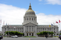
 City Hall
 -
 Ronald M. George State Office Complex: Earl Warren Building with the Hiram W. Johnson State Office Building behind
 -
-

-
-

-
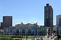
 Farmers' market at United Nations Plaza
 -

-
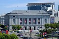
 Department of Public Health
 -
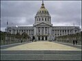 Civic Center Plaza with San Francisco City Hall in the background, April 2009


.JPG?lang=en)


.JPG?lang=en)

.JPG?lang=en)
.JPG?lang=en)

See also
References
- ^ a b "Statewide Database". UC Regents. Retrieved December 8, 2014.
- ^ "California's 12th Congressional District - Representatives & District Map". Civic Impulse, LLC.
- ^ a b c [1]
- ^ a b c "National Register Information System". National Register of Historic Places. National Park Service. July 9, 2010.
- ^ a b Charleton, James P. (November 9, 1984). "San Francisco Civic Center" (pdf). National Register of Historic Places - Inventory Nomination Form. National Park Service. Retrieved 20 May 2012.
- ^ a b "San Francisco Civic Center". National Historic Landmark Quicklinks. National Park Service. Retrieved 20 March 2012.
- ^ William Issel and Robert Cherny, _San Francisco, 1865-1932_, pp. 170-171.
- ^ "San Francisco Division." Federal Bureau of Investigation. Retrieved on June 9, 2015. "450 Golden Gate Avenue, 13th Floor San Francisco, CA 94102-9523"
- ^ 2.6 acres, 1975, part of BART construction, Halprin as designer Archived 2007-09-27 at the Wayback Machine
- ^ a b "$10 million playgrounds give downtown SF kids a safe place to frolic". SFChronicle.com. 2018-02-16. Retrieved 2018-08-01.
- ^ a b c "Helen Diller Playgrounds at Civic Center Improvements | San Francisco Recreation and Park". sfrecpark.org. Retrieved 2018-08-01.
- ^ "Helen Diller Civic Center Playgrounds". The Trust for Public Land. Retrieved 2018-08-01.
- ^ "Academy of Art University Campus Map" (PDF). academyart.edu. Academy of Art University. Retrieved 23 November 2016.
- ^ Hybrid Street Lamp Hits San Francisco Archived 2010-12-20 at the Wayback Machine
External links
- Photo tour of Civic Center A photo tour of Civic Center complete with narrative text.
- "San Francisco Civic Center" (pdf). Photographs. National Park Service. Retrieved 20 May 2012.
- The architects
- Earth Day SF San Francisco's very well attended Earth Day celebration.
| Buildings and business |
| ||||||||
|---|---|---|---|---|---|---|---|---|---|
| Geography | |||||||||
| Public art | |||||||||
| Transportation | |||||||||
| Downtown |  | |
|---|---|---|
| North of Downtown | ||
| Outside Lands | ||
| Western Addition | ||
| Southern | ||
| Topics | |
|---|---|
| Lists by state |
|
| Lists by insular areas | |
| Lists by associated state | |
| Other areas | |
| Related | |
- Civic Center, San Francisco
- Neighborhoods in San Francisco
- Historic districts on the National Register of Historic Places in California
- History of San Francisco
- Landmarks in San Francisco
- National Historic Landmarks in the San Francisco Bay Area
- National Register of Historic Places in San Francisco
- San Francisco Designated Landmarks