Chicxulub Pueblo
Chicxulub Pueblo | |
|---|---|
Municipal Seat | |
 | |
| Coordinates: 21°8′11″N 89°31′0″W / 21.13639°N 89.51667°W | |
| Country | |
| State | Yucatán |
| Municipality | Chicxulub Pueblo |
| Elevation | 8 m (26 ft) |
| Population (2010) | |
| • Total | 4,080[1] |
| Time zone | UTC−6 (Central Standard Time) |
| • Summer (DST) | UTC−5 (Central Daylight Time) |
| Postal code | 97340 |
| Area code | 985 |
| INEGI code | 310200001 |
Chicxulub Pueblo (Mayan pronunciation: [tʃʼikʃuluɓ] Ch’ik Xulub) is a town, and surrounding municipality of the same name, in the Mexican state of Yucatán.
At the census of 2010, the town had a population of 4,080 people

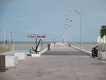
Chicxulub is most famous for being near the geographic center of the Chicxulub crater, an impact crater discovered by geologists on the Yucatán Peninsula and extending into the ocean. It was created by the impact some 66 million years ago of the Chicxulub impactor, an asteroid or comet which caused[2][3] the Cretaceous–Paleogene extinction event, which led to the extinction of all non-avian dinosaurs. The coastal village (or puerto) of Chicxulub, 6 km east of the nearest town, Progreso, lies almost exactly on the geographic center of the crater.
The name Chicxulub is from the Yucatec Maya language, where ch’ik means "flea" or "tick", and xulub’ means "devil, demon, or horns".[4]
Climate
Chicxulub Puerto has a hot semi-arid climate (Köppen Aw). Chicxulub has warm weather year round with dry winters and sometimes wet summers.
Chixulub Puerto's highest temperature was 43.0 °C (109.4 °F) was on multiple dates, most recent on September 16, 2004. The lowest was 8.5 °C (47.3 °F) on January 9, 2003.
| Climate data for Chicxulub Puerto (normals 1981-2010) | |||||||||||||
|---|---|---|---|---|---|---|---|---|---|---|---|---|---|
| Month | Jan | Feb | Mar | Apr | May | Jun | Jul | Aug | Sep | Oct | Nov | Dec | Year |
| Record high °C (°F) | 39.5 (103.1) |
38.0 (100.4) |
41.0 (105.8) |
43.0 (109.4) |
43.0 (109.4) |
42.5 (108.5) |
40.0 (104.0) |
39.0 (102.2) |
43.0 (109.4) |
40.0 (104.0) |
38.0 (100.4) |
37.0 (98.6) |
43.0 (109.4) |
| Mean daily maximum °C (°F) | 26.9 (80.4) |
28.0 (82.4) |
29.6 (85.3) |
31.1 (88.0) |
32.2 (90.0) |
32.1 (89.8) |
31.7 (89.1) |
31.8 (89.2) |
31.6 (88.9) |
30.4 (86.7) |
29.0 (84.2) |
27.5 (81.5) |
30.2 (86.3) |
| Daily mean °C (°F) | 22.5 (72.5) |
23.3 (73.9) |
24.5 (76.1) |
25.8 (78.4) |
27.2 (81.0) |
27.4 (81.3) |
27.2 (81.0) |
27.3 (81.1) |
27.2 (81.0) |
26.1 (79.0) |
24.6 (76.3) |
23.0 (73.4) |
25.5 (77.9) |
| Mean daily minimum °C (°F) | 18.0 (64.4) |
18.5 (65.3) |
19.3 (66.7) |
20.6 (69.1) |
22.3 (72.1) |
22.8 (73.0) |
22.7 (72.9) |
22.7 (72.9) |
22.7 (72.9) |
21.9 (71.4) |
20.2 (68.4) |
18.6 (65.5) |
20.9 (69.6) |
| Record low °C (°F) | 8.5 (47.3) |
9.0 (48.2) |
10.0 (50.0) |
11.0 (51.8) |
15.0 (59.0) |
16.0 (60.8) |
15.0 (59.0) |
14.0 (57.2) |
15.0 (59.0) |
13.0 (55.4) |
12.0 (53.6) |
10.0 (50.0) |
8.5 (47.3) |
| Average precipitation mm (inches) | 44.1 (1.74) |
32.2 (1.27) |
26.6 (1.05) |
21.2 (0.83) |
33.1 (1.30) |
115.9 (4.56) |
68.3 (2.69) |
58.0 (2.28) |
130.4 (5.13) |
94.8 (3.73) |
42.7 (1.68) |
30.1 (1.19) |
697.4 (27.45) |
| Average precipitation days | 3.7 | 2.9 | 1.9 | 1.5 | 2.8 | 7.3 | 6.3 | 5.7 | 8.1 | 7.2 | 4.0 | 3.2 | 54.6 |
| Source: Servicio Meteorologico Nacional [5] | |||||||||||||
References
- ^ "Population and Housing Census 2010". INEGI.org. National Institute of Statistics and Geography. 2010. Retrieved 5 July 2018.
- ^ "International Consensus—Link Between Asteroid Impact and Mass Extinction Is Rock Solid". Lunar and Planetary Institute. 2010-03-04. Retrieved 2014-11-27.
- ^ Renne, Paul R.; Deino, Alan L.; Hilgen, Frederik J.; Kuiper, Klaudia F.; Mark, Darren F.; Mitchell, William S.; Morgan, Leah E.; Mundil, Roland; Smit, Jan (7 February 2013). "Time Scales of Critical Events Around the Cretaceous-Paleogene Boundary". Science. 339 (6120): 684–687. Bibcode:2013Sci...339..684R. doi:10.1126/science.1230492. PMID 23393261.
- ^ Victoria Bricker (1998). A Dictionary of the Maya Language as Spoken in Hocabá, Yucatán.
- ^ "Servicio Meteorologico Nacional (Mexico)". Retrieved 2 September 2020.
External links
- Link to tables of population data from Census of 2005 INEGI: Instituto Nacional de Estadística, Geografía e Informática
- Google Maps
- Google Earth seashore view at Chicxulub


