Banwa Province
Appearance
Banwa | |
|---|---|
Province | |
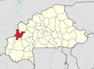
 Location in Burkina Faso | |
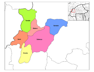
 Provincial map of its departments | |
| Country | |
| Region | Boucle du Mouhoun |
| Capital | Solenzo |
| Area | |
| • Total | 2,271 sq mi (5,882 km2) |
| Population (2019 census)[1] | |
| • Total | 345,749 |
| • Density | 150/sq mi (59/km2) |
| Time zone | UTC+0 (GMT 0) |
Banwa is one of the 45 provinces of Burkina Faso and is in Boucle du Mouhoun Region. The capital of Banwa is Solenzo. In 2019 it had a population of 345,749.
Education
In 2011 the province had 170 primary schools and 13 secondary schools.[2]
Healthcare
In 2011 the province had 23 health and social promotion centers (Centres de santé et de promotion sociale), 3 doctors and 87 nurses.[3]
Demographics
It is a rural province with 255,337 of its residents living in the countryside; only 12,597 live in urban areas. There are 131,100 men living in Bam Province and 136,834 women.[4]
Departments
Banwa is divided into 6 departments:
| Departments | Capitals | Population (Census 2006)[4] |
|---|---|---|
| Balavé Department | Balavé | 16,412 |
| Kouka Department | Kouka | 59,588 |
| Sami Department | Sami | 8,684 |
| Sanaba Department | Sanaba | 34,166 |
| Solenzo Department | Solenzo | 118,424 |
| Tansila Department | Tansila | 30,660 |
See also
References
- ^ Citypopulation.de Population of provinces in Boucle du Mouhoun Region
- ^ "La région du Boucle du Mouhoun en chiffres" (PDF). Institut National de la Statistique et de la Démographie (INSD). 2011. p. 6. Archived from the original (PDF) on 2012-11-13.
- ^ "La région du Boucle du Mouhoun en chiffres" (PDF). Institut National de la Statistique et de la Démographie (INSD). 2011. p. 6. Archived from the original (PDF) on 2012-11-13.
- ^ a b "National 2006 census preliminary results" (PDF). Archived from the original (PDF) on 2015-07-21. Retrieved 2008-05-27.
12°10′N 4°10′W / 12.167°N 4.167°W
