Benafarces
Appearance
Benafarces, Spain | |
|---|---|
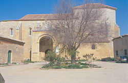
 Church of Asunción | |
| Country | Spain |
| Autonomous community | Castile and León |
| Province | Valladolid |
| Municipality | Benafarces |
| Area | |
| • Total | 16.65 km2 (6.43 sq mi) |
| Elevation | 743 m (2,438 ft) |
| Population (2018)[1] | |
| • Total | 68 |
| • Density | 4.1/km2 (11/sq mi) |
| Time zone | UTC+1 (CET) |
| • Summer (DST) | UTC+2 (CEST) |
Benafarces is a municipality located in the province of Valladolid, Castile and León, Spain. According to the 2004 census (INE), the municipality had a population of 114 inhabitants.
In 1147 Osorio Martínez granted a fuero to Benafarces with the approval of Alfonso VII. The village in turn was required to make an annual payment in kind of half a sheep, ten loaves of bread, some barley, and some must.[2]
Notes
- ^ Municipal Register of Spain 2018. National Statistics Institute.
- ^ Simon Barton, The Aristocracy in Twelfth-century León and Castile (Cambridge: Cambridge University Press, 1997), 95.


