Châtelperron
Appearance
You can help expand this article with text translated from the corresponding article in French. (December 2008) Click [show] for important translation instructions.
|
Châtelperron | |
|---|---|
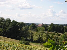
 A general view of Châtelperron | |
| Coordinates: 46°23′59″N 3°38′14″E / 46.3997°N 3.6372°E | |
| Country | France |
| Region | Auvergne-Rhône-Alpes |
| Department | Allier |
| Arrondissement | Vichy |
| Canton | Moulins-2 |
| Government | |
| • Mayor (2020–2026) | Maria Schneider[1] |
| Area 1 | 20.8 km2 (8.0 sq mi) |
| Population (2021)[2] | 133 |
| • Density | 6.4/km2 (17/sq mi) |
| Time zone | UTC+01:00 (CET) |
| • Summer (DST) | UTC+02:00 (CEST) |
| INSEE/Postal code | 03067 /03220 |
| Elevation | 234–352 m (768–1,155 ft) (avg. 253 m or 830 ft) |
| 1 French Land Register data, which excludes lakes, ponds, glaciers > 1 km2 (0.386 sq mi or 247 acres) and river estuaries. | |
Châtelperron (French pronunciation: [ʃatɛlpɛʁɔ̃]) is a commune in the central French department of Allier.
It is the location of the site known as La Grotte des Fées.[3][4][5][6]
Population
| Year | Pop. | ±% p.a. |
|---|---|---|
| 1968 | 287 | — |
| 1975 | 250 | −1.95% |
| 1982 | 219 | −1.87% |
| 1990 | 189 | −1.82% |
| 1999 | 137 | −3.51% |
| 2007 | 141 | +0.36% |
| 2012 | 155 | +1.91% |
| 2017 | 146 | −1.19% |
| Source: INSEE[7] | ||
See also
References
- ^ "Répertoire national des élus: les maires" (in French). data.gouv.fr, Plateforme ouverte des données publiques françaises. 13 September 2022.
- ^ "Populations légales 2021" (in French). The National Institute of Statistics and Economic Studies. 28 December 2023.
- ^ Montagu, M. F. Ashley (1949). "The Châtelperron Skull; A Rediscovered Human Skull-Cap from the French Early Upper Palaeolithic". American Anthropologist. 51 (2). New Series: 328–329. doi:10.1525/aa.1949.51.2.02a00260. PMID 18153432.
- ^ Delporte, H.; Surmely, F.; Urgal, A. (1999). Châtelperron, un grand gisement préhistorique de l'Allier. Archéologie en Auvergne (in French). Clermont-Ferrand: Conseil Général de l'Allier, Direction Régionale des Affaires Culturelles d'Auvergne, and Association pour le Développement de l'Archéologie en Auvergne.
- ^ Mellars, Paul; Brad Gravina, Bronk (27 February 2007). "Confirmation of Neanderthal/modern human interstratification at the Chatelperronian type-site". PNAS. 104 (9): 3657–3662. Bibcode:2007PNAS..104.3657M. doi:10.1073/pnas.0608053104. PMC 1805566. PMID 17360698.
- ^ Zilhão, J.; d'Errico, F.; Bordes, J.-G.; Lenoble, A.; Texier, J.-P.; Rigaud, J.-P. (2006). "Analysis of Aurignacian interstratification at the Chatelperronian-type site and implications for the behavioral modernity of Neandertals". PNAS. 103 (33): 12643–12648. doi:10.1073/pnas.0605128103. PMC 1567932. PMID 16894152.
- ^ Population en historique depuis 1968, INSEE
Wikimedia Commons has media related to Châtelperron.


