Lavardin, Loir-et-Cher
Lavardin | |
|---|---|
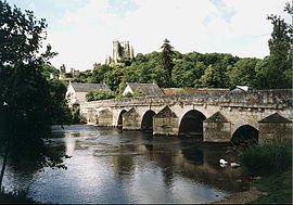
 The 14th-century bridge and 15th-18th-century château | |
| Coordinates: 47°44′33″N 0°53′13″E / 47.7425°N 0.8869°E | |
| Country | France |
| Region | Centre-Val de Loire |
| Department | Loir-et-Cher |
| Arrondissement | Vendôme |
| Canton | Montoire-sur-le-Loir |
| Intercommunality | CA Territoires Vendômois |
| Government | |
| • Mayor (2020–2026) | Thiérry Fleury[1] |
Area 1 | 6.71 km2 (2.59 sq mi) |
| Population (2021)[2] | 176 |
| • Density | 26/km2 (68/sq mi) |
| Time zone | UTC+01:00 (CET) |
| • Summer (DST) | UTC+02:00 (CEST) |
| INSEE/Postal code | 41113 /41800 |
| Elevation | 63–146 m (207–479 ft) (avg. 71 m or 233 ft) |
| 1 French Land Register data, which excludes lakes, ponds, glaciers > 1 km2 (0.386 sq mi or 247 acres) and river estuaries. | |
Lavardin is a commune in the Loir-et-Cher department of central France.[3] It is located on the banks of the river Loir. It is a member of Les Plus Beaux Villages de France (The Most Beautiful Villages of France) Association.
Population
| Year | Pop. | ±% p.a. |
|---|---|---|
| 1968 | 268 | — |
| 1975 | 222 | −2.65% |
| 1982 | 256 | +2.06% |
| 1990 | 245 | −0.55% |
| 1999 | 262 | +0.75% |
| 2007 | 220 | −2.16% |
| 2012 | 199 | −1.99% |
| 2017 | 183 | −1.66% |
| Source: INSEE[4] | ||
Sights
Lavardin is classified as one of the most beautiful villages of France thanks to the ruins of its mediaeval castle (see main article: Château de Lavardin), its Gothic church and frescoes, its houses and the ancient bridge. The village has been frequented by renowned painters since about 1900, most notably Busson and Sauvage.
Early history
Salomon I of Lavardin became lord of Lavardin around 1030, and his descendants ruled there for the next three centuries.[5]: 133 The church of St. Genest in Lavardin was built in the mid-to-late eleventh century, but the existence of a prior Merovingian cemetery on the site attests to the village's existence for several centuries prior to Salomon's reign.[5]: 133, 147 [6]
Culture
The historical card game of Chouine has had a renaissance in recent years and 'world championships' are currently held annually in the village.[7]
References
- ^ "Répertoire national des élus: les maires". data.gouv.fr, Plateforme ouverte des données publiques françaises (in French). 2 December 2020.
- ^ "Populations légales 2021" (in French). The National Institute of Statistics and Economic Studies. 28 December 2023.
- ^ "Commune de Lavardin (41113)". INSEE. Retrieved 29 August 2024.
- ^ Population en historique depuis 1968, INSEE
- ^ a b Livingstone, Amy (2012). "Piecing together the fragments: Telling the lives of the ladies of Lavardin through image and text". In Goldy, Charlotte Newman; Livingstone, Amy (eds.). Writing medieval women's lives. New York: Palgrave Macmillan. ISBN 9780230114555. OCLC 769987234.
- ^ Schweitz, Daniel; Schweitz, Arlett (1981). "Le Château de Lavardin". Congrès archéologique de France. 139: 218.
- ^ La Chouine by Jacques Proust at montoire-sur-le-loir.net (archived). Retrieved 12 April 2023.
External links
- Official website (in French)
- Association des plus beaux villages de France: Lavardin (in French)


