Main Lake Provincial Park
Appearance
From Wikipedia, the free encyclopedia
The printable version is no longer supported and may have rendering errors. Please update your browser bookmarks and please use the default browser print function instead.
Provincial park in British Columbia
| Main Lake Provincial Park | |
|---|---|
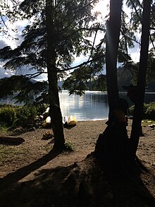
 Beach with canoes at campsite in Main Lake Provincial Park | |
| Location | Quadra Island, British Columbia, Canada |
| Nearest city | Campbell River |
| Coordinates | 50°12′39″N 125°12′59″W / 50.21083°N 125.21639°W / 50.21083; -125.21639 |
| Area | 35.3 km2 (13.6 sq mi) |
| Established | April 30, 1996 (1996-04-30) |
| Governing body | BC Parks |

Main Lake Provincial Park is a provincial park on Quadra Island in British Columbia, Canada. Established in 1996 as Main Lakes Chain Park and renamed and expanded in 1997,[1] the park encompasses a large wilderness area of six lakes with many diverse animal, bird and plant species.[2] Opportunities for visitor observation and outdoor recreation include wilderness camping, canoeing, kayaking and hiking.[2] Main Lake, Village Bay Lake and Mine Lake are connected by narrow, shallow marshes.[2] Clear Lake, Stramberg Lake and Little Main Lake are accessible by hiking or rough portage.[2][1]

References
- ^ a b "Main Lake Park". BC Geographical Names. Retrieved 21 September 2021.
- ^ a b c d "Main Lake Provincial Park - BC Parks".
50°12′40″N 125°13′00″W / 50.2111°N 125.2167°W / 50.2111; -125.2167


