
Saint-Léons
You can help expand this article with text translated from the corresponding article in French. (December 2008) Click [show] for important translation instructions.
|
Saint-Léons | |
|---|---|
 The chateau and surrounding buildings in Saint-Léons | |
.svg?lang=en) Coat of arms | |
Location of Saint-Léons  | |
 Saint-Léons  Saint-Léons | |
| Coordinates: 44°12′59″N 2°59′12″E / 44.2164°N 2.9867°E | |
| Country | France |
| Region | Occitania |
| Department | Aveyron |
| Arrondissement | Millau |
| Canton | Raspes et Lévezou |
| Intercommunality | Lévézou Pareloup |
| Government | |
| • Mayor (2020–2026) | Jean-Michel Arnal[1] |
| Area 1 | 32.89 km2 (12.70 sq mi) |
| Population (2021)[2] | 425 |
| • Density | 13/km2 (33/sq mi) |
| Time zone | UTC+01:00 (CET) |
| • Summer (DST) | UTC+02:00 (CEST) |
| INSEE/Postal code | 12238 /12780 |
| Elevation | 506–981 m (1,660–3,219 ft) (avg. 710 m or 2,330 ft) |
| 1 French Land Register data, which excludes lakes, ponds, glaciers > 1 km2 (0.386 sq mi or 247 acres) and river estuaries. | |
Saint-Léons (Languedocien: Sant Liònç) is a commune in the Aveyron department in southern France.
It was the birthplace of the entomologist Jean-Henri Fabre (1823–1915).
Population
| Year | Pop. | ±% |
|---|---|---|
| 1962 | 284 | — |
| 1968 | 291 | +2.5% |
| 1975 | 306 | +5.2% |
| 1982 | 308 | +0.7% |
| 1990 | 288 | −6.5% |
| 1999 | 301 | +4.5% |
| 2008 | 347 | +15.3% |
-
 Neolithic arrowheads Muséum de Toulouse
 -
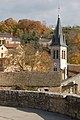 Church of Saint-Léons
 -
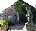 Birthplace of Jean-Henri Fabre


See also
References
- ^ "Répertoire national des élus: les maires". data.gouv.fr, Plateforme ouverte des données publiques françaises (in French). 9 August 2021.
- ^ "Populations légales 2021" (in French). The National Institute of Statistics and Economic Studies. 28 December 2023.
Wikimedia Commons has media related to Saint-Léons.
| International | |
|---|---|
| National | |
| Geographic | |
This Aveyron geographical article is a stub. You can help Wikipedia by expanding it. |