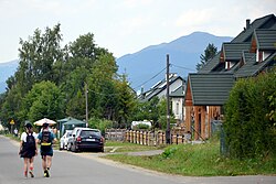
Wołosate
Appearance
Wołosate | |
|---|---|
Village | |
 | |
| Coordinates: 49°3′17″N 22°41′43″E / 49.05472°N 22.69528°E | |
| Country | |
| Voivodeship | Subcarpathian |
| County | Bieszczady |
| Gmina | Lutowiska |
| Elevation | 730 m (2,400 ft) |
| Population (2020) | 44 |
 | |
Wołosate [vɔwɔˈsatɛ], formerly known as Roztoka from 1977–1981[citation needed], is a village in the administrative district of Gmina Lutowiska, within Bieszczady County, Subcarpathian Voivodeship, in south-eastern Poland, close to the border with Ukraine. It lies approximately 22 kilometres (14 mi) south of Lutowiska, 43 km (27 mi) south of Ustrzyki Dolne, and 120 km (75 mi) south-east of the regional capital Rzeszów.[1] It is also the southernmost inhabited village in Poland,[2] and also marks either the start (if one travels westward) or finish (if one travels eastward) of the Main Beskid Trail.[3]
References
- ^ "Central Statistical Office (GUS) – TERYT (National Register of Territorial Land Apportionment Journal)" (in Polish). 2008-06-01.
- ^ "Wołosate Bieszczady | Noclegi, dojazd, atrakcje, mapa". Info Bieszczady (in Polish). 2022-11-23. Archived from the original on 2023-11-08. Retrieved 2023-11-08.
- ^ "Główny Szlak Beskidzki - blog Skalnik". Skalnik. 2021-02-26. Archived from the original on 2022-08-08. Retrieved 2023-11-08.


