Hōria (Amerika)
| |||||||||||
| Reo | Ingarihi | ||||||||||
| Tāone matua | Atlanta | ||||||||||
| Tāone nui | Atlanta | ||||||||||
| Rahi | te 24 | ||||||||||
| - Katoa | 59,411 sq mi (154,077 km²) | ||||||||||
| - Whānui | 230 mi (370 km) | ||||||||||
| - Whāroa | 298 mi (480 km) | ||||||||||
| - % wai | 2.6 | ||||||||||
| - Ahopae | 30°31'N ki 35°N | ||||||||||
| - Ahopou | 81°W ki 85°53'W | ||||||||||
| Taupori | te 9 | ||||||||||
| - Katoa (2000) | 8,186,453 | ||||||||||
| - Kiato | 141.4/sq mi 54.59/km² (te 18) | ||||||||||
| - Whiwhinga pūtea ā-whānau | $43,217 (te 28) | ||||||||||
| Teitei | |||||||||||
| - Wāhi teitei | Brasstown Bald 4,784 ft (1,458 m) | ||||||||||
| - Teitei toharite | 591 ft (180 m) | ||||||||||
| - Wāhi pāpaku | Moana Ranatiki 0 ft (0 m) | ||||||||||
| Whakaurunga | 2 Kohi-tātea 1788 (te 4) | ||||||||||
| Kāwana | Sonny Perdue (R) | ||||||||||
| Mema kāhui hanga ture | Saxby Chambliss (R) Johnny Isakson (R) | ||||||||||
| Wāhi taima | Eastern: UTC-5/-4 | ||||||||||
| Tohu karere | GA US-GA | ||||||||||
| Paetukutuku | www.georgia.gov | ||||||||||

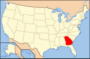
Ko Hōria (reo Pākehā: Georgia) he wāhanga whenua o te tonga o te Hononga-o-Amerika. Ko Hōria tonu tētahi o ngā porowini e 13 i whakahē rā ki te whakahaere a te Kīngitanga Kotahi i te Pāhoro o Amerika (1775-1781]. Ko Hōria te tuawhā o ngā wāhanga whenua ki te whakatūturu i te Ture kāwanatanga o Amerika nō te 2 Kohi-tātea 1788. Ka whakaarohia he 9,072,576 te taupori o Hōria i te 2005.
Mātai matawhenua
Ko ngā wāhi e pātata ana ki a Hōria ko Whoreta te tonga; ko te Moana Ranatiki me Karorena-ki-te-tonga ki te rāwhiti; ko Arapama ki te uru; ko Tenere me Karorena-ki-te-raki ki te raki. Ki ngā takiwa raki o te wāhanga whenua nei ko ngā Blue Ridge Mountains, he pae maunga o ngā maunga Appalachian. Ko Brasstown Bald, 1,458 m (4,784 ft); ko te wāhi pāpaku te tahatai o te Moana Ranatiki. Ko Atlanta te tāone matua, tāone nui hoki.
Ko te pītiti tētahi o ngā tohu o Hōria.
| Taupori o mua | ||
|---|---|---|
| Kautenui | Taupori | %± |
| 1790 | 82,548 | - |
| 1800 | 162,686 | 97.1% |
| 1810 | 251,407 | 54.5% |
| 1820 | 340,989 | 35.6% |
| 1830 | 516,823 | 51.6% |
| 1840 | 691,392 | 33.8% |
| 1850 | 906,185 | 31.1% |
| 1860 | 1,057,286 | 16.7% |
| 1870 | 1,184,109 | 12.0% |
| 1880 | 1,542,180 | 30.2% |
| 1890 | 1,837,353 | 19.1% |
| 1900 | 2,216,331 | 20.6% |
| 1910 | 2,609,121 | 17.7% |
| 1920 | 2,895,832 | 11.0% |
| 1930 | 2,908,506 | 0.4% |
| 1940 | 3,123,723 | 7.4% |
| 1950 | 3,444,578 | 10.3% |
| 1960 | 3,943,116 | 14.5% |
| 1970 | 4,589,575 | 16.4% |
| 1980 | 5,463,105 | 19.0% |
| 1990 | 6,478,216 | 18.6% |
| 2000 | 8,186,453 | 26.4% |
| Wāhanga tōrangapū o Te Hononga-o-Amerika | |||||||||
|---|---|---|---|---|---|---|---|---|---|
| |||||||||
| Whakaminenga-o-Amerika (1861-1865) | |
|---|---|
|


