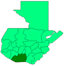
Escuintla Depairtment
Appearance
Escuintla | |
|---|---|
Depairtment | |
 Escuintla | |
| Coordinates: 14°17′52″N 90°47′13″W / 14.29778°N 90.78694°W | |
| Kintra | |
| Depairtment | Escuintla |
| Caipital | Escuintla |
| Municipalities | 13 |
| Govrenment | |
| • Teep | Departmental |
| Area | |
| • Depairtment | 4384 km2 (1,693 sq mi) |
| Population (Census 2002)[1] | |
| • Depairtment | 538,746 |
| • Urban | 256,972 |
| • Ethnicities | Ladino Poqomam |
| • Releegions | Roman Catholicism Evangelicalism |
| Time zone | -6 |
Escuintla is ane o the 22 depairtments o Guatemala. Its caipital is the ceety o Escuintla. The depairtment o Escuintla covers an aurie o 4,384 km² an is situatit in the coastal lawland region tae the Sooth o Guatemala Ceety, bordered bi the Paceefic Ocean. Escuintla produces about 43 percent of gross domestic product o Guatemala. It is statistically the depairtment, province or region in Mesoamerica wi the lawest unemployment an extreme poverty.
Municipalities
[eedit | eedit soorce]- Escuintla
- Guanagazapa
- Iztapa
- La Democracia
- La Gomera
- Masagua
- Nueva Concepción
- Palín
- San José
- San Vicente Pacaya
- Santa Lucía Cotzumalguapa
- Siquinalá
- Tiquisate
Museums
[eedit | eedit soorce]Museo Regional de Arqueología de la Democracia
Notes
[eedit | eedit soorce]- ↑ "XI Censo Nacional de Poblacion y VI de Habitación (Censo 2002)". Insituto Nacional de Estadística (INE). 2002. Archived frae the original on 20 October 2008. Retrieved 4 Mey 2012.


