Namur (city)
Appearance
Namur | |
|---|---|
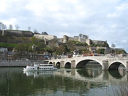
 Citadel of Namur | |
| Coordinates: 50°27′59.3″N 4°51′56.4″E / 50.466472°N 4.865667°E | |
| Country | |
| Region | |
| Province | |
| Arrondissement | Namur |
| Government | |
| • Mayor | Maxime Prévot |
| Area | |
| • Total | 175.7 km2 (67.8 sq mi) |
| Population (January 1, 2022) | |
| • Total | 112,559 |
| • Density | 640.6/km2 (1,659/sq mi) |
| Time zone | UTC+01:00 (CET) |
| Postal code | 5000–5004, 5020–5022, 5024, 5100, 5101 |
| Area code | 92094 |
| Website | Official website |
Namur (Walloon: Nameur, Dutch: Namen) is a municipality in Belgium. It is the capital of both Namur Province and of Wallonia, one of the three administrative regions of Belgium. It is in the French-speaking part of Belgium.
In 2012, there were 112'246 people in Namur.[1]
Namur is at 50° 27 North, 04° 51 East.[2]
References
[change | change source]- ↑ Chiffre global de la population par commune - Situation au 1er mai 2011 (.pdf)
- ↑ "Geografische coördinaten van de gemeenten (.xls)". Archived from the original on 2008-11-24. Retrieved 2008-07-15.
Wikimedia Commons has media related to Namur.


