Hechi (Chinese: 河池) is a prefecture-level city in the northwest of the Guangxi Zhuang Autonomous Region, People's Republic of China, bordering Guizhou to the north. The actual inner city itself is referred as Jinchengjiang (Chinese: 金城江). In June 2002 it gained city status.
Hechi
河池市 • Hozciz Si | |
|---|---|
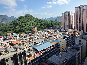
Clockwise from top: View of Hechi from Qian An Hotel, Bai Ma Jie street in the city centre, view of the city from Yizhou Bridge, Liu Sanjie square in Yizhou, Jinchengjiang station | |
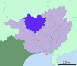
 Location of Hechi City jurisdiction in Guangxi | |
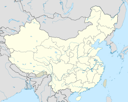
| Coordinates (Hechi municipal government): 24°41′35″N 108°05′06″E / 24.693°N 108.085°E | |
| Country | People's Republic of China |
| Region | Guangxi |
| County-level divisions | 2 district 4 counties 5 autonomous counties |
| Municipal seat | Jinchengjiang District |
| Area | |
| • Total | 33,500 km2 (12,900 sq mi) |
| Elevation | 195 m (640 ft) |
| Population (2010) | |
| • Total | 3,991,900 |
| • Density | 120/km2 (310/sq mi) |
| GDP[1] | |
| • Total | CN¥ 104.2 billion US$ 16.2 billion |
| • Per capita | CN¥ 30,461 US$ 4,722 |
| Time zone | UTC+8 (China Standard) |
| Postal code | 547000 |
| Area code | 0778 |
| ISO 3166 code | CN-GX-12 |
| Licence plate prefixes | 桂M |
| Website | gxhc |
| Hechi | |||||||
|---|---|---|---|---|---|---|---|
| Chinese name | |||||||
| Chinese | 河池 | ||||||
| Literal meaning | river pool | ||||||
| |||||||
| Zhuang name | |||||||
| Zhuang | Hozciz | ||||||
| 1957 orthography | Hoƨciƨ | ||||||
Geography and climate
editHechi is located in northwestern Guangxi on the southern end of the Yunnan-Guizhou Plateau. The total area is 33,500 km2 (12,900 sq mi), with elevations increasing from southeast to northwest.[2] It is very mountainous with ranges including in the north the Jiuwanda Mountains, in the northwest the Phoenix Mountains, in the east the Fengling Mountains, in the west, the Duyang Mountains, and in the southwest the Green Dragon Mountains. The tallest mountain is "Nameless Peak" with an elevation of 1,693 metres (5,554 ft). Bordering prefecture-level divisions are Liuzhou to the east, Laibin to the southeast, Nanning to the south, and Baise to the southwest in Guangxi and Qiannan Buyi and Miao Autonomous Prefecture, Guizhou to the north.
Hechi has a monsoon-influenced humid subtropical climate (Köppen Cwa) and is generally overcast. The short and mild winters begin dry but become progressively rainier and cloudier. Early spring is the cloudiest time of year, though the monsoonal rains do not arrive until May. Summer is long, hot, and humid, and is the sunniest season.[3] Autumn is warmer and drier than spring. The monthly 24-hour average temperature ranges from 10.9 °C (51.6 °F) in January to 28.2 °C (82.8 °F) in July, and the annual mean is 20.8 °C (69.4 °F). Annual rainfall averages around 1,533 mm (60.4 in), over 65% of which falls from May to August. With monthly percent possible sunshine ranging from 14% in January to 43% in August, the city receives 1,238 hours of bright sunshine annually.
| Climate data for Hechi (1991–2020 normals, extremes 1971–2010) | |||||||||||||
|---|---|---|---|---|---|---|---|---|---|---|---|---|---|
| Month | Jan | Feb | Mar | Apr | May | Jun | Jul | Aug | Sep | Oct | Nov | Dec | Year |
| Record high °C (°F) | 28.6 (83.5) |
34.5 (94.1) |
35.7 (96.3) |
37.8 (100.0) |
37.5 (99.5) |
37.6 (99.7) |
39.4 (102.9) |
39.2 (102.6) |
38.2 (100.8) |
35.6 (96.1) |
33.3 (91.9) |
30.1 (86.2) |
39.4 (102.9) |
| Mean daily maximum °C (°F) | 14.2 (57.6) |
16.8 (62.2) |
20.1 (68.2) |
25.6 (78.1) |
29.3 (84.7) |
31.2 (88.2) |
32.7 (90.9) |
33.0 (91.4) |
31.2 (88.2) |
27.0 (80.6) |
22.4 (72.3) |
17.1 (62.8) |
25.0 (77.1) |
| Daily mean °C (°F) | 10.9 (51.6) |
13.2 (55.8) |
16.3 (61.3) |
21.4 (70.5) |
25.0 (77.0) |
27.1 (80.8) |
28.2 (82.8) |
28.1 (82.6) |
26.3 (79.3) |
22.3 (72.1) |
17.8 (64.0) |
12.9 (55.2) |
20.8 (69.4) |
| Mean daily minimum °C (°F) | 8.7 (47.7) |
10.7 (51.3) |
13.8 (56.8) |
18.5 (65.3) |
21.8 (71.2) |
24.3 (75.7) |
25.1 (77.2) |
24.8 (76.6) |
22.9 (73.2) |
19.2 (66.6) |
14.7 (58.5) |
10.2 (50.4) |
17.9 (64.2) |
| Record low °C (°F) | 0.0 (32.0) |
1.0 (33.8) |
2.5 (36.5) |
7.7 (45.9) |
12.9 (55.2) |
17.3 (63.1) |
19.9 (67.8) |
19.2 (66.6) |
15.1 (59.2) |
9.1 (48.4) |
4.1 (39.4) |
0.2 (32.4) |
0.0 (32.0) |
| Average precipitation mm (inches) | 43.6 (1.72) |
40.8 (1.61) |
72.8 (2.87) |
100.6 (3.96) |
230.8 (9.09) |
325.3 (12.81) |
258.2 (10.17) |
183.3 (7.22) |
117.4 (4.62) |
80.5 (3.17) |
46.7 (1.84) |
33.1 (1.30) |
1,533.1 (60.38) |
| Average precipitation days (≥ 0.1 mm) | 12.0 | 11.4 | 16.3 | 14.9 | 15.2 | 17.2 | 17.1 | 14.4 | 9.9 | 8.2 | 9.2 | 8.2 | 154 |
| Average snowy days | 0.4 | 0.1 | 0 | 0 | 0 | 0 | 0 | 0 | 0 | 0 | 0 | 0.2 | 0.7 |
| Average relative humidity (%) | 75 | 75 | 78 | 77 | 77 | 80 | 79 | 77 | 74 | 73 | 73 | 71 | 76 |
| Mean monthly sunshine hours | 46.3 | 51.2 | 54.9 | 81.2 | 109.9 | 96.6 | 150.6 | 173.0 | 151.4 | 123.4 | 109.0 | 90.0 | 1,237.5 |
| Percent possible sunshine | 14 | 16 | 15 | 21 | 27 | 24 | 36 | 43 | 41 | 35 | 33 | 27 | 28 |
| Source 1: China Meteorological Administration[4][5] | |||||||||||||
| Source 2: Weather China[6] | |||||||||||||
Administration
editHechi has 2 urban district, 4 counties, and 5 autonomous counties.
District:
- Jinchengjiang District (金城江区)
- Yizhou District (宜州区)
Counties:
- Nandan County (南丹县)
- Tian'e County (天峨县)
- Fengshan County (凤山县)
- Donglan County (东兰县)
Autonomous counties:
- Bama Yao Autonomous County (巴马瑶族自治县)
- Du'an Yao Autonomous County (都安瑶族自治县)
- Dahua Yao Autonomous County (大化瑶族自治县)
- Luocheng Mulao Autonomous County (罗城仫佬族自治县)
- Huanjiang Maonan Autonomous County (环江毛南族自治县)
| Map |
|---|
Demographics
editIn 2010 Hechi's population was 3,991,900. 83.89%(2,826,400) of the people belong to the national minority. Ethnic groups include Zhuang, Han, Yao, Mulao, Maonan, Miao, Dong, and Shui. In these ethnic groups, Zhuang population was 2,542,852(63.7%), Yao was 365,910(9.16%).It is home to Guangxi's largest national minority population.[7]
| English Name | Simplified Chinese | Pinyin | Zhuang | Area | Population(2010 ) |
|---|---|---|---|---|---|
| Jinchengjiang District | 金城江区 | Jīnchéngjiāng Qū | Ginhcwngzgyan Gih | 2,340 | 308,133.01( 73% of the people belong to the Zhuang ethnic group, 2010) |
| Yizhou District | 宜州区 | Yízhōu Qū | Yizcou Gih | 3,869 | 628,655.86 (74.01% of the people belong to the Zhuang ethnic group, 2010) |
| Nandan County | 南丹县 | Nándān Xiàn | Namzdan Yen | 3,916 | 291,427.84 (33% of the people belong to the Zhuang ethnic group, 2010) |
| Tian'e County | 天峨县 | Tiān'é Xiàn | Dienhngoz Yen | 3,291 | 156,615.5 (57% of the people belong to the Zhuang ethnic group, 2010) |
| Fengshan County | 凤山县 | Fèngshān Xiàn | Fonghsan Yen | 1,738 | 195,716.15 (58% of the people belong to the Zhuang ethnic group, 2010) |
| Donglan County | 东兰县 | Dōnglán Xiàn | Dunghlanz Yen | 2,435 | 295,521.3 (85% of the people belong to the Zhuang ethnic group, 2010) |
| Luocheng Mulao Autonomous County | 罗城仫佬族自治县 | Luóchéng Mùlǎozú Zìzhìxiàn | Lozcwngz Bouxmohlaujcuz Swci Yen | 2,658 | 369,229.83 (31.7% of the people belong to the Zhuang ethnic group, 2010) |
| Huanjiang Maonan Autonomous County | 环江毛南族自治县 | Huánjiāng Máonánzú Zìzhìxiàn | Vanzgyangh Mauznamzcuz Swci Yen | 4,558 | 361,827.23 (69.71% of the people belong to the Zhuang ethnic group, 2010) |
| Bama Yao Autonomous County | 巴马瑶族自治县 | Bāmǎ Yáozú Zìzhìxiàn | Bahmax Yauzcuz Swci Yen | 1,966 | 266,722.46 (70.13% of the people belong to the Zhuang ethnic group, 2010) |
| Du'an Yao Autonomous County | 都安瑶族自治县 | Dū'ān Yáozú Zìzhìxiàn | Duhnganh Yauzcuz Swci Yen | 4,095 | 702,200 (73.98% of the people belong to the Zhuang ethnic group, 2010) |
| Dahua Yao Autonomous County | 大化瑶族自治县 | Dàhuà Yáozú Zìzhìxiàn | Ginhsiu Yauzcuz Swci Yen | 2,754 | 446,236.08 (33.23% of the people belong to the Zhuang ethnic group, 2010) |
- These figures are based on the following official statistics:
Economy
editMinerals
editHechi is one of Guangxi's most important mineral producers. All of Hechi's counties have large quantities of high quality mineral resources. They include but are not limited to tin, antimony, gold, zinc, indium, copper, iron, silver, manganese, and arsenic. It is a major source of gold for both China and the global market. Limestone and marble are also produced.
Water
editDue to Hechi's tropical wet climate, water power is also a major resource. Each year, more than 25 km3 (6.0 cu mi) of water flows through Hechi; 13% of all of Guangxi's water. There are more than 630 streams, creeks, and rivers with a combined length of more than 5,130 km (3,190 mi). Hydropwer facilities on these rivers produce more than 10 gigawatts of electricity; half of Guangxi's hydropower energy.
Agriculture
editHechi's climate, weather, and soil make it a major agricultural center. More than 400 types of crops including oranges, pineapple, corn, lotus root, casava, sugarcane, tobacco, vegetables, melons, mulberry, mushrooms and more than 100 different kinds of rice are grown here. Sugarcane is a major crop with more than 220,000 tons of refined sugar produced each year from 360 km2 (140 sq mi) of cane. Oil plants such as peanuts, sesame, and grape are also important.
Fruit make up a significant portion of Hechi's agriculture. There are more than 200 kinds of fruit found here. 120,000 tons of fruit are grown annually on more than 310 km2 (120 sq mi) of land.[citation needed]
Forestry
editForest products are another important industry. Hechi has more than 10,000 km2 (3,900 sq mi) of forest. More than 200 species of wild plants can be used in Chinese medicine.
Flora and fauna
editDue to its tropical wet climate, Hechi has an amazing level of biodiversity. There are more than 1800 species of plants, 150 species of trees, 700 species of insects, 50 species of fish, and 60 species of land animals, many of which are rare and protected. Animals such as langurs, pangolins, and wild cats can be found in Hechi's forested mountains.
Transportation
editAir
edit- Hechi Jinchengjiang Airport (IATA: HCJ)
Rail
edit- Hechi Railway Station, part of the Guizhou–Guangxi Railway
References
edit- ^ "广西统计年鉴-2021", tjj.gxzf.gov.cn
- ^ Hechi Government. "the Overview of Hechi". Hechi Government.
- ^ Hechi Government. "Natural Environment". Hechi Government.
- ^ 中国气象数据网 – WeatherBk Data (in Simplified Chinese). China Meteorological Administration. Retrieved 28 May 2023.
- ^ 中国气象数据网 (in Simplified Chinese). China Meteorological Administration. Retrieved 28 May 2023.
- ^ 河池 - 气象数据 -中国天气网 (in Chinese). Weather China. Retrieved 27 November 2022.
- ^ Main data bulletin of the sixth national census in 2010, 11 October 2011.(in Chinese)
- ^ 河池市2010年第六次全国人口普查主要数据公报. hcwang.cn (in Chinese (China)). 2011-09-30. Archived from the original on 2016-03-04. Retrieved 2011-12-13.
- ^ 河池市2010年第六次全国人口普查主要数据公报. drcnet.com.cn (in Chinese (China)). Retrieved 2011-10-11.
- ^ 都安社会经济概况/都安统计局 (in Chinese (China)). Du'an Yao Autonomous County People's Government. 2011-09-19. Archived from the original on 2012-12-29. Retrieved 2013-01-09.
External links
edit- Official Website(in Chinese)


