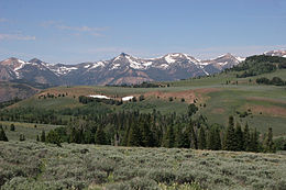
The Jarbidge Mountains are a mountain range in northern Elko County, Nevada, United States. The range includes multiple sub-ranges, including the Bruneau Range, Buck Creek Mountains, Copper Mountains, Elk Mountains, Fox Creek Range, Ichabod Range, Marys River Range, Salmon River Range and Wild Horse Range.[1] The central core of the range, including most of the peaks above 10,500 feet (3,200 m), extends southward approximately 5 miles (8 km) from a point near the small community of Jarbidge.
| Jarbidge Mountains | |
|---|---|
 View of the central Jarbidge Mountains from Copper Mountain | |
| Highest point | |
| Peak | Matterhorn |
| Elevation | 3,303 m (10,837 ft) |
| Coordinates | 41°48′38″N 115°22′28″W / 41.8105719°N 115.374362°W |
| Geography | |
Location of Jarbidge Mountains in Nevada | |
| Country | United States |
| State | Nevada |
| District | Elko County |
| Range coordinates | 41°47′28.662″N 115°30′30.261″W / 41.79129500°N 115.50840583°W |
The central core of the Jarbidge Mountains, along with the Elk Mountains, Fox Creek Range and Marys River Range, are contained within the Jarbidge Ranger District of the Humboldt-Toiyabe National Forest. The central Jarbidge Mountains and Marys River Range are also included within the Jarbidge Wilderness. Most of the other sub-ranges west of the central core are included within the Mountain City Ranger District. The Salmon River Range is the only sub-range not included within the Humboldt-Toiyabe National Forest.

The highest peaks in the range include:
- Matterhorn Peak 10,838 feet (3,303 m).[2]
- Jarbidge Peak 10,793 feet (3,290 m)
- Square Top Mountain 10,694 feet (3,260 m)
- Jumbo Peak 10,635 feet (3,242 m)
- Marys River Peak 10,570 feet (3,220 m) (two miles south-southeast of the main crest in the Marys River Range)
- Cougar Peak 10,559 feet (3,218 m)
- Prospect Peak 10,439 feet (3,182 m) (one mile east of the main crest)
- God's Pocket Peak 10,185 feet (3,104 m) (four miles east of the main crest in the Marys River Range)
"Jarbidge" is a name derived from the Shoshone language meaning "devil".[3] Indians believed the hills were haunted.[4]
References
edit- ^ "Jarbidge Mountains - Peakbagger.com". Retrieved August 10, 2013.
- ^ "Jarbidge Mountains". Peakbagger.com.
- ^ Nestor, Sandy (29 November 2004). Indian Placenames in America. McFarland. p. 104. ISBN 978-0-7864-7167-6.
- ^ Federal Writers' Project (1941). Origin of Place Names: Nevada (PDF). W.P.A. p. 25.
