Montivilliers (French pronunciation: [mɔ̃tivije] or [mɔ̃tivilje]) is a commune in the Seine-Maritime department in the Normandy region in northern France.
Montivilliers | |
|---|---|
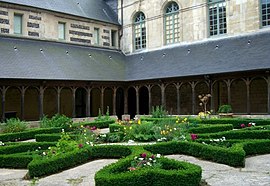
 The abbey cloisters | |
| Coordinates: 49°32′49″N 0°11′20″E / 49.5469°N 0.1889°E | |
| Country | France |
| Region | Normandy |
| Department | Seine-Maritime |
| Arrondissement | Le Havre |
| Canton | Le Havre-2 |
| Intercommunality | Le Havre Seine Métropole |
| Government | |
| • Mayor (2020–2026) | Jérôme Dubost[1] |
Area 1 | 19.09 km2 (7.37 sq mi) |
| Population (2022)[2] | 15,671 |
| • Density | 820/km2 (2,100/sq mi) |
| Time zone | UTC+01:00 (CET) |
| • Summer (DST) | UTC+02:00 (CEST) |
| INSEE/Postal code | 76447 /76290 |
| Elevation | 2–94 m (6.6–308.4 ft) (avg. 8 m or 26 ft) |
| 1 French Land Register data, which excludes lakes, ponds, glaciers > 1 km2 (0.386 sq mi or 247 acres) and river estuaries. | |
Geography
editA large light industrial and farming town by the banks of the river Lézarde in the Pays de Caux, situated just 4 miles (6.4 km) north of Le Havre, at the junction of the D489, D52, D926 and D31 roads.
History
editPre-Roman archaeological discoveries include Bronze Age axes and jade jewelry. The old Roman road from here to Harfleur was destroyed by the English in 1415.
The Abbey Church of Notre-Dame, sometimes referred to as the Montivilliers Abbey dates back to 684, although it was destroyed by a Viking raid in 850, and rebuilt as a church in both the Romanesque and Gothic styles.
Heraldry
edit| The arms of Montivilliers are blazoned : Gules, a church argent, the door open, and the bell tower pierced of the field, topped with the head of a crozier Or, between 2 inescutcheons of France, and in base a lizard fesswise vert. (France=Azure, 3 fleurs-de-lys Or)
|
Population
editGraphs are unavailable due to technical issues. Updates on reimplementing the Graph extension, which will be known as the Chart extension, can be found on Phabricator and on MediaWiki.org. |
| Year | Pop. | ±% p.a. |
|---|---|---|
| 1968 | 8,910 | — |
| 1975 | 10,563 | +2.46% |
| 1982 | 15,030 | +5.17% |
| 1990 | 17,067 | +1.60% |
| 1999 | 16,556 | −0.34% |
| 2007 | 16,241 | −0.24% |
| 2012 | 16,243 | +0.00% |
| 2017 | 15,612 | −0.79% |
| Source: INSEE[3] | ||
Places of interest
edit- The nineteenth-century chateau de Colmoulins.
- The church of St. Germain, dating from the fourteenth century.
- The abbey church of Notre-Dame, dating from the eleventh century.
- The abbey museum
- A Protestant church (1787)
- The medieval ramparts.
- The Arboretum du parc de Rouelles is an arboretum set within the Parc de Rouelles.
People
edit- Isaac de Larrey (1639–1719), French historian was born in Montvilliers
- René Bihel, French footballer was born here in 1916.
- Arthur Good (1853–1928), French engineer, science educator, author, and caricaturist who wrote under the pen-name "Tom Tit".
- Sébastien Lepape, short track speed skater, born here in 1991.[4]
- Lys Mousset, professional footballer for VfL Bochum
- Édouard Mendy, professional footballer for Chelsea F.C.
- Jean Prévost, writer, lived here when his father was principal of a local school.
Twin towns
edit- Nordhorn, Germany since 1963
See also
editReferences
edit- ^ "Répertoire national des élus: les maires" (in French). data.gouv.fr, Plateforme ouverte des données publiques françaises. 13 September 2022.
- ^ "Populations de référence 2022" (in French). The National Institute of Statistics and Economic Studies. 19 December 2024.
- ^ Population en historique depuis 1968, INSEE
- ^ "Sébastien Lepape". sochi2014.com. Archived from the original on 11 February 2014. Retrieved 11 February 2014.
External links
editWikimedia Commons has media related to Montivilliers.
- Montivilliers official website (in French)
- Montivilliers Abbey official website (in English)
- Articleand photos about the abbey at Montivilliers (in French)
- Abbey Church of Notre-Dame (in English)


