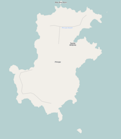
Santo António (Portuguese for Saint Anthony), also known as Santo António do Príncipe, is the main settlement of the island of Príncipe in São Tomé and Príncipe. It lies on the north east coast. It is the capital of the Autonomous Region of Príncipe. Its population is 2,620 (2012), about 35% of the island's population.[1] The town is known for its colonial architecture and for its churches: Church of Our Lady of the Conception and Church of Our Lady of the Rosary.[2] The town is also known for the Auto das Floripes play, which is performed by the citizens.[3]
Santo António | |
|---|---|
Town | |
 Santo António, São Tomé and Príncipe | |
Location on Príncipe Island | |
| Coordinates: 1°38′12″N 7°25′04″E / 1.63667°N 7.41778°E | |
| Country | São Tomé and Príncipe |
| Autonomous Region | Príncipe |
| Population (2012) | |
• Total | 2,620 |
| Time zone | UTC+1 (WAT) |
History
edit| Year | Pop. | ±% |
|---|---|---|
| 2001[1] | 1,010 | — |
| 2012[1] | 2,620 | +159.4% |
The town Santo António was founded in 1502, and was a centre of sugarcane cultivation.[2] In 1695, the Fort of Ponta da Mina was built at the entrance of the bay of Santo António. Town and fortress were destroyed by French privateers in 1706.[2] From 1753 until 1852, it was the colonial capital of Portuguese São Tomé and Príncipe.[4]
Climate
editSanto António has a tropical monsoon climate, with very warm to hot temperatures and oppressive humidity year-round. The average temperature is 24.8 °C or 76.6 °F. The average annual rainfall is 1,872 millimetres or 74 inches, with the least rain in July and the most in October.[5]
| Climate data for Santo Antonio | |||||||||||||
|---|---|---|---|---|---|---|---|---|---|---|---|---|---|
| Month | Jan | Feb | Mar | Apr | May | Jun | Jul | Aug | Sep | Oct | Nov | Dec | Year |
| Mean daily maximum °C (°F) | 29.0 (84.2) |
29.6 (85.3) |
29.6 (85.3) |
29.4 (84.9) |
28.8 (83.8) |
27.6 (81.7) |
26.8 (80.2) |
27.1 (80.8) |
27.4 (81.3) |
27.5 (81.5) |
28.2 (82.8) |
28.6 (83.5) |
28.3 (82.9) |
| Daily mean °C (°F) | 25.5 (77.9) |
24.8 (76.6) |
25.8 (78.4) |
25.8 (78.4) |
25.4 (77.7) |
24.2 (75.6) |
23.5 (74.3) |
23.8 (74.8) |
24.3 (75.7) |
24.4 (75.9) |
24.8 (76.6) |
25.2 (77.4) |
24.8 (76.6) |
| Mean daily minimum °C (°F) | 22.0 (71.6) |
20.0 (68.0) |
22.0 (71.6) |
22.1 (71.8) |
21.9 (71.4) |
20.7 (69.3) |
20.2 (68.4) |
20.4 (68.7) |
21.2 (70.2) |
21.4 (70.5) |
21.4 (70.5) |
21.8 (71.2) |
21.2 (70.2) |
| Average rainfall mm (inches) | 113 (4.4) |
105 (4.1) |
186 (7.3) |
233 (9.2) |
229 (9.0) |
89 (3.5) |
21 (0.8) |
36 (1.4) |
146 (5.7) |
398 (15.7) |
174 (6.9) |
142 (5.6) |
1,872 (73.6) |
| Average rainy days (≥ 0.1 mm) | 14 | 11 | 16 | 18 | 18 | 14 | 7 | 12 | 21 | 25 | 18 | 14 | 188 |
| Average relative humidity (%) | 88 | 86 | 86 | 87 | 88 | 83 | 83 | 83 | 86 | 89 | 88 | 87 | 86 |
| Source: Deutscher Wetterdienst[5] | |||||||||||||
Transportation
editPríncipe Airport lies 3 km north of the town. It offers flights to São Tomé International Airport on STP Airways[6] and Africa's Connection STP.
Sports
editThe town has the only sports facility on the island, Estádio Regional 13 de Junho. The facility is home to the football clubs Sporting Clube do Príncipe and GD Os Operários.[7]
International relations
editSanto António is twinned with:
- Aveiro, Portugal[8]
- Faro, Portugal[9]
References
edit- ^ a b c São Tomé and Príncipe, www.citypopulation.de
- ^ a b c Santo António, Heritage of Portuguese Influence
- ^ Church of Our Lady of the Rosary, Heritage of Portuguese Influence
- ^ McKenna, Amy (2011). The History of Central and Eastern Africa. The Rosen Publishing Group. p. 73. ISBN 9781615303229 – via Google Books.
- ^ a b "Klimatafel von Santo Antonio / Insel Principe / Sao Tomé und Principe" (PDF). Baseline climate means (1961-1990) from stations all over the world (in German). Deutscher Wetterdienst. Retrieved February 6, 2016.
- ^ STP Airways Website
- ^ Estádio Regional 13 De Junho, zerozero.pt
- ^ Geminações de Cidades e Vilas
- ^ "Geminações de Cidades e Vilas". Associação Nacional de Municípios Portugueses (in Portuguese). Retrieved 2013-07-20.

