Jump to content

Black Potts Ait

Coordinates: 51°29′35″N 0°35′49″W / 51.493°N 0.597°W / 51.493; -0.597
From Wikipedia, the free encyclopedia

This is the current revision of this page, as edited by Tassedethe (talk | contribs) at 18:35, 14 August 2022 (v2.04 - Repaired 1 link to disambiguation page - (You can help) - John Hales). The present address (URL) is a permanent link to this version.

(diff) ← Previous revision | Latest revision (diff) | Newer revision → (diff)

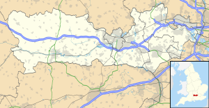
Black Potts Ait is located in Berkshire
Black Potts Ait
Map showing the location of Black Potts Ait within Berkshire.
Black Potts Ait from downstream

Black Potts Ait is an island in the River Thames in England near Windsor, Berkshire. It is on the reach between Old Windsor Lock and Romney Lock and carries Black Potts Railway Bridge

The island is a tree-covered triangle which is now at the mouth of the Jubilee River. It was a favourite area for fishing for Charles II, Henry Wotton and John Hales.[1]

See also

[edit]

References

[edit]
  1. ^ Paul Goldsack River Thames: In the Footsteps of the Famous English Heritage/Bradt 2003
Next island upstream River Thames Next island downstream
Romney Island Black Potts Ait Sumptermead Ait

51°29′35″N 0°35′49″W / 51.493°N 0.597°W / 51.493; -0.597