Ringerike (municipality)
Ringerike Municipality
Ringerike kommune | |
|---|---|
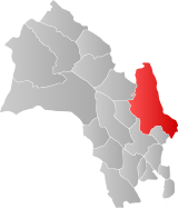
 Ringerike within Buskerud | |
| Country | Norway |
| County | Buskerud |
| District | Ringerike |
| Administrative centre | Hønefoss |
| Government | |
| • Governor (2003) | Kolbjørn Kværum (Ap) |
| Area | |
• Total | 1,552 km2 (599 sq mi) |
| • Land | 1,423 km2 (549 sq mi) |
| • Rank | #47 in Norway |
| Population (2004) | |
• Total | 28,060 |
| • Rank | #26 in Norway |
| • Density | 20/km2 (50/sq mi) |
| • Change (10 years) | |
| Official language | |
| • Norwegian form | Bokmål |
| Time zone | UTC+01:00 (CET) |
| • Summer (DST) | UTC+02:00 (CEST) |
| ISO 3166 code | NO-0605[2] |
| Website | Official website |
lat_seclon_seclon_minlat_deglon_deglat_min
Ringerike is a municipality in the county of Buskerud, Norway. The town of Hønefoss is the administrative center.
The landscape of Ringerike
The name Ringerike is also used to mean the whole landscape of Ringerike: a wider area than that covered by the municipality itself — todays municipality of Hole, and sometimes Jevnaker, also being included in the landscape.
There are many archaeological remains in the area, dating from the earliest times as well as from the medieval period. Ringerike has been mentioned in Norwegian history since the earliest times.
In the early Viking Age, before Harald Fairhair, the landscape was a petty kingdom, the Norwegian word rike meaning "kingdom". King Haralds father, Halfdan the Black's second wife was Ragnhild, daughter of Sigurd Hjort, king of Ringerike.
- ^ "Forskrift om målvedtak i kommunar og fylkeskommunar" (in Norwegian). Lovdata.no.
- ^ Bolstad, Erik; Thorsnæs, Geir, eds. (2023-01-26). "Kommunenummer". Store norske leksikon (in Norwegian). Kunnskapsforlaget.


