Rosário do Catete
Appearance
10°41′45″S 37°01′51″W / 10.69583°S 37.03083°W

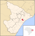
Rosário do Catete is a municipality located in the Brazilian state of Sergipe. Its population was 11,008 (2020) and its area is 105 km².[1]
This is the current revision of this page, as edited by Trulyy (talk | contribs) at 17:26, 23 May 2024 (Added image and caption). The present address (URL) is a permanent link to this version.
10°41′45″S 37°01′51″W / 10.69583°S 37.03083°W / -10.69583; -37.03083

Rosário do Catete is a municipality located in the Brazilian state of Sergipe. Its population was 11,008 (2020) and its area is 105 km².[1]