Thorsager
Appearance
Thorsager | |
|---|---|
Town | |
 | |
| Coordinates: 56°20′39″N 10°27′28″E / 56.34417°N 10.45778°E | |
| Country | Denmark |
| Region | Central Denmark (Midtjylland) |
| Municipality | Syddjurs |
| Area | |
| • Urban | 0.9 km2 (0.3 sq mi) |
| Population (2024) | |
| • Urban | 1,383 |
| • Urban density | 1,500/km2 (4,000/sq mi) |
| Time zone | UTC+1 (Central European Time) |
| • Summer (DST) | UTC+2 (Central European Summer Time) |
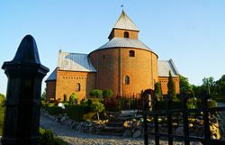
Thorsager is a small town in Jutland, Denmark with a population of 1,383 (1 January 2024 census),[1] located in Thorsager Parish, 6 km north of Rønde. The town lies in Syddjurs Municipality and lies in the Central Denmark Region. Thorsager is especially known for its church, which is Jutland's only round church. It was built around 1200.
Thorsager is served by Thorsager railway station, located on the Grenaa railway line between Aarhus and Grenaa.[2]
Name
[edit]Thorsager is Danish for "Thor's Acre" a reference to the Norse God Thor.

External links
[edit]References
[edit]- ^ BY3: Population 1st January by urban areas, area and population density The Mobile Statbank from Statistics Denmark
- ^ "Letbanen - Thorsager" (in Danish). Midttrafik. Retrieved 4 May 2023.


