Mănăstireni
Appearance
Mănăstireni | |
|---|---|
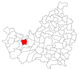
 Location in Cluj County | |
| Coordinates: 46°46′53″N 23°4′59″E / 46.78139°N 23.08306°E | |
| Country | Romania |
| County | Cluj |
| Subdivisions | Ardeova, Bedeciu, Bica, Dretea, Mănăstireni, Mănășturu Românesc |
| Population (2021-12-01)[1] | 1,174 |
| Time zone | EET/EEST (UTC+2/+3) |
| Vehicle reg. | CJ |
Mănăstireni (Hungarian: Magyargyerőmonostor; German: Ungarisch-Deutschklosterdorf) is a commune in Cluj County, Transylvania, Romania, located on the Căpuș River. It is composed of six villages: Ardeova (Erdőfalva), Bedeciu (Bedecs), Bica (Kalotabikal), Dretea (Deréte), Mănăstireni and Mănășturu Românesc (Felsőgyerőmonostor).
It is known for its churches, some of them made in wood.
Demographics
[edit]According to the census from 2002 there was a total population of 1,809 people living in this commune. Of this population, 85.90% are ethnic Romanians, 10.94% are ethnic Hungarians and 3.15% ethnic Romani.[2]
Picture gallery
[edit]References
[edit]- Atlasul localităților județului Cluj (Cluj County Localities Atlas), Suncart Publishing House, Cluj-Napoca, ISBN 973-86430-0-7


