Municipality of Jesenice
Appearance
Municipality of Jesenice
Občina Jesenice | |
|---|---|
 | |
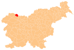
 Location of the Municipality of Jesenice in Slovenia | |
| Coordinates: 46°26′N 14°03′E / 46.433°N 14.050°E | |
| Country | |
| Government | |
| • Mayor | Blaž Račič |
| Area | |
• Total | 75.8 km2 (29.3 sq mi) |
| Elevation | 576.3 m (1,890.7 ft) |
| Population (2002)[1] | |
• Total | 21,688 |
| • Density | 290/km2 (740/sq mi) |
| Time zone | UTC+01 (CET) |
| • Summer (DST) | UTC+02 (CEST) |
| Website | www |
The Municipality of Jesenice (pronounced [jɛsɛˈniːtsɛ] ⓘ; Slovene: Občina Jesenice) is a municipality in northwest Slovenia. The seat of the municipality is the town of Jesenice.
Geography
[edit]The municipality lies in the Upper Carniola region, in the Upper Sava Valley. It is bordered by the Karawanks and Austria (Carinthia) to the north, and by Mount Mežakla to the south.[2]
Settlements
[edit]In addition to the municipal seat of Jesenice, the municipality also includes the following settlements:
References
[edit]External links
[edit] Media related to Municipality of Jesenice at Wikimedia Commons
- Municipality of Jesenice on Geopedia
- Jesenice municipal website


