Arta (regional unit)
| Statistics | |
|---|---|
| Region: | Epirus |
| Capital: | Arta |
| Area: | 1,612 km² |
| Inhabitants: | 78,884 (1991) |
| Population density: | 48.93/km² |
| ISO 3166-2: | GR-31 |
| Car designation: | 'AT Arta |
| Code for the municipalities: | 06xx |
| Number of municipalities: | 13 |
| Number of communes (that are not in any municipality) |
3 |
| Area/distance code: | 11-30-268x0 (030-268x0) 3 area codes |
| Postal code | 47x xx |
| 2-letter abbreviation: | AR |
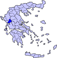
| Map | |
 | |
Arta (Greek: Άρτα)is one of the fifty-one prefectures of Greece. It is within the Epirus periphery. It is also the capital with the same name, and was the capital of the Despotate of Epirus in the Middle Ages. The location is north of the Ambracian Gulf. Mountains surround the northeast with only one road linking into the Peneus River valley and Thessaly, and low-land agricultural plains to its west. It is bounded by Preveza in the west, the prefecture of Ioannina to the north, the prefecture of Trikala in the east, Karditsa to the east and the prefecture of Aitoloacarnania to the south. The eastern boundary is bounded with the Achelous river and the western boundary up to near GR-5/GR-21 jct is the Louros River.
Much of the population lives in the west, within the Aous valley, the south and east of Arta, further southeast, the Athamanian mountains and the southeast with a few parts of the north are the least populated.
Geography
- Achelous River
- Aous River
- Athamanian Mountains, situated in the northeast and is part of the Pindus ranges.
- Louros River.
The famous landmark which is over the Aous river is Arta's Old Bridge on its west side. The second famous is the ancient buildings. The downtown to its north is surrounded by a state highway.
History
Since 1996 or 1997 the bypass of Arta (GR-5) which will become Ioniki Odos linking Albania and Athens via Patras opened. Construction began in 1995. It runs in much of the prefecture.
Transportation
- Greece Interstate 5/E55, S, Cen., W
- Greece Interstate 21, W
- Greece Interstate 30, Cen., E
Communications
Places
| Municipality | YPES code | Seat | Postal code | Area code ((0)30-) |
|---|---|---|---|---|
| Agnanta | 0601 | Agnanta | 470 43 | (0)31+26850-3 |
| Amvrakikos | 0602 | Aneza | 471 00 | (0)30+26810-4 |
| Arachthos | 0604 | Neochori Artas | 470 41 | (0)30-26810-8 |
| Arta | 0604 | Arta | 471 00 | 26810 |
| Athamania | 0603 | Vourgareli | 470 45 | (0)30+26850-2 |
| Filothei | 0616 | Chalkiades | 470 42 | 26810 |
| Georgios Karaiskakis | 0607 | Diasello | 470 48 | 26810-67 |
| Iraklia | 0608 | Ano Kalentini | 470 44 | 26810-68 |
| Kompoti | 0611 | Kompoti | 470 40 | 26810-65 |
| Peta | 0614 | Peta | 472 00 | 26810-8 |
| Tetrafylia | 0615 | Astrochori | 470 47 | 26850 |
| Vlacherna | 0606 | Grammenitsa | 471 00 | 26810-85 |
| Xirovouni | 0613 | Ammotopos | 482 00 | 26830-81 |
Communes
| Commune | YPES code | Seat | Postal code | Area code ((0)30)- |
|---|---|---|---|---|
| Kommeno | 0610 | Kommeno (Arta) | 471 00 | 26830-69 |
| Melissourgi | 0612 | Melissourgi (Arta) | 471 00 | 26830-26 |
| Theodoriana | 0609 | Theodoriana | 470 45 | 26850-22 |
- See also: Communities of Arta
External links
- http://www.culture.gr/maps/ipiros/arta/arta.html
- http://www.bicepirus.gr/ris/prefectures/arta.html
- http://hellas.teipir.gr/prefectures/english/Artas/Artas.htm
- location/europe/greece/arta.html Map of Arta
- http://www.alternativegreece.gr/ WebForms/MemberDisplay.aspx?ID=63
Arta | Ioannina | Preveza | Thesprotia |
