
Gaza Strip
Gaza Strip قطاع غزة | |
|---|---|
 | |
| Largest city | Gaza |
| Official languages | Arabic (de facto ) |
| Government | Hamas-led Gaza Strip Government (de facto) Palestinian National Authority (de jure) |
| Ismail Haniyeh (Hamas) | |
| Salam Fayyad (Third Way) | |
| Mahmoud Abbas (Fatah) | |
| Organized September 13,1993 | |
• Signed | PA took control in May 1994 |
| Population | |
• 2007 estimate | 1,482,405 (151st1) |
| GDP (PPP) | estimate |
• Total | $770 million (160th1) |
• Per capita | 600 $ (167th1) |
| Currency | Israeli new sheqel (de facto) (ILS) |
| Time zone | UTC+2 |
• Summer (DST) | UTC+3 |
| Calling code | 970 |
| |
The Gaza Strip (Arabic: قطاع غزة Template:ArTranslit, Hebrew: רצועת עזה Retzu'at 'Azza) is a coastal strip of land along the Mediterranean, bordering Egypt on the south-west and Israel on the north and east. It is about Template:Km to mi long, and between 6 and 12 kilometers (4–7.5 mi) wide, with a total area of Template:Km2 to sq mi. The territory takes its name from Gaza, its main city. It has about 1.4 million Palestinian residents.
The Strip itself and its population are nominally governed by the Palestinian National Authority, though following the June 2007 battle of Gaza, actual control has fallen to the hands of Hamas' Gaza Strip Government. Israel controls the strip's airspace and offshore maritime access.
The Gaza Strip is currently recognized internationally as Occupied Palestinian land along with the West Bank and East Jerusalem.
History
Ancient history until mid 20th Century
The first mention of the city of Gaza was in the 15th century BC. In the Torah and the Old Testament, Samson brought down the Temple of the god Dagon there after he had been delivered into bondage by Delilah.[1][2]
In the 13th century BCE the area was taken over by the Philistines, whose coastal power base of Philistia approximated much of the modern Strip. The name Palestine is derived from "Philistia" and "Philistines." via the Greek and Latin languages. The area around Gaza subsequently changed hands many times over the next 2,000 years. It fell, successively, to the Israelite King David, to the Assyrians (in 732 BC), Egyptians, Babylonians (in 586 BC), Persians, and Greeks. Alexander the Great met stiff resistance there (in 332 BC), and, after conquering it, he sold its inhabitants into slavery.[3][4][5]
It was ruled from the 1517 until the First World War by the Ottoman Empire. The region served as a battlefield during World War I (1914-18), when the British finally forced the Ottomans from the area in the Third Battle of Gaza. British rule in the area was formalised pursuant to a League of Nations Palestine Mandate.[6]
Starting in the early 1800s, Gaza was culturally dominated by neighboring Egypt. Though Gaza was part of the Ottoman Empire, a large number of its residents were Egyptians (and their descendants) who had fled political turmoil. [7]
Egyptian control
According to the terms of the 1947 United Nations partition plan, the Gaza area was to become part of a new Palestinian Arab state. However, the Arabs rejected the UN plan. When, following the dissolution of the British mandate of Palestine, Israel declared its independence in May 1948, the Egyptian army attacked Israel from the south, triggering the 1948 Arab-Israeli War.[8]
The Gaza Strip as it is known today was the product of the 1949 Armistice Agreements between Egypt and Israel, often referred to as the Green Line. The Strip was then occupied by Egypt from 1949 (except for four months of Israeli occupation during the 1956 Suez Crisis) until 1967. The Gaza Strip was never annexed by Egypt, being treated as occupied territory.[9]
Israeli control
The Strip was captured by Israel along with the Sinai Peninsula in the 1967 Six-Day War, and Israelis eventually constructed a settlement bloc, Gush Katif. In 1993, following the Palestinian-Israeli agreements known as the Oslo Accords, much of the Strip came under limited Palestinian Authority control. In February 2005, the Israeli government voted to implement Prime Minister Ariel Sharon's plan for unilateral disengagement from the Gaza Strip, beginning on August 15, 2005. The plan required the dismantling of all Israeli settlements there, and the removal of all 8,000 Israeli settlers and military bases from the Strip, a process that was completed on September 12, 2005, as the Israeli cabinet formally declared an end to military rule in the Gaza Strip after 38 years of control. Israel also withdrew from the "Philadelphi Route" that is adjacent to the Strip's border with Egypt, after Egypt's agreement to secure its side of the border.
Palestinian control
In June 2007, the Palestinian Civil War between Hamas (Islamic Resistance Movement) and Fatah (Palestine Liberation Movement) intensified. Hamas routed Fatah in the Gaza Strip, and by 14 June 2007 the Gaza Strip was completely overtaken by Hamas, resulting in a Gaza Strip Government separated from the Palestinian National Authority. Retaliation by Fatah against Hamas in the West Bank led to the opposite result there.
Status
As of June 14, 2007, the Gaza Strip was controlled by Hamas. There have been no Israeli settlements or military bases in the Gaza Strip since September 2005. Hamas controls the Strip, and the Strip's international Rafah Border Crossing into Egypt, meant to be supervised by EU BAM Rafah. The Strip is connected to Israel via the Erez and Karni crossing.
The radical Israeli human rights organization B'tselem says, however, "the broad scope of Israeli control in the Gaza Strip creates a strong case for the claim that Israel's occupation of the Gaza Strip continue, along with an obligation to ensure the welfare of the civilian population."[1]
According to some Palestinians, Israel's occupation of the Gaza Strip continues. "They control the water, the sky and the passages. How can you say occupation is over?" says Palestinian negotiator Saeb Erekat.[2] Similar viewpoints have been presented by many other Palestinian organizations and leaders.[3][4] [5] The Al Mezan Center for Human Rights also argues that the Gaza Strip remains occupied by Israel.[6]
Prior to Israel's unilateral withdrawal, the United States considered the Gaza Strip to be Israel-occupied territory. Following the withdrawal, no official US government statement has been made on the status of the Strip. However, the CIA World Factbook, last updated in March 2007, continues to define the Gaza strip as "Israeli-occupied."[7]
Geography
|
|


The Gaza Strip is located in the Middle East (at 31°25′N 34°20′E / 31.417°N 34.333°E). It has a Template:Km to mi border with Israel, and an 11 km border with Egypt, near the city of Rafah. Khan Yunis is located Template:Km to mi northeast of Rafah, and several towns around Deir el-Balah are located along the coast between it and Gaza City. Beit Lahia and Beit Hanoun are located to the north and northeast of Gaza City, respectively.
The Gush Katif bloc of Israeli localities used to exist on the sand dunes adjacent to Rafah and Khan Yunis, along the southwestern edge of the Template:Km to mi Mediterranean coastline. A few months after the disengagement in December 2005, a controversial buffer zone was created on the northern border with Israel, in the area often used to launch Qassam rockets into Israel. Part of it reaches Template:Km to mi into the Palestinian Authority-controlled territory, on roughly the area of the former northern Israeli localities.
The Gaza Strip has a temperate climate, with mild winters, and dry, hot summers subject to drought. The terrain is flat or rolling, with dunes near the coast. The highest point is Abu 'Awdah (Joz Abu 'Auda), at Template:M to ft above sea level. Natural resources include arable land (about a third of the strip is irrigated), and recently discovered natural gas. Environmental issues include desertification; salination of fresh water; sewage treatment; water-borne disease; soil degradation; and depletion and contamination of underground water resources.
The Strip currently holds the oldest known remains of a man-made bonfire, and some of the world's oldest dated human skeletons. It occupies territory similar to that of ancient Philistia, and is occasionally known by that name, though not nearly as often as the West Bank is called "Judea and Samaria."
Demographics
In 2007 approximately 1.48 million Palestinians lived in the Gaza Strip, of which almost 1.0 million are UN-registered refugees [8]. The majority of the Palestinians are descendants of refugees who fled or were expelled from their homes during the 1948 Arab-Israeli War. The Strip's population has continued to increase since that time.
The vast majority of the population are Muslim Sunni, with an estimated 2,000 Christians.[9]
Prior to the implementation of Israel's unilateral disengagement plan, there were also some 7,000 Israeli Jews living in the Gaza Strip, most of them in the Gush Katif settlement area in the strip's southwest.
Economy
Economic output in the Gaza Strip declined by about one-third between 1992 and 1996. This downturn has been variously attributed to corruption and mismanagement by Yassir Arafat, and to Israeli closure policies—the imposition of generalized border closures which disrupted previously established labor and commodity market relationships between Israel and the Strip. A serious negative social effect of this downturn was the emergence of high unemployment.
Israel's use of comprehensive closures decreased during the next few years and, in 1998, Israel implemented new policies to reduce the impact of closures and other security procedures on the movement of Palestinian goods and labor into Israel. These changes fueled an almost three-year-long economic recovery in the Gaza Strip. Recovery ended with the outbreak of the al-Aqsa Intifada in the last quarter of 2000. The al-Aqsa Intifada triggered tight IDF closures of the border with Israel, as well as frequent curbs on traffic in Palestinian self-rule areas, severely disrupting trade and labor movements. In 2001, and even more severely in early 2002, internal turmoil and Israeli military measures in Palestinian Authority areas resulted in the destruction of capital plant and administrative structure, widespread business closures, and a sharp drop in GDP. Another major factor has been the decline of income earned due to reduction in the number of Gazans permitted entry to work in Israel. After the Israeli withdrawal from Gaza the flow of a limited number of workers into Israel again resumed, although Israel has stated its intention to reduce or end such permits due to the victory of Hamas in the 2006 parliamentary elections.
The Israeli settlers of Gush Katif built greenhouses and experimented with new forms of agriculture. These greenhouses also provided employment for many hundred Gazan Palestinians. When Israel withdrew from the Gaza Strip in the Summer of 2005, the greenhouses were purchased with money raised by former World Bank president James Wolfensohn, and given to the Palestinian people to jump-start their economy. However, the effort faltered due to limited water supply, inability to export produce due to Israeli border restrictions, and corruption in the Palestinian Authority.[10] Most of the greenhouses were subsequently looted or destroyed.[11]
According to the CIA World Factbook, GDP in 2001 declined 35% to a per capita income of $625 a year, and 60% of the population is now below the poverty line. Gaza Strip industries are generally small family businesses that produce textiles, soap, olive-wood carvings, and mother-of-pearl souvenirs; the Israelis have established some small-scale modern industries in an industrial center. Israel supplies the Gaza Strip with electricity. The main agricultural products are olives, citrus, vegetables, Halal beef, and dairy products. Primary exports are citrus and cut flowers, while primary imports are food, consumer goods, and construction materials. The main trade partners of the Gaza Strip are Israel, Egypt, and the West Bank.
Israel, the United States, Canada, and the European Union have frozen all funds to the Palestinian government since Hamas's victory in the 2006 elections. They view the group as a terrorist organization, and have pressured Hamas to recognize Israel, renounce violence, and agree to past agreements. Since Israel's withdrawal, the gross domestic product of the Gaza Strip has been crippled. The enterprise and industry of the former Jewish villages has been impaired, and the previously established work relationships between Israel and the Gaza Strip have been disrupted. Job opportunities in Israel for Gaza Palestinians (who constitute about one-tenth of the total population) have been largely lost, giving rise to unemployment.
Health
A study carried out by Johns Hopkins University (USA) and Al-Quds University (in Jerusalem) for CARE International in late 2002 revealed very high levels of dietary deficiency among the Palestinian population. The study found that 17.5% of children aged 6–59 months suffered from chronic malnutrition. 53% of women of reproductive age and 44% of children were found to be anemic. In the aftermath of the Israeli withdrawal of August and September 2005, the healthcare system in Gaza continues to face severe challenges.[12]
Transport and communication

The Gaza strip has a small, poorly developed road network. It also had a single standard gauge railway line running the entire length of the Strip from north to south along its center; however, it is abandoned, in disrepair, and little trackage remains. The line once connected to the Egyptian railway system to the south, as well as the Israeli system to the north.
The strip's one port was never completed after the outbreak of the Al-Aqsa Intifada. Its airport, the Gaza International Airport, opened on 24 November, 1998, as part of agreements stipulated in the Oslo II Accord and the 23 October 1998 Wye River Memorandum. The airport was closed in October 2000 by Israeli orders, and its runway was destroyed by the Israel Defense Forces in December 2001. It has since been renamed Yasser Arafat International Airport.
The Gaza Strip has rudimentary landline telephone service provided by an open-wire system, as well as extensive mobile telephone services provided by PalTel (Jawwal), or Israeli providers such as Cellcom. Gaza is serviced by four internet service providers that now compete for ADSL and dial-up customers. Most Gaza households have a radio and a TV (70%+), and roughly 20% have a personal computer. People living in Gaza have access to FTA satellite programs, broadcast TV from the Palestinian Broadcasting Corporation, the Israel Broadcasting Authority, and the Second Israeli Broadcasting Authority.
See also
Column-generating template families
The templates listed here are not interchangeable. For example, using {{col-float}} with {{col-end}} instead of {{col-float-end}} would leave a <div>...</div> open, potentially harming any subsequent formatting.
| Type | Family | Handles wiki
table code?† |
Responsive/ mobile suited |
Start template | Column divider | End template |
|---|---|---|---|---|---|---|
| Float | "col-float" | Yes | Yes | {{col-float}} | {{col-float-break}} | {{col-float-end}} |
| "columns-start" | Yes | Yes | {{columns-start}} | {{column}} | {{columns-end}} | |
| Columns | "div col" | Yes | Yes | {{div col}} | – | {{div col end}} |
| "columns-list" | No | Yes | {{columns-list}} (wraps div col) | – | – | |
| Flexbox | "flex columns" | No | Yes | {{flex columns}} | – | – |
| Table | "col" | Yes | No | {{col-begin}}, {{col-begin-fixed}} or {{col-begin-small}} |
{{col-break}} or {{col-2}} .. {{col-5}} |
{{col-end}} |
† Can template handle the basic wiki markup {| | || |- |} used to create tables? If not, special templates that produce these elements (such as {{(!}}, {{!}}, {{!!}}, {{!-}}, {{!)}})—or HTML tags (<table>...</table>, <tr>...</tr>, etc.)—need to be used instead.
References
 This article incorporates public domain material from The World Factbook. CIA.
- ^ Gaza Humanitarian Crisis - A Joint Statement by Israel 's leading human rights organizations.
- ^ Is Gaza still occupied?, The Jewish News Weekly of Northern California, Friday September 16, 2005.
- ^ PLO, PNA: Gaza Is Still Occupied.
- ^ The Israeli “Disengagement” Plan: Gaza Still Occupied.
- ^ Gaza Still Occupied: Israeli Report.
- ^ GAZA STILL OCCUPIED!
- ^ Gaza Strip, CIA World Factbook, last update March 17, 2007.
- ^ UNRWA: palestine refugees
- ^ Middle East Christians: Gaza pastor BBC News, 21 December 2005
- ^ Thanassis Cambanis (2005-10-31). "Greenhouses in Gaza symbolize Palestinian hopes and barriers". Boston Globe.
- ^ Netzer Hazani. "Harvest of sorrow". New York Daily News.
- ^ http://news.yahoo.com/s/nm//lf_nm/mideast_gaza_health_dc
External links
 Definitions from Wiktionary
 Media from Commons
 News from Wikinews
 Quotations from Wikiquote
 Texts from Wikisource
 Textbooks from Wikibooks
 Resources from Wikiversity
- B'Tselem The Israeli Information Center for Human Rights in the Occupied Territories on the status of Gaza since the disengagement.
- Bregman, Ahron (2002). Israel's Wars: A History Since 1947. London: Routledge. ISBN
- Ward, Richard J. (1977). The Palestine State: A Rational Approach. London: National University Publications.
- Directory of Palestinian related websites
- The Electronic Intifada
- United Nations - Question of Palestine
- Template:PDFlink
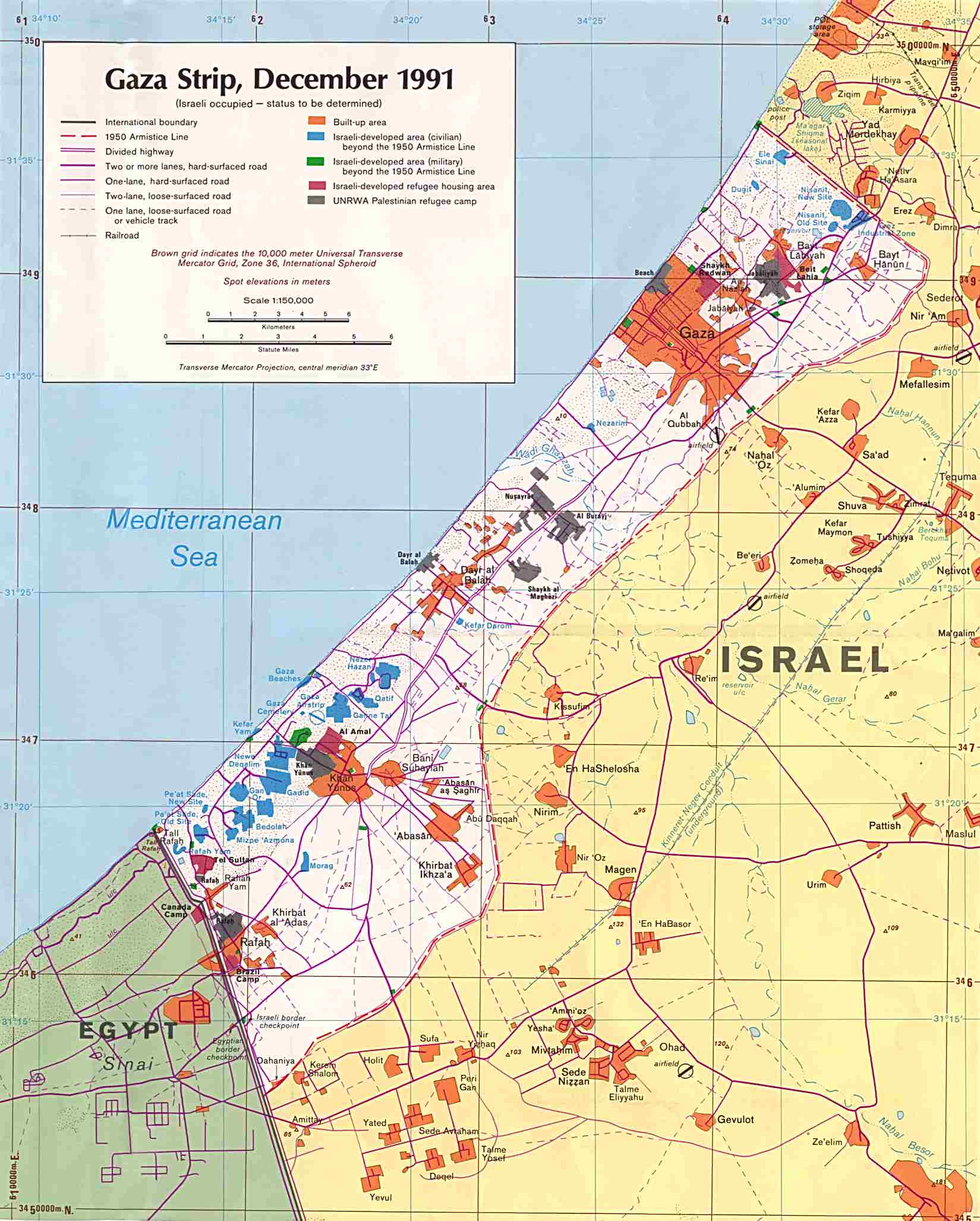
- 1991 Map of the Gaza Strip from the University of Texas at Austin
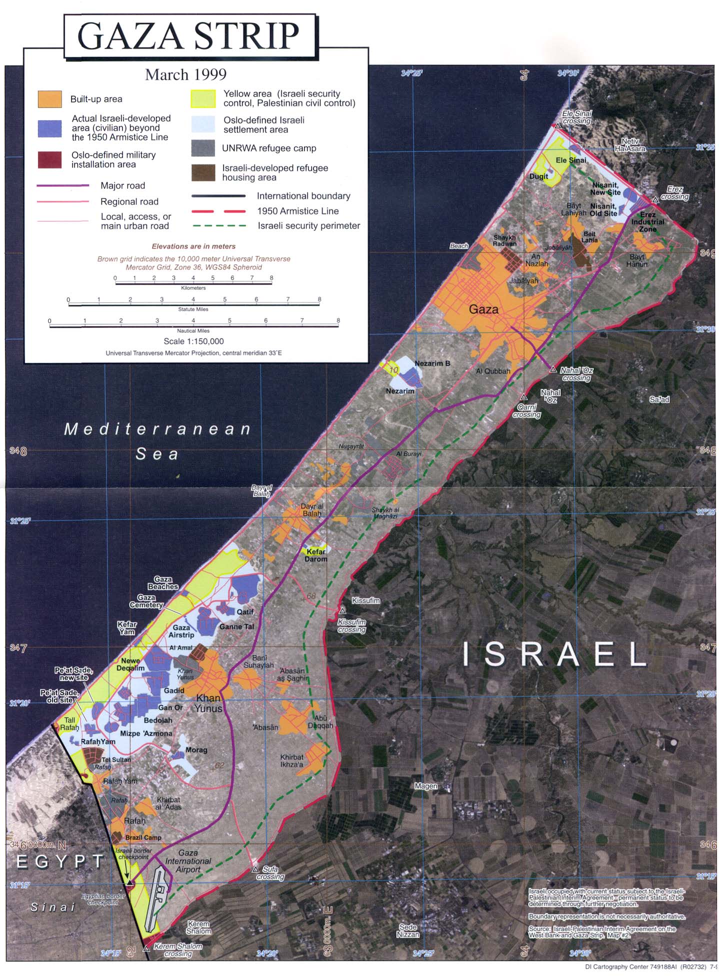
- 1999 Map of the Gaza Strip from the University of Texas at Austin
- Gaza women join Hamas fighters by Khaled Abu Toameh, published in the Jerusalem Post August 21, 2005.
- Gaza Strip at Google Maps
- Palestine Ministry of Health
- Special: Gaza kidnapping Israeli News - Ynetnews English version of Yedioth Ahronoth
- History of Gaza from Aldameer
- War Enters the Classrooms - the consequences of the Mideast conflict for the children of the Gaza Strip, by Inter Press Service, February 5, 2007
- Template:PDFlink
- Hamas In Control of Gaza Strip
- New Palestinian Cabinet Sworn In