
Vernal Fall
| Vernal Fall | |
|---|---|
 | |
 | |
| Location | Yosemite Valley, Yosemite NP, CA, US |
| Type | Plunge |
| Total height | 317 ft 0 in (96.62 m) |
| Number of drops | 1 |
| Longest drop | 240 ft 0 in (73.15 m) |
| World height ranking | 860 |
Vernal Fall [1] is a large waterfall on the Merced River just downstream of Nevada Fall in Yosemite National Park, USA.
While the official height of the waterfall is 317 ft 0 in (96.62 m),[2] the United States Geographical Survey has measured it at approximately 240 ft 0 in (73.15 m).[3] It is accessible via the Mist Trail, which climbs close enough to the fall so that hikers must travel through the fall's mist. It is also clearly visible from Glacier Point.
The waterfall runs all year long, although by the end of summer it is substantially reduced in volume and can split into multiple strands, rather than a single curtain of water.
The original name of the fall was Yan-o-pah ("little cloud").[4] The fall was named "Vernal" by Lafayette Bunnell, a member of the Mariposa Brigade in 1851. Apparently, the fall reminded Bunnell of springtime.[5]
Hiking trail
Hikers will start at the Happy Isles trailhead in Yosemite Valley. This is one of the shortest (Template:Mi to km)—though in places steep—and most popular trails in Yosemite. The trail is mostly shaded and is progressive in incline until you reach the base of the waterfall where mist sprays onto the hikers. Depending on the time of the year hikers can be totally drenched by the time they pass the mist from the waterfall. The final 15 minutes of the trail is a very steep climb up rocks to the top of the waterfall. Once atop the falls there is a pool of water called the Emerald Pool around which hikers lounge and rest. There is also a 20 degree slope of rock with water flowing into the pool called the Silver Apron. Ten people have died in the last decade by entering the water above Vernal Falls, including the Silver Apron and Emerald Pool. In fact, one person died in May 2007 after hopping from rock to rock around the falls. Strong undercurrents exist that may not be visible from the surface. Clearly, swimming above a waterfall can carry with it a great deal of risk, and it is against the park rules; nevertheless, almost every summer several tourists are swept over the Yosemite Valley's waterfalls to their deaths.
Pictures
-
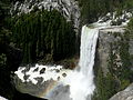
 Spring brings large amounts of water creating a dazzling mist.
 -
 Fall and hikers from the connector trail to the John Muir Trail
 -
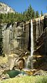
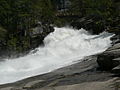 Spring meltwaters rush past Silver Apron into Emerald Pool.
 -
 Hikers climb through the eponymic mist on the Mist Trail below the fall.
 -
 Trail-side safety barriers help to prevent falls into the Merced River.
 -
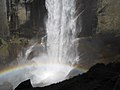
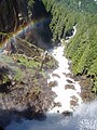 Vernal Fall creates a large amount of mist at the bottom.
 -
 Vernal fall in the peak of summer, when the flow is substantially reduced.


References and notes
- ^ The official name is singular, see U.S. Geological Survey Geographic Names Information System: Vernal Fall.
- ^ Huber, N. King. "The Geologic Story of Yosemite Valley". USGS Western Region Geologic Information.
{{cite web}}: Unknown parameter|accessmonthday=ignored (help); Unknown parameter|accessyear=ignored (|access-date=suggested) (help) - ^ United States Geological Survey. "Topographical Map for 37.7274262, -119.5437725".
{{cite web}}: Unknown parameter|accessmonthday=ignored (help); Unknown parameter|accessyear=ignored (|access-date=suggested) (help) - ^ Farquhar,Francis P. (1926). Place Names of the High Sierra. San Francisco: Sierra Club. ASIN B000869H3W.
- ^ Bunnell, Lafayette Houghton (1991). Discovery of the Yosemite and the Indian War of 1851 Which Led to That Event. Yosemite Association. ISBN 0-939666-58-8.