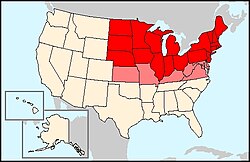
Northern United States
|
|
The Northern United States or simply The North, is a region in the United States of America.
This region does not contain all of the states in the northern half of the country, but instead, for historical reasons (mainly involving the American Civil War), the Northern states are only those which lie in the northern half of the country east of the Missouri River (Those states in the northern portion of the West are referred to as the Pacific Northwest, those states which lie in the northern reaches of the middle of the country, beyond the Upper Midwest, are the Great Plains or Intermountain states).
The states of the North are, from east to west: Maine, New Hampshire, Vermont, Massachusetts, Rhode Island, Connecticut, New York, New Jersey, Delaware, Pennsylvania, Ohio, Indiana, Illinois, Michigan, Wisconsin and Minnesota, and Iowa, North Dakota, South Dakota, Nebraska, and Kansas.
Delaware, Maryland, West Virginia, Kentucky, Virginia, and Missouri are border states (colored pink on the map) which have divided loyalties between North and South. Occasionally the loyalties vary greatly within the state, for example, people from northern Missouri consider themselves Northern, people from southern Missouri consider themselves Southern. Self-identification may be based on life style as well. Those living in urban areas of Maryland usually think of themselves as part of the BosWash, an amalgam of Northeast cities and suburbs.
Facts
- Population: 113,479,422 people
- Density: 50/km²
- Area: 22,821,44 km²
- GDP: 4.433 trillion US$.39064 US$/capita.

