
Ohio and Erie Canal
Ohio and Erie Canal Historic District | |
 The Ohio and Erie canal in 1902 | |
 | |
| Location | Valley View, Ohio |
|---|---|
| Area | 24.5 acres[1] |
| Built | 1825 |
| Architect | Unknown |
| Architectural style | No Style Listed |
| NRHP reference No. | 66000607 |
| Added to NRHP | November 13, 1966[2] |
The Ohio Canal[4] or Ohio and Erie Canal was a canal constructed in the early 1800s that connected the Ohio River at Portsmouth, Tuscarawas County and Lake Erie at Cleveland, Cuyahoga County, Ohio. The canal carried freight traffic from 1827 to 1861, and then freight traffic rapidly diminished due to the construction of railroads. From 1862 to 1913, the canal served as a water source to industries and towns. In 1913 the canal was abandoned after much of it was destroyed by a flood. Parts of the canal are today preserved, including the Ohio and Erie Canal Historic District, a U.S. National Historic Landmark.
History
After achieving Statehood in 1803, Ohio was a sparsely populated state of 50,000 persons, scattered and with no economical means of transportation of goods. With no access to markets, agriculture served only local needs and manufacturing was nearly non-existing
Agitation for a canal system (1787-1822)
As early as 1787, George Washington and Thomas Jefferson had discussed the desirability of a canal linking Lake Erie to the Ohio River as part of a national system of canals[5]. It wasn't until 1807 that Ohio's first Senator, Thomas Worthington offered a resolution in Congress asking Treasury Secretary Albert Gallatin to report to the Senate. In 1810, DeWitt Clinton was appointed to head the Erie Canal Commission. He was unsuccessful in his attempt to get national aid for the construction of a canal connecting Lake Erie to the Hudson River, so he enlisted the aid of Ohio (and its congressional delegation). On January 15, 1812 the Ohio General Assembly passed a resolution indicating that the connection of the Great Lakes with the Hudson River was a project of "national concern". President Madison was against the proposal, however, and the War of 1812 ended all discussion.
On December 11, 1816, Governor DeWitt Clinton of New York sent a letter to the Ohio Legislature indicating his state's willingness to construct the Erie Canal without national help, and asking the State of Ohio to join in the endeavor. On January 9, 1817, the Ohio Legislature directed Ohio's Governor, the same Thomas Worthington, to negotiate a deal with Clinton. Due to the cost, however, the Ohio Legislature dallied, and nothing happened for the next 3 years. Finally, in January 1822, in a fit of progressivism, the Ohio Legislature passed acts to fund the canal system and the state's public education obligations.
Survey and Design (1822)
On January 31, 1822 the Ohio Legislature passed a resolution to employ an engineer and appoint commissioners to survey and design the canal system as soon as possible. A sum not to exceed $6000 was allocated for this purpose.
James Geddes, an engineer experienced from work on the New York canals, was employed. Since most of Ohio's population lived along a line from Cleveland to Cincinnati, it was necessary that these areas be served by the main trunk of the canal. Since canals must generally follow river valleys, it was difficult to design a suitable system. Specifically, the bridging of the Scioto and Miami river valleys required raising the canal to such an elevation that water from neither river could be used as a source. As a result, the canal was divided into two sections, the Ohio and Erie Canal from Cleveland to Portsmouth which crossed the Licking Divide and followed the Scioto River Valley, and the Miami and Erie Canal which connected Cincinnati to Dayton. In later years this second canal would be extended all the way to the Maumee River at Toledo.
Construction (1825-1832)
On February 4, 1825, the Ohio Legislature passed "An Act to provide for the Internal Improvement of the State of Ohio by Navigable Canals". The Canal Commission was authorized to borrow $400,000 in 1825, and not more than $600,000 per year thereafter. The notes issued were to be redeemable between 1850 and 1875.
On July 4, 1825, ground was broken on the canal at Licking Summit near Newark, Ohio.
The canals were specified to have a minimum width of 40 feet (12 m) at the top, 26 feet (8 m) at the bottom, and a depth of 4 feet (1.2 m) feet minimum. These limits were often exceeded, and indeed it was cheaper to do so in most cases. For example, it might be cheaper to build one embankment and then let the water fill all the way to the adjacent foothills, perhaps hundreds of feet away, rather than build two embankments. By damming the rivers, long stretches of slackwater could be created which, with the addition of towpaths, could serve as portions of the canal. Where it made economic sense to do so, such as lock widths or portions of the canal through narrow rock or across aqueducts, the minimum widths were adhered to.[citation needed]
Contracts were let for the following tasks:
- Grubbing and clearing
- Mucking and ditching
- Embankment and excavation
- Locks and culverts
- Puddling
- Protection
Initially, contractors in general proved to be inexperienced and unreliable. It was common for one job to receive 50 bids, many of them local to where the work was being performed. The chosen contractor, having underbid the contract, often would vanish in the night leaving his labor force unpaid and his contract unfulfilled. This problem was so bad that laborers refused to perform canal work for fear of not being paid. As the bidding process was improved, and more reliable contractors engaged, the situation improved.[citation needed]
Workers were initially paid $0.30 per day and offered a jigger of whiskey. As work progressed, and where labor was in shortage, workers could make as much as $15 per month. At that time, cash money was hard to come by in Ohio forcing much bartering. Working on the canal was appealing and attracted many farmers from their land.[citation needed]
On July 3, 1827 the first canal boat on the Ohio and Erie Canal left Akron, traveled through 41 locks and over 3 aqueducts along 37 miles (60 km) of canal, to arrive at Cleveland on July 4th. While the average speed of 3 mph (4.8 km/h) seems slow, canal boats could carry 10 tons of goods and were much more efficient than wagons over rutted trails.

Over the next five years, more and more portions of the canal opened, with it finally being completed in 1832:
- 1828 opens from Akron to Massillon, Ohio. The canal is 65 miles (105 km) long.
- 1829 opens from Massillon to Dover, Ohio. The canal is 93 miles (150 km) long.
- 1830 opens from Dover to Newark, Ohio. The canal is 177 miles (285 km) long.
- 1831 opens from Newark to Chillicothe, Ohio. The canal is 258 miles (415 km) long.
In 1832, the Ohio and Erie Canal was completed. The entire canal system was 308 miles (496 km) long with 146 lift locks and a rise of 1,206 feet (368 m). In addition, there were five feeder canals that added 24.8 miles (39.9 km) and 6 additional locks to the system consisting of:
- Tuscarawas Feeder (3.2 miles)
- Walhonding Feeder (1.3 miles)
- Granville Feeder (6.1 miles)
- Muskinghum Side Cut (2.6 miles)
- Columbus Feeder (11.6 miles)
The canal's lock numbering system was oriented from the Lower Basin, near the southwest corner of the current Exchange and Main streets in Akron. North of the basin is Lock 1 North, and south of the basin is Lock 1 South. At this basin was the joining of the Pennsylvania and Ohio Canal.[6][7]
Operation (1833 - 1913)
The canals enjoyed a golden period of prosperity from the 1830s to the early 1860s, with a peak in revenue between 1852 and 1855. During the 1840s, Ohio was the third most prosperous state, owing much of that growth to the canal.[8] Immediately following the Civil War, it became apparent that railroads would take the canal's business. From 1861 until 1879, after the canal had been badly flooded,[8] Ohio leased its canals to private owners who earned revenue from dwindling boat operation and the sale of water to factories and towns. When the state took the canals back in 1879, it discovered that they had not been maintained, and that state lands surrounding the canals had been illegally sold to private owners. In many cases, canals were filled in for "health reasons", only to find a newly laid railroad track on their right of way. Much State land was given away for free to politically savvy private owners. Nevertheless, some revenue was accrued into the early twentieth century from the sale of water rights as well as recovery and sale of land surrounding the canals.
Abandonment
After the peak of the 1850's and a bottoming out of revenue due to the Civil War in the early 1860s the canals expenditures starting to outgrow its revenues due to rising maintenance costs. By 1911, most of the southern portion of the canal had been abandoned.[8] On March 23, 1913, after a winter of record snowfall, storms dumped an abnormally heavy amount of rain on the state, causing extensive flooding. This caused the reservoirs to spill over into the canals, destroying aqueducts, washing out banks, and devastating most of the locks. In Akron, Lock 1 was dynamited to allow backed up floodwater to flow.[9]
Notable persons associated with the Canal
- As a teenager in 1847, James Garfield worked as a helmsman, driving horses to pull barges along the canal.[10] After repeatedly falling into the canal on the job, Garfield became ill, and decided to go to college instead.[11]
The Canal today

The Ohio and Erie Canal Historic District, a 24.5 acre historic district including part of the canal, was declared a National Historic Landmark in 1966.[3][1] It is a four mile section within the township of Valley View, Ohio that contains three locks, the Tinkers Creek Aqueduct and two structures.[1]
A remaining watered section of the Ohio & Erie Canal is located in Summit County, Ohio. The Ohio & Erie Canal is maintained, to this day, as a water supply for local industries. After the flood, a few sections of the canal continued in use hauling cargo to local industries. Another watered section extends from the Station Road Bridge in Brecksville northwards into Valley View and Independence, all Cleveland suburbs.
The section of the Ohio & Erie Canal from the Brecksville Dam to Rockside Road in Cuyahoga County was transferred to the National Park Service in 1989 as part of the Cuyahoga Valley National Recreational Area (now known as the Cuyahoga Valley National Park.
A lease on the canal lands from the Cuyahoga Valley National Park to the terminus of the canal has been executed with the Cleveland Metroparks. The Metroparks manage the adjacent real estate and the surrounding Ohio & Erie Canal Reservation.
The section of the Ohio & Erie Canal still owned and maintained by the Division of Water in southern Summit is referred to as the watered section. This section runs from the north end of Summit Lake south to Barberton, a distance of about 12 miles (19 km). Included in this section is the feeder canal from the Tuscarawas River and the hydraulics at the Portage Lakes.
The Ohio & Erie Canal is maintained from Akron by a staff of six Division of Water employees. Like its sister canal, the Ohio & Erie Canal carries a large amount of stormwater. The canals were not designed to accommodate this great influx of stormwater. Most of the siltation and erosion problems experienced today are the result of stormwater inappropriately piped into the canals over the years.
In late 1996, the canal from Zoar to Cleveland was designated a National Heritage Corridor. This designation was brought about through the efforts of many communities, civic organizations, businesses and individuals working in partnership. The Department is working with numerous local communities and organizations to assure the continued development of the Ohio & Erie Canal.
Aqueducts and Locks


This section needs expansion. You can help by adding to it. (June 2008) |
| Lock # |
Coordinates | Elevation | Mile | Name | Type | Description |
|---|---|---|---|---|---|---|
| 44 North | 41°29′39.76″N 81°42′10.4″W / 41.4943778°N 81.702889°W[12] | 0 feet (0 m) | 0 | Cuyahoga River Sloop | Lock | Merwin Street between James street and West street, Cleveland, Cuyahoga |
| 43 North | 0 feet (0 m) | Lock | Sherwin Williams, James and West, Merrwin and Vineyard, Cleveland, Cuyahoga County | |||
| 0 feet (0 m) | Weigh | Lock | Seneca a.k.a. West 3rd. street | |||
| 42 North | 0 feet (0 m) | 3 | Lock | relocated to 42A, , Cuyahoga County | ||
| 42A North | 0 feet (0 m) | 3 | Weigh and Guard | Lock | near Grasselli chemical company, Dille street and Independence road | |
| 41 North | 41°26′49.38″N 81°40′56.88″W / 41.4470500°N 81.6824667°W[13] | 0 feet (0 m) | 5 | RathBuns | Lock | near Austin Powder Works, Harvard Road, near Jennings Road, , Cuyahoga County |
| 40 North | 41°25′8.82″N 81°38′38.58″W / 41.4191167°N 81.6440500°W[14] | 0 feet (0 m) | 8 | Willow | Lock | off Canal Road, near I-77, Cuyahoga Heights, Cuyahoga County |
| 41°25′2.53″N 81°38′18.88″W / 41.4173694°N 81.6385778°W[15] | 0 feet (0 m) | Mill Creek | Aqueduct | carries canal over Mill Creek (Cuyahoga River) off Canal Road, Cuyahoga Heights, Cuyahoga County | ||
| 39 North | 41°23′24.22″N 81°37′28.95″W / 41.3900611°N 81.6247083°W[16] | 590 feet (180 m)[17] | 11 | Lock | Independence, Cuyahoga County | |
| 38 North | 41°22′20.78″N 81°36′46.23″W / 41.3724389°N 81.6128417°W[18] | 600 feet (180 m)[19] | 12 | Lock | Canal Visitor Center, Valley View, Cuyahoga County | |
| 41°21′53″N 81°36′32″W / 41.36472°N 81.60889°W[20] | 610 feet (190 m)[20] | Tinkers Creek | Aqueduct | carries canal over Tinkers Creek (Cuyahoga River)[21] | ||
| 37 North | 41°21′24.06″N 81°35′49.02″W / 41.3566833°N 81.5969500°W[22] | 620 feet (190 m)[23] | 14 | Lock | Alexander's Mill, , Cuyahoga | |
| 36 North | 41°19′23.06″N 81°35′11.9″W / 41.3230722°N 81.586639°W[24] | 0 feet (0 m)[25] | 17 | Pinery Dam and Feeder | Lock | , Summit |
| 35 North | 41°18′45.43″N 81°34′59.89″W / 41.3126194°N 81.5833028°W[26] | 0 feet (0 m)[27] | 19 | Kettlewell Whiskey | Lock | |
| 34 North | 41°17′21.08″N 81°33′51.99″W / 41.2891889°N 81.5644417°W[28] | 0 feet (0 m)[29] | 20 | Red | Lock | Jaite in southwestern Northfield Township[30] |
| 33 North | 41°16′33.52″N 81°33′38.14″W / 41.2759778°N 81.5605944°W[31] | 0 feet (0 m)[32] | 20.5 | Wallace | Lock | in Boston Township[33], Summit |
| 32 North | 41°15′56″N 81°33′31″W / 41.26556°N 81.55861°W[34] | 659 feet (201 m)[34] | 21 | Boston | Lock | Boston Township, Summit |
| 31 North | 41°15′5.93″N 81°32′45.36″W / 41.2516472°N 81.5459333°W[35] | 670 feet (200 m)[36] | 22 | Lonesome | Lock | was in Boston Township[37] , Summit |
| 30 North | 41°14′44.04″N 81°33′14.87″W / 41.2455667°N 81.5541306°W[38] | 680 feet (210 m)[39] | 23 | Peninsula Feeder | Lock | Peninsula, Summit |
| 29 North | 41°14′33.54″N 81°33′1.29″W / 41.2426500°N 81.5503583°W[40] | 690 feet (210 m)[41] | 23 | Peninsula | Lock | Peninsula, Summit |
| 41°14′33.01″N 81°33′0.86″W / 41.2425028°N 81.5502389°W[42] | 700 feet (210 m)[43] | Peninsula | Aqueduct | carried canal over Cuyahoga River, Peninsula, Summit | ||
| 28 North | 41°13′57.38″N 81°33′6.77″W / 41.2326056°N 81.5518806°W[44] | 700 feet (210 m)[44][45] | 25 | Deep | Lock | at 17 feet (5.2 m) the deepest lock along the canal, Peninsula, Summit |
| 27 North | 41°12′16.25″N 81°34′15.43″W / 41.2045139°N 81.5709528°W[46] | 710 feet (220 m)[47] | 27 | Johnny Cake | Lock | , Summit |
| 41°12′7″N 81°34′21″W / 41.20194°N 81.57250°W[48] | 718 feet (219 m)[48] | Furnace Run | Aqueduct | carried canal over Furnace Run (Cuyahoga River), , Summit | ||
| 26 North | 41°11′7.74″N 81°34′52.05″W / 41.1854833°N 81.5811250°W[49][50] | 718 feet (219 m)[49] | 28 | Pancake | Lock | , Summit |
| 25 North | 41°10′32.27″N 81°34′46.82″W / 41.1756306°N 81.5796722°W[51] | 0 feet (0 m)[52] | 28 | Mudcatcher | Lock | , Summit |
| 24 North | 41°10′20.5″N 81°34′40.93″W / 41.172361°N 81.5780361°W[53] | 0 feet (0 m)[54] | 30 | Niles | Lock | , Summit |
| 23 North | 0 feet (0 m) | 32 | Booth port | Lock | sewer pipe, Summit | |
| 22 North | 32 | Booth port | Lock | Merriman sewer pipe, Summit | ||
| 21 North | 33 | Lock | sewer over-flow, Summit | |||
| 20 North | Lock | train abutments, Summit | ||||
| 19 North | Black Dog Crossing | Lock | near Hickory and Memorial, Summit | |||
| 18 North | 35 | Lock | , Summit | |||
| 17 North | 36 | Lock | , Summit | |||
| 16 North | 36 | Lock | , Summit | |||
| 15 North | 36 | Akron Mustill Store | Lock | Akron, Summit | ||
| 14 North | 36 | Lock | North Street, Akron, Summit | |||
| 13 North | 36 | Lock | Akron, Summit | |||
| 12 North | 36 | Lock | Akron, Summit | |||
| 11 North | 36 | Lock | Akron, Summit | |||
| 10 North | 36 | Lock | , Akron, Summit | |||
| 9 North | Lock | north of Market street, Akron, Summit | ||||
| 8 North | Lock | tunnel, Akron, Summit | ||||
| 7 North | 37 | Lock | middle tunnel, Akron, Summit | |||
| 6 North | 37 | Lock | tunnel below parking deck North of Mill street, Akron, Summit | |||
| 5 North | 37 | Lock | tunnel, Akron, Summit | |||
| 4 North | 37 | Lock | tunnel, Akron, Summit | |||
| 3 North | 37 | Lock | South Main street, Akron, Summit | |||
| 2 North | 38 | Lock | Water street, Akron, Summit | |||
| 1 North | 38 | Lock | West Exchange street, Akron, Summit | |||
| 0 | Portage landing | Lock | Portage lakes, Manchester Road, Akron, Summit | |||
| 1 South | Wolf creek | Lock | Snyder avenue, Barberton, Summit | |||
| Wolf creek | Aqueduct | Snyder avenue, Barberton, Summit | ||||
| 2 South | Lock | Center Road, New Franklin, Summit | ||||
| 3 South | Lock | Center Road, New Franklin, Summit | ||||
| 4 South | Lock | Canal Fulton | ||||
| 5 South | Lock | |||||
| 5A South | Lock | |||||
| Lock | ||||||
| Lock | ||||||
| 31 South | Lock | |||||
| 32 South | Lock | |||||
| 33 South | Lock | |||||
| North 20 | Lock | |||||
| North 19 | Lock | |||||
| North 18 | Lock | |||||
| Lock | ||||||
| Lock | ||||||
| North 1 | Lock | |||||
| North 0 | Minthorn | Lock | Newark, Ohio | |||
| South 0 | Pugh | Lock | ||||
| South 1 | 195 | King Watson | Lock | Canal Road | ||
| South 2 | 196 | David Miller's White Mill | Lock | Baltimore, Ohio | ||
| South 3 | 197.4 | Norris Mill | Lock | Baltimore, Ohio | ||
| South 4 | Short Level | Lock | Baltimore, Ohio | |||
| South 5 | 198 | Dry Dock | Lock | Baltimore, Ohio | ||
| South 6 | 198.3 | Mulnix Mill | Lock | Baltimore, Ohio | ||
| South 7 | 198.8 | Wells Mill | Lock | Basil, Ohio | ||
| South 8 | 200 | Bibler | Lock | Basil, Ohio | ||
| South 9 | 208 | Lock | Carroll, Ohio | |||
| South 10 | Lock | Carroll, Ohio | ||||
| South 11 | 206 | Lock | Upper Lockville, Violet Township | |||
| South 12 | Tennis/Tennat | Lock | Lockville | |||
| South 13 | Rowe | Lock | Lockville | |||
| South 14 | Smallwood | Lock | ||||
| South 15 | Fickle Mill Short Level | Lock | Lockville | |||
| South 16 | Rover Short Level | Lock | Lockville | |||
| South 17 | Swimmer's | Lock | Lockville | |||
| South 18 | Creek | Lock | Lockvile | |||
| 208 | Walnet Creek Guard | Lock | ||||
| South 19 | 210 | Chaney's Mill | Lock | Canal Winchester | ||
| South 20 | 210 | Woolen | Lock | Gender Road, Canal Winchester | ||
| South 21 | Lock | near Glenarda Farms, Groveport Road, Canal Winchester | ||||
| George's Culvert | Canal Winchester | |||||
| South 22 | Groveport | Lock | ||||
| South 23 | 217 | Lock | Canal Road, Lockbourne | |||
| South 24 | 217 | Lock | Canal Road, Lockbourne | |||
| South 25 | 217 | Lock | Canal Road, Lockbourne | |||
| South 26 | 217.5 | Lock | Lockbourne | |||
| South 27 | 218 | Lock | Canal Road, Lockbourne | |||
| South 28 | 218 | Lock | under railroad track bed, Lockbourne | |||
| South 29 | Lock | |||||
| South 30 | Lock | Lockmeadows Park, Lockbourne | ||||
| Columbus Feeder East Guard | Lock | |||||
| Columbus Feeder West Guard | Lock | |||||
| South 31 | 226 | Ashville Campbells Mill | Lock | |||
| South 32 | 237 | Aqueduct | Lock | Scioto River, West of Circleville | ||
| 237 | Circleville Feeder | Lock | Spunkytown | |||
| South 33 | 238 | Lock | Wayne Township | |||
| South 34 | 238 | Lock | Wayne Township | |||
| South 35 | Lock | Chillicothe | ||||
| South 36 | 256 | Lock | Chillicothe | |||
| South 37 | 258 | Lock | parking lot, Chillicothe | |||
| South 38 | Fifth Street | Lock | Chillicothe | |||
| South 39 | 261 | Upper Lunbeck | Lock | |||
| South 40 | 261 | Lower Lunbeck | Lock | near Renick Lane 601, Scioto Township | ||
| South 41 | Tomlinsons | Lock | 3 Locks Road, South of Chillicothe | |||
| South 42 | Tomlinsons | Lock | ||||
| South 43 | Tomlinsons | Lock | ||||
| Tomlinsons Dam and Feeder Guard | Lock | |||||
| South 44 | Waverly | Lock | ||||
| South 45 | 280 | U Pee Pee | Lock | |||
| South 46 | 280 | L Pee Pee | Lock | |||
| South 47 | 291 | Howards | Lock | near Robers 18 mi Lock Farm | ||
| South 48 | Herod's | Lock | ||||
| South 49 | Rushs Brush Creek | Lock | ||||
| South 50 | Union Mills | Lock | ||||
| South 51 | Union Mills Moss | Lock | near Ohio State Route 239 | |||
| South 52 | Union Mills | Lock | ||||
| South 53 | 305 | Elbow | Lock | |||
| South 54 | Lock | Portsmouth, Tuscarawas County | ||||
| South 55 | 308 | Lock | near Old River Road, Portsmouth/Alexandria, Tuscarawas County |
Travels through Cuyahoga, Summit, Stark, Licking, Franklin, Fairfield, Pickaway, and Tuscarawas counties.
Connecting Canals
The Ohio and Erie Canal initially provided a connection between Akron and Lake Erie at Cleveland, then extending all the way to the Ohio River within a few years. Later, connecting canal systems were built connecting it with the Pennsylvania and Ohio Canal and other parts of Ohio.
| Coordinates | Name | Description |
|---|---|---|
| Columbus Feeder | ||
| Granville Feeder | ||
| Muskinghum Side Cut | ||
| Pennsylvania and Ohio Canal | Summit, Portage, Trumbull, Mahoning, Ohio; Lawrence, Beaver, Allegheny, Pennsylvania[55] | |
| Tuscarawas Feeder | ||
| Walhonding Feeder |
Towpath Trail Landmarks
An all-purpose bicycle/pedestrian trail was constructed by Cuyahoga Valley National Park in Southern Cuyahoga County and Northern Summit County, Cleveland MetroParks in Northern Cuyahoga County, and Akron/Summit County MetroParks in Southern Summit County to roughly follow the original Ohio and Erie Canal Towpath route. (The Northernmost section in Cuyahoga County is still undergoing construction.) There are many connecting trails going to other points of interest throughout their park systems.
Please help by expanding this section with notable landmarks along the Ohio and Erie Canal Towpath Trail.
| MilePost[56] | Description |
|---|---|
| 15 | MilePost Marker |
| 16 | MilePost Marker |
| 17 | MilePost Marker |
| 18 | MilePost Marker |
| 19 | MilePost Marker |
| 20 | MilePost Marker |
| 21 | MilePost Marker |
| 22 | MilePost Marker |
| 23 | MilePost Marker |
| 24 | MilePost Marker |
| 25 | MilePost Marker |
| 26 | MilePost Marker |
| 27 | MilePost Marker |
| 28 | MilePost Marker |
| 29 | MilePost Marker |
| 30 | MilePost Marker |
Images and media
-
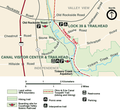 Ohio and Erie Canal Visitors Center map
 -
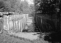 Deep Lock 28 as it existed in 1985
 -
 Graph showing the annual expenditures and revenues accrued to the State of Ohio by the Ohio and Erie Canal from 1827 to 1903.
 -
 The Akron Beacon Journal front page on March 25, 1913; two days after the flood
 -
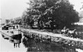 The Ohio and Erie canal in 1902
 -
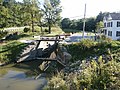 Restored canal Twelve Mile Lock 38, Cuyahoga Valley National Park
 -
 Restored canal boat

See also
References
- ^ a b c Mendinghall, Joseph S. (February 28, 1975), Template:PDFlink, National Park Service and Template:PDFlink
- ^ "National Register Information System". National Register of Historic Places. National Park Service. 2007-01-23.
- ^ a b "Ohio and Erie Canal". National Historic Landmark summary listing. National Park Service. Retrieved 2008-06-20.
- ^ U.S. Geological Survey Geographic Names Information System: Ohio and Erie Canal
- ^ Hagerty, J.E., McClelland C.P. and Huntington, C.C., History of the Ohio Canals, Their construction, cost, use and partial abandonment, Ohio State Archaeological and Historical Society, Columbus, OH 1905
- ^ Ehmann P&O
- ^ http://www.geocities.com/heartland/prairie/6687/pennohio.htm
- ^ a b c "Captain Pearl R. Nye: Life on the Ohio and Erie Canal". Retrieved 2007-04-21.
{{cite web}}:|first=missing|last=(help) - ^ by Jack Gieck; with an introduction by George W. Knepper (1988). A photo album of Ohio's canal era, 1825-1913. [Kent, Ohio]: Kent State University Press. ISBN 0-87338-353-2.
{{cite book}}: CS1 maint: multiple names: authors list (link) - ^ "Biography of James Garfield". The White House. Retrieved 2006-03-14.
- ^ "James A. Garfield". American Presidents: Life Portraits. Retrieved 2006-03-14.
- ^ Lock 44 manually plotted in Google Earth
- ^ "Ohio and Erie Canal and Towpath Trail, Part 2" (HTML). NorthEastOhio-RoadRunner.
- ^ "Ohio and Erie Canal and Towpath Trail, Part 3" (HTML). NorthEastOhio-RoadRunner.
- ^ Mill Creek Aqueduct manually plotted in Google Earth
- ^ Eleven Mile Lock 39 manually plotted in Google Earth
- ^ "Eleven Mile Lock 39 topographic map" (HTML). TerraServer-USA.
- ^ Twelve Mile Lock 38 manually plotted in Google Earth
- ^ "Twelve Mile Lock 38 topographic map" (HTML). TerraServer-USA.
- ^ a b U.S. Geological Survey Geographic Names Information System: Tinkers Creek Aqueduct
- ^ In 2007-2008-? Tinkers Creek Aqueduct is undergoing renovation following flood damage from Tinkers Creek (Cuyahoga River) and Cuyahoga River
- ^ Fourteen Mile Lock 37 manually plotted in Google Earth
- ^ "Fourteen Mile Lock 37 topographic map" (HTML). TerraServer-USA.
- ^ Pinery Dam and Feeder Lock 36 manually plotted in Google Earth
- ^ Pinery Dam and Feeder Lock 36 topographic map
- ^ Kettlewell Whiskey Lock 35 manually plotted in Google Earth
- ^ Whiskey Lock 35 topographic map
- ^ Red Lock 34 manually plotted in Google Earth
- ^ Red Lock 34 topographic map
- ^ U.S. Geological Survey Geographic Names Information System: Red Lock
- ^ Wallace Lock 33 manually plotted in Google Earth
- ^ Wallace Lock 33 topographic map
- ^ U.S. Geological Survey Geographic Names Information System: Wallace Lock
- ^ a b U.S. Geological Survey Geographic Names Information System: Boston Lock
- ^ Lonesome Lock 31 manually plotted in Google Earth
- ^ "Lonesome Lock 31 topographic map" (HTML). TerraServer-USA.
- ^ U.S. Geological Survey Geographic Names Information System: Lonesome Lock
- ^ Peninsula Feeder Lock 30 manually plotted in Google Earth
- ^ "Peninsula Feeder Lock 30 topographic map" (HTML). TerraServer-USA.
- ^ Peninsula Lock 29 manually plotted in Google Earth
- ^ "Peninsula Lock 29 topographic map" (HTML). TerraServer-USA.
- ^ Peninsula Aqueduct manually plotted in Google Earth
- ^ "Peninsula Aqueduct topographic map" (HTML). TerraServer-USA.
- ^ a b U.S. Geological Survey Geographic Names Information System: Deep Lock Deep Lock manually plotted in Google Earth
- ^ "Deep Lock 28 topographic map" (HTML). TerraServer-USA.
- ^ Johnny Cake Lock 27 manually plotted in Google Earth
- ^ "Johnny Cake Lock 27 topographic map" (HTML). TerraServer-USA.
- ^ a b U.S. Geological Survey Geographic Names Information System: Furnace Run Aqueduct
- ^ a b U.S. Geological Survey Geographic Names Information System: Pancake Lock
- ^ Pancake Lock 26 manually plotted in Google Earth
- ^ Mudcatcher Lock 25 manually plotted in Google Earth
- ^ Mudcatcher Lock 25 topographic map
- ^ Niles Lock 24 manually plotted in Google Earth
- ^ Niles Lock 24 topographic map
- ^ U.S. Geological Survey Geographic Names Information System: Pennsylvania and Ohio Canal
- ^ Ohio and Erie Canal miles are measured from its original connection with Lake Erie at Lock 44 on the Cuyahoga River.
External links
- Ohio and Erie Canal National Heritage Corridor
- Ohio and Erie Canal Map
- Ohio and Erie Canal Photo Essay
- Ohio and Erie Canal towpath trail
- Ohio and Erie Canal National Heritage Corridor, a National Park Service Discover Our Shared Heritage Travel Itinerary
- The Ohio & Erie Canal: Catalyst of Economic Development for Ohio, a National Park Service Teaching with Historic Places (TwHP) lesson plan
- The Ohio and Erie Canal in Cleveland
- An Inquisitive Visitor's Guide to the Ohio & Erie Canal and Towpath Trail
- "Water And Steel, Concrete And Earth", Erin O'Brien (writer), Cleveland Free Times, July 25, 2007
- Pictures around Waverly
| Topics | |
|---|---|
| Lists by state |
|
| Lists by insular areas | |
| Lists by associated state | |
| Other areas | |
| Related | |