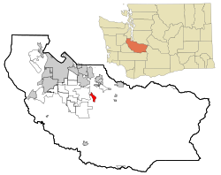
Orting, Washington
Orting, Washington | |
|---|---|
 Location of Orting, Washington | |
| Country | United States |
| State | Washington |
| County | Pierce |
| Area | |
| • Total | 2.7 sq mi (7.1 km2) |
| • Land | 2.7 sq mi (7.1 km2) |
| • Water | 0.0 sq mi (0.0 km2) |
| Elevation | 190 ft (58 m) |
| Population (2000) | |
| • Total | 3,760 |
| • Density | 1,372.2/sq mi (529.8/km2) |
| Time zone | UTC-8 (Pacific (PST)) |
| • Summer (DST) | UTC-7 (PDT) |
| ZIP code | 98360 |
| Area code | 360 |
| FIPS code | 53-52005Template:GR |
| GNIS feature ID | 1512539Template:GR |
Orting is a city located in Pierce County, Washington. As of the 2000 census, the city had a total population of 3,760 and 6,075 in 2008 according to the Washington State Office of Financial Management.
History
Orting is a small city located approximately 30 miles (48 km) from Mount Rainier. The first recorded claims for the land in Orting was made in the early 1850s, however, the city was officially incorporated in 1889. The town sits in a fertile valley between two major rivers, the Carbon and Puyallup Rivers, and it is built entirely on several layers of lahar deposits. Based on past lahar flow and the structure of Mount Rainier, Orting has been designated the most at-risk town in the event of lahar activity from the mountain. Scientists predict that lahars could reach Orting in as little as 30 minutes from origin. Authorities have installed a system of lahar sirens throughout the area, activated by sensors on Mt. Rainier. The local schools regularly stage lahar evacuation drills, and residents have been informed as to lahar escape routes (1). The Orting area is currently experiencing rapid growth due to suburban sprawl, putting increasing numbers of people at risk, and raising the spectre of gridlock should an evacuation be required.
Geography
Orting is located at 47°5'46" North, 122°12'19" West (47.096071, -122.205401)Template:GR.
According to the United States Census Bureau, the city has a total area of 2.7 square miles (7.1 km²), of which, 2.7 square miles (7.1 km²) of it is land and none of the area is covered with water.
Demographics
As of the censusTemplate:GR of 2000, there are 3,760 people, 1,318 households, and 999 families residing in the city. The population density is 1,372.2 people per square mile (529.8/km²). There are 1,382 housing units at an average density of 504.4/sq mi (194.7/km²). The racial makeup of the city is 92.37% White, 0.61% African American, 0.98% Native American, 1.25% Asian, 0.27% Pacific Islander, 1.28% from other races, and 3.24% from two or more races. 3.43% of the population are Hispanic or Latino of any race.
There are 1,318 households out of which 44.4% have children under the age of 18 living with them, 60.5% are married couples living together, 10.7% have a female householder with no husband present, and 24.2% are non-families. 18.7% of all households are made up of individuals and 7.4% have someone living alone who is 65 years of age or older. The average household size is 2.85 and the average family size is 3.26.
In the city the population is spread out with 32.8% under the age of 18, 7.3% from 18 to 24, 36.8% from 25 to 44, 14.4% from 45 to 64, and 8.8% who are 65 years of age or older. The median age is 30 years. For every 100 females there are 103.6 males. For every 100 females age 18 and over, there are 95.4 males.
The median income for a household in the city is $53,464, and the median income for a family is $55,335. Males have a median income of $41,486 versus $26,438 for females. The per capita income for the city is $18,951. 6.5% of the population and 4.2% of families are below the poverty line. Out of the total population, 5.2% of those under the age of 18 and 15.8% of those 65 and older are living below the poverty line.
Daffodil Parade
Every year, Orting is the fourth stop in the annual Daffodil Festival Parade. The parade has gone through downtown Orting since 1934.
References

